BlueSeas
Lake Champlain
Lake Champlain
Navigation and Cruising Guide
Whitehall, NY to the U.S. / Canadian Border
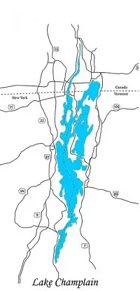
The head of Lake Champlain is not in the north as you might suspect, but has its beginning in the south at the terminus of the Champlain Canal (Lock #C12) in Whitehall, NY. From there, it flows generally northward for a distance of approximately 110 statute miles (95.6 NM / 177 KM).
The lake is, for the most part, located within the United States with a small portion extending into Canada. It is bordered by Vermont to the east, New York State to the south and west, and the Canadian Province of Quebec to the north.
The far northern end of Lake Champlain is Missisquoi Bay in Canada. However, for those in transit to or from the St. Lawrence River, it is probably best considered as being located at the U.S. / Canadian Border (approximately 1.4 SM (1.2 NM / 2.25 KM) north of Rouses Point, NY) where it empties into the head of Quebec’s Riviere Richelieu (Richelieu River).
For those continuing northbound, Lake Champlain allows passage to the Atlantic Ocean or the Great Lakes via the Richelieu River, Chambly Canal, and the St. Lawrence River.
When southbound out of Lake Champlain; the Atlantic Ocean can be accessed via the Champlain Canal and the Hudson River. The Great Lakes can also be accessed to the south via the Champlain Canal and then west on the Erie Canal.
Lake Champlain Facts
Length – 111.4 SM / 96.8 NM / 179.3 KM
Width – 12.0 SM / 10.4 NM / 19.3 KM; at its widest point.
Navigation Season
The navigation season for Lake Champlain typically runs from late April through late December when ice typically begins to occur in the shallower areas of the lake. 100% Ice cover, when it happens, generally occurs between mid-February and early March and is becoming less frequent. The lake is generally ice free by late April.
Aids to Navigation
Buoys and Marks
Buoys, beacons, and lights on Lake Champlain make use of the standard lateral buoy system of red and green.
The route from the St. Lawrence River via on the Richelieu River (southbound) and Lake Champlain (southbound) is considered to be returning from sea (Red Right Returning). Red buoys, beacons, and marks should be left to starboard.
The route (northbound) via the Champlain Canal is also considered to be returning from sea (Red Right Returning). Red buoys, beacons, and marks should be left to starboard.
Caution:
Buoyage system reversal occurs when entering or leaving the Champlain Canal at Lock #C12 in Whitehall, NY.
Charts
NOAA Charts #14784, #14783, #14782, and #14781 provide complete coverage of Lake Champlain from the U.S. / Canadian Border south to Whitehall, NY.
Chart Datum for Lake Champlain is “Low Lake Level” which is 93.0 feet above MSL.
Fluctuating Lake Levels - The water level of Lake Champlain is subject to variation from year to year with an observed range from 0.6 feet below to 8.8 feet above Low Lake Level.
During each year, the seasonal fluctuation is 4 to 5 feet, the lowest stage occurring in September or October and the highest stage in April or May.
Chart #14781 – Covers Lake Champlain from Riviere Richelieu, Quebec south to South Hero Island, VT.
Chart #14782 – Covers Lake Champlain from Cumberland Head, NY south to Four Brothers Islands.
Chart #14783 – Covers Lake Champlain from Four Brothers Islands south to Barber Point, NY.
Chart #14784 – Covers Lake Champlain from Barber Point, NY south to Whitehall, NY and the Champlain Canal.
Lake Champlain Facts
Average Depth – 64 feet (19.5 meters).
Deepest Point - 400 feet (121.9 meters) at approximately 44˚18’07”N / 73˚19’27”W.
Water Surface Elevation – Averages 98 feet (29.9 meters) above MSL.
Distances and Mileages
Distances between major points on Lake Champlain are listed below. The distances table is useful in planning overnight stops while transiting the lake and is available for download.
| Lake Champlain Distance Table | ||||||||||
|---|---|---|---|---|---|---|---|---|---|---|
| New York City | Troy Lock | Lock C12 - WhiteHall, NY | Chimney Point, VT | Port Henry, NY | Thompsons Point, VT | Burlington, VT | Plattsburgh, NY | Rouses Point, NY | Montreal, CA | |
| New York City | 0.0 | 154.2 | 217.9 | 255.3 | 257.1 | 273.3 | 287.3 | 302.7 | 327.2 | 497.6 |
| Troy Lock | 154.2 | 0.0 | 63.8 | 100.5 | 102.9 | 119.1 | 133.1 | 148.5 | 173.0 | 298.4 |
| Lock C12 | 217.9 | 63.8 | 0.0 | 36.7 | 39.2 | 55.4 | 69.4 | 85.7 | 110.4 | 279.7 |
| Chimney Point, VT | 255.3 | 100.5 | 36.7 | 0.0 | 1.8 | 18.0 | 32.0 | 47.4 | 71.9 | 242.3 |
| Port Henry, NY | 257.1 | 102.9 | 39.2 | 1.8 | 0.0 | 16.2 | 30.2 | 45.6 | 70.1 | 240.5 |
| Thompsons Point, VT | 273.3 | 119.1 | 55.4 | 18.0 | 16.2 | 0.0 | 14.0 | 29.4 | 53.9 | 224.3 |
| Burlington, VT | 287.3 | 133.1 | 69.4 | 32.0 | 30.2 | 14.0 | 0.0 | 19.4 | 40.5 | 165.9 |
| Plattsburgh, NY | 302.7 | 148.5 | 85.7 | 47.4 | 45.6 | 29.4 | 19.4 | 0.0 | 26.4 | 151.8 |
| Rouses Point, NY | 327.2 | 173.0 | 110.4 | 71.9 | 70.1 | 53.9 | 40.5 | 26.4 | 0.0 | 125.4 |
| Montreal, CA | 497.6 | 298.4 | 279.7 | 242.3 | 240.5 | 224.3 | 165.9 | 151.8 | 125.4 | 0.0 |
| Distances in Statute Miles | ||||||||||
The above table can be downloaded for your personal and private use. The Lake Champlain distance file contains the tables in Statute Miles, Nautical Miles, and Kilometers. The files are Zipped Adobe (.pdf) format.
Lake Champlain Distance Tables - Download
Speed Limits
The speed limits on Lake Champlain can be considered to be unlimited except where posted or common sense prevails. Keep in mind, you are still responsible for your wake.
Transit Times
As a general guide, Whitehall, NY to the U.S./Canadian Border could be done 3.2 hours at 30 knots.
More realistically, with a SOG of 15 knots you will probably require about 6.4 hours; 9.6 Hours at 10 knots, and 12.0 to 14.0 hours at typical trawler and sailboat speeds.
Lake Champlain Facts
Islands in Lake: ≈ 70 to 80 Islands the largest being Grande Isle, Isle La Motte, and North Hero, all being located in the northern part of the lake.
The (2) largest cities on Lake Champlain are Burlington, VT located on the eastern shore of the lake with a population of 42,200+ and Plattsburgh, NY on the western shore with a population of 19,600+.
Bridges, Locks, and Overhead Power Lines
Lake Champlain Bridge Schedule
The following table lists the bridges; their schedules, and restrictions on Lake Champlain north from Whitehall, NY to the U.S./Canadian Border.
The minimum overhead clearance for all fixed bridges on Lake Champlain is 8 feet.
This list is believed to be accurate as of July 2026. If any errors or omissions are noted, please e-mail us at with any corrections or recommendations.
| Lake Champlain Bridge Schedule Whitehall to Rouses Point |
|||||
|---|---|---|---|---|---|
| Mile Marker | Bridge | Charted Vert. Clear. | Schedule | Restrictions | VHF |
| 37.2 | Samuel de Champlain Bridge | 75’ | Fixed Bridge | ||
| 82.6 | Sand Bar Bridge | 15’ | Fixed Bridge | ||
| 91.8 | US Route 2 Bascule Bridge | 18’ | The draw shall open on signal on the hour and the half hour from 5/15 through 10/15 from 0800 to 2000 daily. | The draw shall open on signal from5/15 through 10/15 from 2000 to 0800 if at least four hours notice is given by calling the number posted at the bridge. The draw shall open on signal from 10/16 through 5/14 if at least four hours notice is given by calling the number posted at the bridge. | Caution Temp. Deviations due to construction and reduced clearances. |
| 99.2 | North Hero-Alburg Tongue Bridge | 26’ | Fixed Bridge | ||
| 99.4 | Isle La Motte-Alburg Tounge Bridge | 8’ | Fixed Bridge | ||
| 105.6 | Central Vermont RR Swing Bridge | 11’ | On Demand from 6/15 through 9/15: Monday through Friday from 0900 to 1700; Weekends, Independence Day & Labor Day from 0700 to 2300; At all other times, if at least two hours notice is given. | 9/16 through 6/14 - 24 hours notice required by calling the number posted at the bridge. | 802-527-3480 |
| 105.9 | Missisquoi Bay Bridge | 35’ | Fixed Bridge | ||
| 109.1 | Rouses Point Bridge | 56’ | Fixed Bridge | ||
| Distances in Statute Miles. Distances are northbound from Lock C12 at Whitehall, NY. | |||||
The above table can be downloaded for your personal and private use. The Lake Champlain Bridges file contains the tables in Statute Miles, Nautical Miles, and Kilometers. The files are Zipped Adobe (.pdf) format.
Lake Champlain Bridge Tables - Download
Lake Champlain - Overhead Cables and Power Lines
Approximately (3) overhead cables cross Lake Champlain. (2) Cable crossings are just north of Lock #C12 at Whitehall, NY at (MM 0.3) and (MM 1.0) with no clearance data available. The 3rd cable crossing is just north of the Route 2 Bascule Bridge at (MM 92.0) with a vertical clearance of 47’.
Caution - Many of the overhead cables over the waterway carry high voltage, and an extra margin of safety should be allowed during threatening weather.
Lake Champlain Facts
Shoreline = 587 SM/510.1 NM/944.7 KM
Surface Area - 490 square miles/1,269 square KM
Volume of Water - 6.8 trillion gallons of fresh water.
Weather
Average weather conditions at Burlington, VT over the course of the normal boating season May thru the end of September has temperatures ranging from 67/45 in May, 76/55 in June, 81/60 in July, 79/58 in August, 70/51 in September.
NOAA Weather Radio broadcasts for Lake Champlain originate out of Burlington, VT (KIG60) on 162.400 MHz (WX2). This station provides almost continuous coverage of Lake Champlain from Whitehall, NY to the Canadian Border; offering current and forecasted weather and emergency alerts.