Whether you are cruising offshore along North Carolina’s coast or making use of the Atlantic Intracoastal Waterway, there are numerous Entrances, Inlets, or Passes between the deep waters of the Atlantic Ocean and the inland waters of North Carolina. Most all provide access to sheltered inland waters with many providing access to the Atlantic Intracoastal Waterway.
From Oregon Inlet in the north to Mad Inlet to the south, at last count in January 2020, there were (≈22). It should be kept in mind that many of these entrances and inlets are only suitable for very shallow draft vessels along with strong local knowledge. A good number however, can be considered navigable for most vessels. We have listed them below along with useful information on each to aid you in deciding if you wish to use a particular inlet.
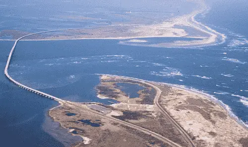
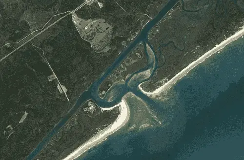
Oregon Inlet
Oregon Inlet located 64.7 NM SSE of Rudee Inlet, VA and 64.5 NM northward of Hatteras Inlet, or about 2.5 miles southward of Bodie Island Light. Oregon Inlet provides access to Pamlico Sound and eventually the AICW.
The Atlantic Intracoastal Waterway can be intersected if northbound about 29.2 NM above the entrance near buoy (Fl G 2.5s 15ft 5M "1AR") near (MM "79.0"). If southbound about 71.7 NM below the entrance - near lighted beacon (Fl R 4s 15ft 5M "2") at (MM "167.9").
Approach
The approach is marked by a lighted buoy (RW "OI" Mo(A) WHIS) located 2.4 NM NNE of the entrance at 35°48’38" N / 075°30’56" W. NOTE: The position of this buoy is frequently shifted with changing conditions. Topmark is not installed on this aid.
Prominent on the approach is Bodie Island Light (Fl (2) 30s 156ft 18M) shown from a conical brick tower, white and black bands above granite base, black ironwork. A 150 foot radio tower operated by the Coast Guard is 1.7 NM NNW of the entrance and is also visible on the approach.
The approach is over a shifting bar and the buoys are not charted due to being frequently shifted in position to mark the best water. Breakers, charted, and uncharted, and wrecks line the approach channel and are covered with a least depth of 2 feet.
Entrance
The entrance is protected by a jetty on the south side. The jetty is marked by "Oregon Inlet Jetty Light" shown from a pile with a black and white diamond-shaped daymark. A fixed highway bridge crosses the inlet. The new Bonner Bridge will have a vertical clearance of 70 feet.
The inlet, used by local fishing vessels is not recommended to strangers. It requires continuous dredging; it deepens with northwest winds and fills in with northeast winds.
Cautions
The aids to navigation in Oregon Inlet and Oregon Inlet Channel to the junction with Old House Channel, and buoys in Walter Slough, Old House Channel and Davis channel are not charted because they are moved frequently. The hydrography in Oregon Inlet is also not shown due to its continually shifting nature. Continuous shifts in the channel conditions due to recent weather conditions may have rendered aids to navigation unreliable in North Carolina's Outer Banks Inlets. Mariners should use extreme caution when operating in these areas. Mariners are urged to seek alternate routes for transits to and from the sea.
Tides & Currents
Tides and Currents - Mean tidal range at the inlet is about 2 feet. Tidal currents in the inlet are reported to be as much as 5 knots, but with southwesterly winds as much as 6 to 8 knots.
Hydrographic Surveys
The most recent US Army Corps of Engineers Hydrographic Depth Surveys can be found for:
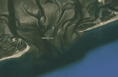
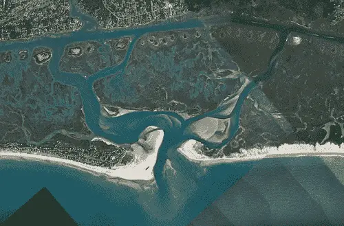
Hatteras Inlet, 12.3 NM west-southwest of Cape Hatteras Light, 67.3 NM SSW of Oregon Inlet, and 12.4 NM northeast of Ocracoke Inlet affords access to Hatteras, NC, the Pamlico Sound, and the AICW.
The Atlantic Intracoastal Waterway can be intersected about 50.7 NM WNW of the entrance near lighted beacon (Fl (2+1 R 6s 18ft 5M "PR") near (MM "146.6").
Approach
The approach is marked by a lighted buoy (RW "HI" Mo(A) WHIS) located 1.5 NM south of the entrance near 35°09’48" N / 075°45’15" W. NOTE: The position of this buoy is frequently shifted with changing conditions.
The approach is made over a shifting bar that is subject to continual change. Some buoys are not charted due to being frequently moved to show the best water.
Prominent on the approach is Hatteras Inlet Light (Iso 6s 48ft 10M) shown from a skeleton tower on a black house on the southwestern point of Hatteras Island.
Entrance
The entrance is a dredged channel that leads to Rollinson Channel 1.8 NM northeast of the entrance. The entrance channel is reported to shoal rapidly and should only be used with local knowledge. It is marked by lighted and unlighted beacons and buoys whose positions are being changed frequently.
A second marked channel leads southeast and is used by the Hatteras Inlet Coast Guard Station and the
North Carolina State Ferry.
Cautions
Hatteras Inlet is suject to continual change. Entrance buoys are not charted because they are frequently shifted in position.
Tides & Currents
The mean tidal range is 2.0 feet. The tidal currents in the channel through the inlet are influenced by winds and attain velocities of about 2 knots.
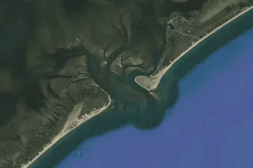
Ocracoke Inlet
Ocracoke Inlet, 12.4 NM southwest of Hatteras Inlet and 18.3 NM northeast of Drum Inlet provides access to Core Sound, Pamlico Sound, and eventually the AICW.
The Atlantic Intracoastal Waterway can be intersected about 36.8 NM north-westward of the entrance near lighted beacon (Fl (2+1 R 6s 18ft 5M "PR") near (MM "146.6").
Approach
The approach is marked by unlighted can buoy (G "1") located 1.5 NM SE of the entrance near 35°02’56" N / 075°59’47" W. NOTE: The position of this buoy is frequently shifted with changing conditions.
Prominent on the approach is Ocracoke Light (F 75ft 15M) northward of the entrance.
Entrance
Ocracoke entrance is subject to frequent changes. Numerous buoys are not charted due to being frequently moved to mark the best water. The approach and entrance is over a shifting bar between the southern end of Ocracoke Island and the northern end of Portsmouth Island; the bar is subject to frequent changes.
Cautions
There are unmarked shallow channels leading from Ocracoke Inlet to Pamlico Sound, but they should not be used without local knowledge because of the shifting shoals. Strong currents have been experienced in these channels. Mariners are advised to exercise caution while navigating in the area.
Tides & Currents
Tidal range is 1.9 feet. The currents in the inlet and connecting channels are influenced by the winds. The ebb current usually has a greater velocity than the flood. Velocities up to 4 knots have been observed.
Hydrographic Surveys
The most recent US Army Corps of Engineers Hydrographic Depth Surveys can be found for:
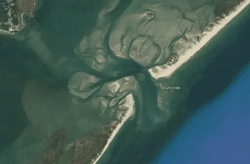
New Drum Inlet, 17 NM southwestward of Ocracoke Inlet, is an opening in the barrier beach leading to deeper water in Core Sound. The channel is unmarked, not maintained by dredging, and is constantly shifting. The inlet was reported to be dangerous and not recommended for use by anyone.
Ophelia Inlet
Ophelia Inlet, 4 NM southwestward of New Drum Inlet, is reported to be open, but not recommended for use filled in and closed to navigation.
Note
Drum, New Drum, Old Drum, and Ophelia Inlets are extremely dynamic. They fill in and reopen on a regular basis. Unless you are very familiar with these inlets, they are best avoided.
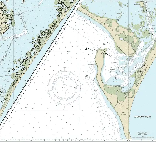
Cape Lookout Bight / Barden Inlet
Lookout Bight, on the west side of Cape Lookout is 6.9 NM east of the Beaufort Inlet approach buoy. We have included this more as an anchorage than an inlet, although shallow draft vessels can access Core Sound and the AICW via this inlet with careful navigation.
The Atlantic Intracoastal Waterway can only be intersected by vessels drawing 2 feet or less about 15.6 NM north-westward of the entrance through tortuous channels near lighted buoy (G "23" Fl G 2.5s) near (MM "204.4").
As an anchorage, Lookout Bight affords good protection for vessels in the inner bight in 7 to 28 feet, good holding ground of soft mud. Prevailing swell from the southwest is effectively excluded, but the surrounding terrain is too low to greatly restrain the force of wind. A severe blow from a northerly direction may cause a vessel to drag, but most boats drop an extra anchor if the wind reaches gale force from any direction.
Approach
The best approach is marked by lighted buoy (RW "BM" Mo)A) WHIS RACON (––) AIS) located at 34°34’49" N / 076°41’33" W, about
6.9 NM WSW of the Lookoput Bight entrance.
Prominent on the approach is Cape Lookout Light (Fl 15s 156ft 14M) southeast of the entrance.
Entrance
The entrance to Lookout Bight is naturally deep with depths of 10 to 21 feet and marked by unlighted buoy (R "4") located at 34°38’15" N / 076°33’04" W.
Cautions
Power Squadron Spit, the west side of Lookout Bight, is subject to continual change and is partially protected by a rubble-stone breakwater awash at low water and hardly visible when a heavy sea is running; its outer end is marked by a lighted buoy about 300 yards northwestward of its seaward end. Mariners should give it a wide berth in bad weather.
A channel extends from deep water in Lookout Bight through Barden Inlet and Lighthouse Bay to deep water in Back Sound. The channel is very unstable and has a tendency to fill; strangers should use extreme caution. The channel is marked, but the uncharted buoys and daybeacons through Barden Inlet are frequently shifted in position to mark the best water; local knowledge is advised.
There are unmarked and shallow channels leading from the inle through Core Sound to Pamlico Sound, but they should not be used without local knowledge because of the shifting shoals. Mariners are advised to exercise caution while navigating in this area.
Tides & Currents
Tidal range is 4.0 feet. The currents in the inlet and connecting channels are influenced by the winds. The ebb current usually has a greater velocity than the flood.
Hydrographic Surveys
The most recent US Army Corps of Engineers Hydrographic Depth Surveys can be found for:
Beaufort Inlet is 57.5 NM southwestward of Ocracoke Inlet, 20.4 NM east of Bogue Inlet, and about 220 NM southwestward of the Chesapeake Bay Entrance and the same distance northeastward of Charleston. The entrance lies between Shackleford Banks Island to the east and Bogue Banks to the west. It provides access to the Atlantic Intracoastal Waterway, Beaufort, and Morehead City, NC.
The AICW can be intersected about 2.2 NM above the entrance near lighted buoy (G "23" Fl G 2.5s) near (MM "204.4").
Approach
The approach is marked by lighted buoy (RW "BM" Mo)A) WHIS RACON (––) AIS) located 6.8 NM SSE of the entrance at 34°34’49" N / 076°41’33" W.
The approach is deep with a project depth 45 feet over the bar. It is well-marked with lighted buoys and lighted ranges.
Prominent on the approach is Cape Lookout Light (Fl 15s 156ft 14M) 8.0 NM east of the approach buoy, the tallest water tank at the State Ports Authority Terminal and the Highway 70 bridge over the Newport River being the most conspicuous landmarks from seaward.
Entrance
The entrance is also deep and well-marked with lighted buoys and ranges.
Cautions
Cape Lookout Shoals is the principal danger in the approach to Beaufort Inlet. A dump site for dredged material is just west of the entrance channel. Lesser depths than charted may exist in these areas; caution is advised. A number of wrecks, some of which are marked, are in the approaches.
Heavy swells build up in Beaufort Inlet Channel with northerly or southerly winds, making boating hazardous.
Tides & Currents
The tidal range is about 3.5 feet. Tidal currents along Beaufort Inlet Channel attain velocities of up to about 2 knots. They usually set along the channels, except at the entrance to Morehead City Channel, they usually set across the channel near the end of the flood period and beginning of the next ebb. It was reported in 1983 that the current will attain a velocity of 4 to 5 knots off the southwest corner of the State Ports Authority Terminal, and whirlpools will develop off the southeast corner at maximum tides.
Bogue Inlet
Bogue Inlet is located 20.4 NM west of the Beaufort Inlet Approach Buoy and 12.9 NM northeast of New River Inlet. It affords access to the AICW and Swansboro, NC. The entrance lies between Bogue Banks to the east and Bear Island to the west.
The Atlantic Intracoastal Waterway is intersected 2.1 NM above the entrance at (MM "227.6") near lighted beacon (Fl G 2.5s 15ft 4M "45").
Approach
The approach is marked by buoy (RW "BI" Mo(A) WHIS located 1.1 NM SSE of the entrance at 34°37’35" N / 077°06’07" W.
The approach to the inlet is obstructed by a shifting bar extending about 0.5 NM seaward and is subject to frequent change. The approach channel is shallow and marked by uncharted lighted and unlighted buoys that are frequently shifted to mark the best water. Strangers should wait for a rising tide and never attempt to enter when the bar is breaking.
Entrance
The entrance channel is also subject to frequent change. The approach and entrance channel has moderate depths of 12 to 30 feet and marked by uncharted lighted and unlighted buoys that are frequently shifted to mark the best water.
The channels inside the inlet shoal rapidly with depths of 6 to 10 feet and are also subject to considerable change, particularly during southeast and southwest storms.
Cautions
Dangers - A fish haven, covered 15 feet, is about 4 miles southeastward of Bogue Inlet.
Tides & Currents
Tides and Currents - The mean range of tide is 2.2 feet in the inlet.
Hydrographic Surveys
The most recent US Army Corps of Engineers Hydrographic Depth Surveys can be found for:
Bear Inlet is 3 miles westward of Bogue Inlet. It is unmarked and used by local boats only; it is not recommended to strangers.
Cautions
Danger zones of firing ranges are in the ocean between Bear Inlet and New River Inlet and in New River. A Sea Turtle Sanctuary, Marine Protected Area (MPA), extends from Bogue Inlet to New River Inlet.
Brown's Inlet
Browns Inlet is 6 miles westward Bogue Inlet. It is unmarked and used by local boats only; it is not recommended to strangers.
Cautions
Danger zones of firing ranges are in the ocean between Bear Inlet and New River Inlet and in New River. A Sea Turtle Sanctuary, Marine Protected Area (MPA), extends from Bogue Inlet to New River Inlet.
New River Inlet
New River Inlet is 35.0 NM westward of Beaufort Inlet and 19.0 NM northeast of New Topsail Inlet. It provides access to the AICW, Sneads Ferry, and Camp Lejeune, NC.
The Atlantic Intracoastal Waterway is intersected 0.9 NM above the entrance at (MM "246.0") near (R N "74").
Approach
The approach is marked by lighted buoy (RW "NR" Mo(A) WHIS) located 1.0 NM SSE of the entrance at 34°31’02" N / 077°19’33" W.
The approach channel to the inlet is obstructed by a shifting bar subject to continual change and depths of 7 to 12 feet. Local knowledge is advised. Buoys marking the approach channel are not charted because they are frequently shifted in position.
Entrance
The entrance channel is generally deeper, but likewise subject to continual change and should be entered with caution.
Cautions
Caution is advised when navigating this area. A strong ebb current from the inlet causes a break on the bar when there is a sea outside. The break is especially bad when the ebb sets against a south or southeast wind.
New River Inlet is considered dangerous by local pilots, and entrance should not be attempted except under the most favorable conditions.
Tides & Currents
The mean range of tide at the inlet is 3 feet. A strong ebb current exists.
Hydrographic Surveys
The most recent US Army Corps of Engineers Hydrographic Depth Surveys can be found for:
The Atlantic Intracoastal Waterway is intersected 1.7 NM above the entrance at (MM "270.0") near (G C "99").
Approach
The approach is marked by lighted buoy (RW "NT" Mo(A) WHIS) located 1.3 NM ESE of the entrance at 34°20’12" N / 077°38’27" W.
The approach channel is over a shifting bar. The buoys marking the approach channel are not charted due to being shifted frequently to mark the best water.
Entrance
The bar channel leads to a junction with two dredged channels inside the entrance. The buoys marking the bar channel are frequently shifted in position to mark the best water and therefore not charted; caution is advised.
Howards Channel inside the entrance is well marked with unlighted buoys with a charted depth 8 to 11 feet of water (2019) to the intersection with the AICW. The channel is subject to continual change and the buoys mark the best water. Local knowledge is advised.
Cautions - Caution is advised when navigating this area, the inlet should not be entered by strangers. A southwesterly or northwesterly storm totally changes the configuration of the inlet.
Tides & Currents
Tides and Currents - The mean range of tide at the inlet is 3.0 feet.
Hydrographic Surveys
The most recent US Army Corps of Engineers Hydrographic Depth Surveys can be found for:
Little (Old) Topsail Inlet, 1.5 miles southwestward of New Topsail Inlet has filled in and is closed to navigation.
Rich Inlet
Rich Inlet, about 4.5 miles southwestward of New Topsail Inlet, is constantly changing and is no longer marked. It is used by some locals, but should not be attempted by strangers.
Mason Inlet
Mason Inlet is 8.5 miles southwestward of New Topsail Inlet. In 2002 it was reported to have 12 feet water at the entrance, thence 10 feet to the Intracoastal Waterway. The inlet has changed since then and is subject to continual change. Local knowledge is advised.
Masonboro Inlet
Masonboro Inlet is located about 12.5 NM southwestward of New Topsail Inlet and 22.3 NM NNE of Cape Fear. It provides access to the AICW, Masonboro, and Wrightsville, NC.
The Atlantic Intracoastal Waterway is intersected 0.6 NM above the entrance at (MM "293.6") near (G C "155").
Approach
The approach is marked by a lighted buoy (RW "CB" Mo(A) WHIS) located 1.0 NM ENE of the entrance at 34°04’54" N / 077°51’11" W.
The buoyed approach is over a shallow bar with a least charted depth of 6 feet with the buoys marking the best water. The buoys are not charted due to frequent changes to mark the best water.
Prominent on the approach is a 452-foot tower almost in line with the approach course to the inlet.
The approach channel is subject to continual change - caution is advised.
Entrance
The entrance is likewise marked with uncharted buoys and channel depths of 7 to 40 feet. The entrance is subject to continual change and local knowledge is advised.
Cautions
Wrecks and obstructions just to the south of the entrance.
The inlet is subject to continual change and should be used only with local knowledge.
Tides & Currents
The mean range of tide on the bar is 4.2 feet.
Hydrographic Surveys
The most recent US Army Corps of Engineers Hydrographic Depth Surveys can be found for:
New Inlet, about 17.5 miles south of Masonboro Inlet and 4.7 miles north-northeast of Cape Fear, has filled in and is reported closed to navigation.
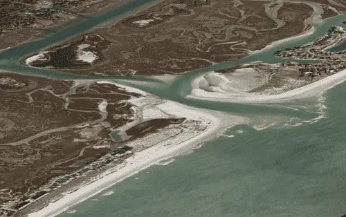
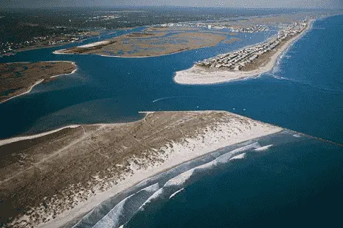
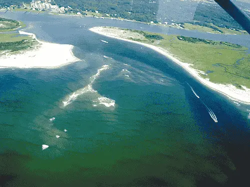
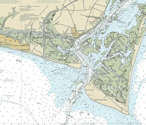
Cape Fear River Entrance
Cape Fear River is the approach to the city of Wilmington, NC and lies immediately westward of Cape Fear, 363 miles south of Norfolk, VA, and 315 miles north of Jacksonville, FL, by coastwise routes. It provides access to the AICW, Southport and Wilmington, NC.
The Atlantic Intracoastal Waterway can be intersected 2.9 NM above the entrance at (MM "308.5") near lighted buoy (R "18" Fl R 4s).
Approach
The approach is marked by a lighted buoy (RW "CF" Mo(A) WHIS RACON(–·–·) AIS ) located 6.8 NM SSW of the entrance at 33°46’17" N / 078°03’02" W.
Prominent on the approach is Oak Island Light (Fl(4) 10s 169ft 24M),
shown from a cylindrical tower, upper part black, middle white, and lower part gray, on the western side of Cape Fear River entrance. An abandoned lighthouse on the west side of Smith Island. Water tanks at Yaupon Beach and Southport and at Kure Beach and two silver radar domes about 1.3 miles southward of the tank at Kure Beach are visible well to seaward. Frying Pan Shoals platform tower (33°29’06" N., 77°35’24" W.) is reported to be a good radar target in the approach to Cape Fear River.
The approach is deep with a controlling depth of not less than 37 feet mid-channel. It is well-marked by lighted buoys and lighted ranges. Shoals line the upper limits of the approach with depths of 10 feet to bare in spots.
On the approach to Cape Fear River from northward, the safer course is outside of Frying Pan Shoals Lighted Buoy 16. When approaching from the south vessels should set a course to pass outside the broken ground extending offshore between Cape Romain and Winyah Bay. When clear of this broken ground, the course can be shaped for Cape Fear River Entrance Lighted Whistle Buoy CF.
Entrance
The entrance is deep with a least controlling depth of 39 feet to the intersection with the AICW, it is well-marked with lighted buoys and lighted ranges
Cautions
Frying Pan Shoals are the principal danger in the approaches to Cape Fear River. Isolated wrecks, some marked, and obstructions with varying depths over them are in the approaches. Bald Head Shoal and Jay Bird Shoals (Middle Ground) are dangerous shoals on either side of the bar channel.
Caution should be exercised in Cape Fear River at times when tides are higher than normal and after heavy rains as logs and floating debris may be encountered.
Tides & Currents
Tides and Currents - Mean tidal range is 4.5 feet. The tidal currents on the bar run with considerable velocity and as a rule set nearly in the direction of the channels, but on the last of the flood and first of the ebb they set to the eastward across the channel, and on the beginning of the flood they set to the westward. In the entrance and river they set in generally the direction of the channel. The relative velocities of flood and ebb depend upon the stage of the river. During freshets the flood at times is completely overcome by the river current and the ebb is greatly increased.
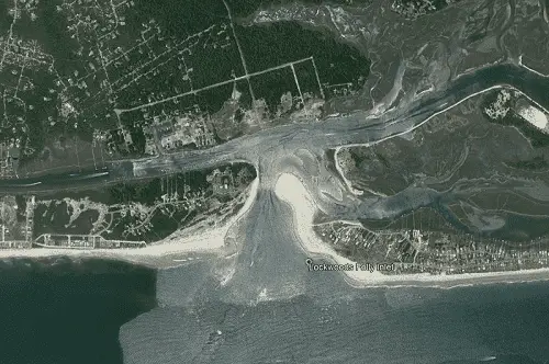
Lockwoods Folly Inlet
Lockwoods Folly Inlet is found 11 NM westward of the Cape Fear River Entrance and 7.1 NM ENE of Shallotte Inlet. It provides access to the AICW and Holden Beach, NC.
The Atlantic Intracoastal Waterway is intersected 0.4 NM above the entrance at (MM "321.6") near unlighted buoy (G C "47A").
Approach
The approach channel is over a shifting bar that breaks at virtually all stages of tide and wind. It is shallow with depths of 4 to 11 feet (April 2020) and is marked with uncharted and unlighted buoys.
Entrance
The entrance channel deepens with depths of 6 to 20 feet. It is navigable, but poorly marked until its junction with the AICW.
Cautions
There are three charted wrecks, all showing at low water, near the entrance to the inlet; two are at the mouth, and the other is about 0.3 mile to the westward 200 yards offshore.
Strangers should not attempt this inlet.
Tides & Currents
The mean range of tide is 4.2 feet at the entrance.
Hydrographic Surveys
The most recent US Army Corps of Engineers Hydrographic Depth Surveys can be found for:
Shallotte Inlet is located 19 NM westward of Cape Fear River, is entered between Holden Beach to the east and Ocean Isle Beach to the west. It provides access to the AICW.
The Atlantic Intracoastal Waterway can be intersected 0.5 NM above the entrance at (MM "330.4") near unlighted buoy (R N "80A").
Approach
The approach is marked by a lighted buoy (RW "SH" Mo(A) WHIS) located 1.0 NM south of the entrance at 33°52’58" N / 078°22’54" W. NOTE: The position of this buoy is frequently shifted with changing conditions.
The approach is made over a shifting bar. The bar channel is subject to continual change, and the buoys marking it are shifted frequently to mark the best water and therefore not charted.
Entrance
The entrance channel is winding and is also subject to continual change; the buoys are not charted.
Cautions
The inlet, used only by local fishermen and not recommended to strangers.
Tides & Currents
Tides and Currents - Mean tidal range at the inlet is about 4.6 feet.
Tubb's Inlet
Tubbs Inlet, 4 NM northeast of Little River Inlet Approach Buoy and 6 NM westward of Shallotte Inlet, is seldom used. It is unmarked and not recommended to strangers. A shifting bar with breakers extends offshore.
Mad Inlet
This inlet is completely filled in and is now closed to navigation.