Delaware Bay Entrance
Located 139.3 NM South of the New York Harbor Entrance and 118.2 NM North of the Chesapeake Bay Inner Approach Buoy. The Delaware Bay Entrance provides access to the Harbor of Refuge at Lewes, DE, the western terminus of the Cape May Canal, the NJICW, the eastern end of the C&D Canal at Delaware City, DE, Wilmington, DE, Marcus Hook, PA Camden, NJ, Philadelphia, PA, and Trenton, NJ.
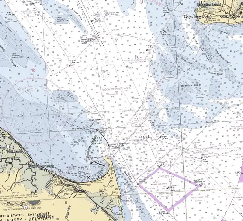
NOAA Chart #12214 - Cape May to Fenwick Island is suggested for the approach to the Delaware Bay while NOAA Chart #12304 - Delaware Bay is suggested for the entrance.
The Delaware Bay Entrance is 9.75 NM wide between Cape May Point, NJ and Cape Henlopen, DE. The northeastern portion of the entrance is comprised of numerous shoals with depths of 5 to 30 feet and a small area that is un-surveyed. The deep water entrance is 3.1 NM wide.
Approach
The safest approach to the Delaware Bay is from the east through southeast via the two Traffic Separation Schemes to the Delaware Bay. These approaches are deep with depths greater than 40 feet, well-marked by lighted yellow buoys, and with few off-lying dangers.
Prominent on the approach to the Delaware Bay Entrance at night is "Cape May Light" (Fl 15s 165ft 22M) on the northern side of the bay entrance and the "Harbor of Refuge Light" (Fl 10s 72ft 16M HORN) on the southern side of the bay.
The inner approach is marked by lighted buoy (RW "CH" Mo (A) WHIS RACON (— · —)) located 4.4 NM SSE of Cape Henlopen at (38°46’13" N / 075°01’20" W).
Entrance
The natural entrance is deep with depths of 40 to 146 feet. It is well-marked with lighted and unlighted buoys and secondary lights. Charted shoals covered 16 to 30 feet line both sides of the entrance. Caution, heavy traffic area.
The improved channel north of Brown Shoal Light has a Federal project depth of 40 feet to a point about 7.0 NM south of Trenton, NJ.
Cautions
Shoals (Prissy Wicks, Middle, Somer, Overfalls, and Hen and Chickens) cover the majority of the entrance. From Cape May Point shoals extend 6.75 NM to the SW and 7.4 NM to the south with depths ranging from 4 to 30 feet. From Cape Henlopen 1.0 NM to the east with depths of 9 to 23 feet.
An unmarked Channel (Cape May Channel) through the shoals is often used by local fishermen. It should not be attempted without local knowledge.
Mariners should be especially vigilant while navigating in the Delaware Bay Entrance area between Delaware Bay Approach Lighted Whistle Buoy "CH" and Brown Shoal Light. This highly congested area includes a pilotage transfer area, ferries crossing between Cape May and the Harbor of Refuge, and commercial vessels proceeding inbound and outbound to the main ship channel as well as large tugs and tows. Also, large deep-draft tankers will be proceeding out of the Big Stone Beach anchorage area and turning into the main navigational channel starting at Brown Shoal Light.
Tides & Currents:
Tidal range at the entrance is ≈4.5 feet. Current velocities average 1.8 knots in the entrance.
Notes
For those transiting the Delaware Bay and River to the Chesapeake & Delaware (C&D) Canal:
If you are looking for increased SOG, Fuel savings, or both, timing the Delaware Bay for a fair current push up the bay to the the eastern entrance of the C&D Canal is a must. The C&D canal lies 51.5 NM above the Delaware Bay Entrance, 49.9 NM above the western entrance to the Cape May Canal, and 41.5 NM above Brandywine Shoal Light.
If your vessel is capable of a STW of 7 knots or better, the trip up to the C&D Canal can be done with a fair current.
Unfortunately, low powered vessels are not as lucky when southbound out of the C&D Canal bound for the Capes. A vessel that is capable of 15 knots however, should be able to make it on a fair current.
Indian River Inlet
Indian River Inlet is found 9.7 NM south of Delaware Bay Entrance and 17.1 NM north of the Ocean City Inlet Approach Buoy. It is the first opening in the barrier beach south of Delaware Bay as well as the southernmost inlet on the Delaware Coastline. A U.S. Coast Guard Station is located just inside the entrance.
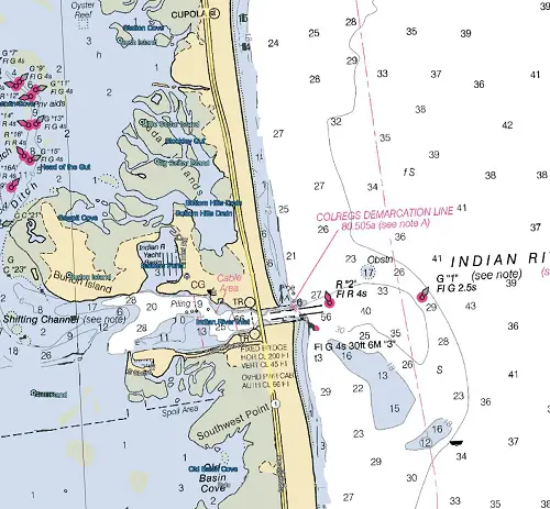
NOAA Chart #12216 - Cape Henlopen to Indian River Inlet is suggested for both the approach and entrance to Indian River Inlet.
Approach
The approach to Indian River Inlet is marked by lighted buoy (G "1" Fl G 2.5s) about 0.6 NM east of the entrance at 38°36’32" N / 075°02’47" W.
The approach is deep and has a least charted depth of 17 feet over an obstruction to the northeast of the entrance.
Entrance
The entrance is marked by a lighted buoy (R "2" Fl R 4s) just off the end of the northern jetty, and a lighted beacon (Fl G 4s 30ft 6M "3") is on the end of the south jetty.
A fixed highway bridge over the inlet has a clearance of 45 feet. An overhead power cable with a clearance of 66 feet crosses the inlet about 75 yards westward of the bridge.
It is reported to be deep and free from obstructions.
A channel leads from Indian River Inlet through Indian River Bay and up Indian River to Millsboro, 12 miles above the inlet. The channel from the entrance to Buoy 20 in Indian River Bay is subject to continual change due to severe shoaling. The channel is marked by uncharted buoys that are frequently shifted to mark the best water. The channel to Millsboro is marked by daybeacons and seasonal buoys.
Cautions
The aids to navigation in Indian River Inlet and Rehoboth Bay are unreliable and the remaining portions of fixed aids, damaged or destroyed by ice or coastal storms may be hazardous to navigation. Extreme caution in navigating this area is advised. Inlet River Buoys "4" through "17" mark a shifting channel and are not charted.
Tides & Currents
The current velocity is about 2 knots; caution is necessary, because the buoys sometimes tow under. Tidal Range is approximately 3.9 feet.