Whether you are making use of the Gulf Intracoastal Waterway (GIWW) or sailing coastwise along Florida’s Forgotten or Emerald Coastline’s, there are numerous Entrances, Inlets, or Passes between the deep waters of the Gulf of Mexico and the Panhandle Coastline of Florida. From East Pass (Carrabelle, FL) west to Pensacola Bay, there were 10 at last count in January 2020. All providing access to sheltered inland waters and most providing access to the Gulf Intracoastal Waterway.
While many of these are only suitable for shallow draft vessels and/or local knowledge, some can be considered navigable for most vessels. We have listed them below along with useful information on each to aid you in deciding if you wish to use a particular inlet.
East Pass
The principal entrance into St. George Sound. Lying between Dog Island and St. George Island, East Pass is found 131.5 NM NW of Anclote Key on Florida’s West Coast and 36.5 NM east of Cape San Blas. Leading in from the Gulf of Mexico, it provides access to the eastern terminus of the GIWW, Carrabelle, and Apalachicola, FL.
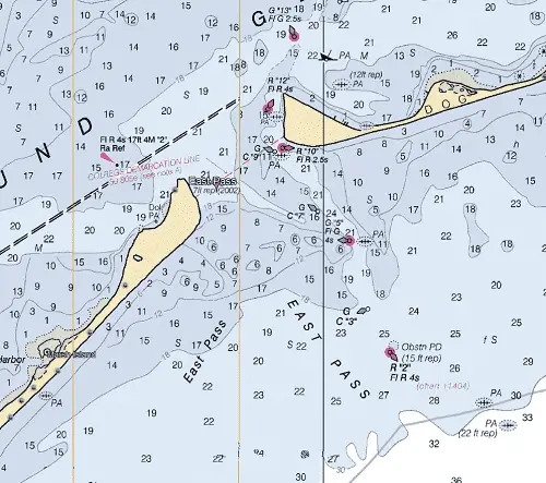
NOAA Chart #11405 - Apalachee Bay is suggested for the approach to St. George Sound while NOAA Chart #11404 - Carrabelle to Apalachicola is suggested for the entrance.
The Gulf Intracoastal Waterway (GIWW) can be intersected 0.4 NM above the entrance at MM "375.4 EHL" in the vicinity of buoy (R "12" Fl R 4s).
Approach
The approach to East Pass is marked by buoy (R “2”, Fl R 4s); lying 2.5 NM SSE of the entrance at (29°44’33" N / 84°39’12" W).
The approach channel is deep showing charted depths of 19 to 25 feet and marked by lighted and unlighted buoys. Shoals covered 5 to 18 feet line both sides of the approach.
In heavy seas, deep-draft vessels should stay in depths of 30 to 40 feet until the approach buoy is sighted.
Prominent on the approach from the southeast, on a clear day, are the sand dunes on Dog and St. George Island.
Entrance
The entrance to East Pass is reported to be deep and well-marked with lighted and unlighted buoys and charted depths of 15 to 22 feet. A visible wreck was reported about 0.9 NM eastward of the entrance channel at about (29°47’36" N / 84°39’58" W).
Cautions
A submerged and charted object, covered 15 feet, is in the vicinity of the approach buoy.
A few wrecks with depths that are unknown are on the east side of the channel through East Pass.
In heavy seas, deep-draft vessels should stay in depths of 30 to 40 feet until Carrabelle Channel Lighted Buoy 2 is sighted.
Tides & Currents
The mean tidal range at East Pass averages about 1.6 feet.
The tidal currents are strong at East Pass, sometimes having a velocity of 3 to 4 knots, and ordinarily at least 1 knot. The currents typically set across the channel and care should be taken to avoid being set down on the shoals on either side of the entrance.
Government Cut
Government Cut (aka Bob Sikes Pass) is one of two entrances to Apalachicola Bay. It is located 17.8 NM WSW of East Pass and 7 NM south of Apalachicola, FL between St. George and Little St. George Islands. From the deep waters of the Gulf of Mexico, it affords access to Apalachicola Bay, Apalachicola, FL, and the GIWW.
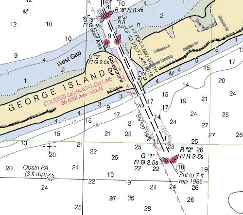
NOAA Chart #11401 - Apalachicola Bay to Cape San Blas is suggested for the approach to Government Cut while NOAA Chart #11401 - NOAA Chart #11402 - Apalachicola Bay to Lake Wimico is suggested for the entrance.
The Gulf Intracoastal Waterway (GIWW) can be intersected 3.6 NM above the entrance at MM "355.4 EHL" in the vicinity of lighted beacon (Fl R 2.5s 17ft 3M "2").
Approach
The approach from the Gulf of Mexico is marked by a pair of buoys (G "1" Fl G 2.5s) and (R "2" Fl R 2.5s), 0.6 NM SSE of the entrance, marking the beginning of the approach channel.
Entrance
The entrance to the cut is protected by twin jetties. There are conflicting reports of depth available in the cut. Some report 7 to 8 feet at high water others report shoaling to a depth of 3 feet. A project depth of 3 feet mid-channel was reported in 2018.
Cautions
Extreme shoaling possible. A dangerous wreck that uncovers was reported 1.0 mile southeast of the approach buoys in about (29°35’14" N / 84°56’43" W). Additionally, a charted obstruction, covered 3 feet, is located 1 NM west of the approach buoys.
Tides & Currents
The mean tidal range is 1.0 feet. Currents through Government Cut have been reported to be as high as 3 to 4 knots.
West Pass
West Pass is the second of the two entrances into Apalachicola Bay. It enters between Sand Island (the northwest tip of Little St. George Island) and St. Vincent Island, 13.1 NM ESE of Cape San Blas and 7.3 NM WNW of Government Cut. It is subject to extreme shoaling, not marked and unreliable for navigation.
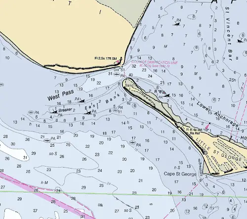
NOAA Chart #11401 - Apalachicola Bay to Cape San Blas is suggested for the approach to West Pass while NOAA Chart #11401 - NOAA Chart #11402 - Apalachicola Bay to Lake Wimico is suggested for the entrance.
The Gulf Intracoastal Waterway (GIWW) can be intersected 7.0 NM above the entrance at MM "355.4 EHL" in the vicinity of lighted beacon (Fl R 2.5s 17ft 3M "2").
Approach
The approach to West Pass is unmarked and is obstructed by a bar with extreme shoaling with depths of 1 to 5 feet with breakers being common; unknown depths, numerous charted and uncharted wrecks, and inadequate navigational marks.
Entrance
The entrance is marked by a single lighted beacon (Fl 2.5s 17ft 5M) with depths of 19 to 40 feet with a submerged wreck mid-channel that may be hazardous to surface navigation.
Cautions
Mariners should use caution when transiting West Pass it is noted to be unreliable for navigation.
There are numerous wrecks, some visible and others submerged with unknown depths, in and around West Pass.
A fan-shaped test firing area projects southward from Little St. George Island, between Government Cut and West Pass.
Tides & Currents
Tidal range in the western portion of Apalachicola Bay is 0.8 feet. Current velocities of 3 knots has been observed in West Pass channel
Indian Pass
Found 5.6 NM miles east of Cape San Blas, Indian Pass enters St. Vincent Sound between Indian Peninsula and St. Vincent Island. Strangers should not attempt to enter this pass.
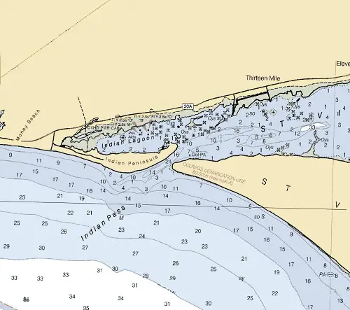
NOAA Chart #11401 - Apalachicola Bay to Cape San Blas is suggested for the approach to Indian Pass while NOAA Chart #11402 - Apalachicola Bay to Lake Wimico is suggested for the entrance.
The Gulf Intracoastal Waterway can be intersected 2.4 NM above the entrance near lighted beacon (Q R 16ft 4M "26") at (MM "9.2").
Approach
The approach and approach channel are unmarked over a bar obstructing the entrance covered 1 to 4 feet.
Entrance
The entrance is unmarked but deep with depths of 7 to 24 feet. The depths inside the entrance shoal to 1 to 3 feet.
Cautions
The approach and entrance are subject to extreme shoaling. The pass is unreliable for navigation and should only be used with local knowledge.
St. Joseph Bay Inlet
Located 14.7 NM NNW of Cape San Blas, St. Joseph Bay is recognized as one of the best harbors on the Gulf. It offers access to Highland View, FL and Port St. Joe, FL as well as the Gulf Intracoastal Waterway. It is easily entered by vessels with drafts to 25 feet except during periods of very severe weather.
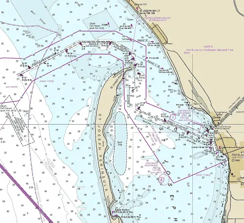
NOAA Chart #11389 - St. Joseph and St. Andrew Bays is suggested for the approach to Port St. Joe while NOAA Chart #11393 - Lake Wimico to East Bay is suggested for the entrance.
Access to the Gulf Intracoastal Waterway is made via the Gulf County Canal which is adjacent to Port St. Joe and provides a connection between St. Joseph Bay and the GIWW. The canal intersects the GIWW near (MM "327.3 EHL") 6.13 miles above St. Joseph Bay. The canal has a controlling depth of 10.1 feet mid-channel in 2018. Near the bay entrance the canal is crossed by a fixed bridge with a clearance of 75 feet.
Approach
The approach from the Gulf of Mexico is marked by lighted buoy (R "2" Fl (2) 5s) located at the beginning of the improved approach channel. The approach channel is well marked with lighted and unlighted buoys and a minimum controlling depth of 29.8 feet mid-channel to the entrance.
Prominent on the approach, is St. Joseph Bay Light (Iso 6s 78ft 13M at 29°55’06"N / 85°22’50"W). Several water tanks are conspicuous at a closer distance inshore.
Vessels should approach the harbor within the Port St. Joe Safety Fairway.
Entrance
A dredged channel leading across 18 foot shoals is well-marked by lighted and unlighted buoys as well as ranges. Federal project depths (2018) are not less than 32 feet in the marked channels.
Cautions
A sunken wreck was reported in the safety fairway in about 29°50’12"N / 85°41’36’W.
A shoal tends to build E from the extremity of St. Joseph Point into the W side of the entrance channel.
Tides & Currents
The mean tidal range in St. Joseph Bay, is about 1.2 feet with strong and erratic crosscurrents being reported at the entrance to St. Joseph Bay NE of St. Joseph Point. These currents are reported to be particularly strong during the ebb. Caution is advised when entering the bay.
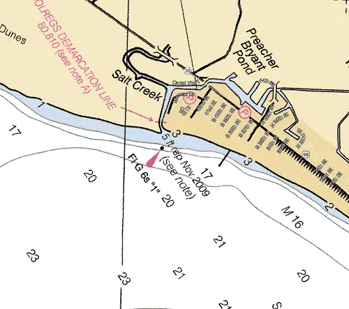
Mexico Beach Canal Entrance
AKA (Preacher Bryant Pond Inlet) Located 5.0 NM NNW of St. Joseph Point is subject to continual shoaling and change. 5 feet of water at the entrance was reported in November 2009. Local knowledge is highly recommended. The entrance is marked by a lighted beacon (Fl G 6s "1"). There is no access to the GIWW.
NOAA Chart #11426 - Estero Bay to Lemon Bay is suggested for the approach to Blind Pass while NOAA Chart #11427 - Fort Myers to Charlotte Harbor is suggested for the entrance.
No access to the GIWW is available through this inlet.
Approach
The approach is marked by Lighted beacon (Fl G 6s “1”) located 0.1 NM south of the entrance. The approach channel is reported to have 5 feet over the bar.
Entrance
The entrance is unmarked with a reported depth of 5 feet. However, the entrance is subject to shoaling.
Cautions
This inlet should not be attempted without local knowledge.
Tides & Currents
The mean tidal range at the Mexico Beach Inlet is ≈1.2 feet.
St. Andrew Sound
Found 10.8 NM NNW of St. Joseph Point and 13.6 NM southeast of St. Andrew Bay Approach Buoy.
There is no access to the GIWW via St. Andrew Sound.
Approach
The approach to St. Andrew Sound is unmarked.
Entrance
The entrance to St. Andrew Sound is unmarked.
Cautions
No recent depth surveys of the approach, entrance, or inside the sound have been conducted. Local knowledge is strongly recommended.
This area may be closed for U.S. Government operations. Contact Tyndall Air Force Base at 850-283-4640 prior to entrance.
St. Andrew Bay Inlet
Located 34.4 NM NW of Cape San Blas and 42.0 NM southeast of Choctawhatchee Bay Approach Buoy. St. Andrew Bay Inlet is through a land cut through Shell Island that forms a passage from the Gulf of Mexico. It affords access to the Grand Lagoon, the GIWW, and Panama City, FL.
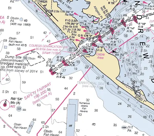
NOAA Chart #11389 - St. Joseph and St. Andrew Bays is suggested for the approach to St. Andrew Bay while NOAA Chart #11391 - St. Andrew Bay is suggested for the entrance.
The Gulf Intracoastal Waterway can be intersected 3.6 NM above the entrance at (MM "290.0 EHL") near Redfish Point in the vicinity of lighted buoy (GR Fl (2+1) G 6s).
Approach
The approach is marked by lighted buoy (RW "SA" Mo (A) at 30°05’30"N., 85°46’26"W) and is fitted with an AIS transponder; lying about 2.2 NM southwest of the entrance channel. Vessels should approach the Inlet through the prescribed Safety Fairways.
The approach channel is deep and well-marked by lighted buoys and a lighted range. Federal project depths are 38 feet to a point just inside the entrance jetties.
Prominent on the approach is a large condominium apartment building, 2.5 miles northwest of the channel entrance. The condominium is reported to be a good radar target at more than 32 miles. Two 130-foot water tanks at Tyndall Air Force Base, about 8.3 NM east-southeast of the entrance. An aeronautical light (rotating white & green) is atop the eastward most tank.
Entrance
The entrance channel is cut through Shell Island, with jetties found on both sides of the entrance. The entrance channel is deep and well-marked by lighted buoys and a lighted range. Federal project depths are 36 feet from the jetties to the bay while charted depths of greater than 44 feet are shown within the entrance.
Submerged jetties extend towards the entrance channel from the northwest and southeast just inside the entrance.
Cautions
One way traffic is required for all large vessels transiting the entrance channel.
Danger zones for small arms firing ranges are southeast of the entrance to St. Andrew Bay.
Submerged jetties extend channelward from the northwest and southeast harbor entrance points. The northwest submerged jetty is unmarked and the southeast submerged jetty is marked by a lighted buoy. Mariners are cautioned to keep within the buoyed channel while navigating the land cut through Shell Island.
Tides & Currents
The range of tide at the St. Andrew Bay Entrance is 1.2 feet. A strong ebb current sets outward through the cut and causes heavy tide rips if the wind is south and of moderate strength. With a south or west breeze, small vessels bound in or out should try to reach the entrance during flood current.
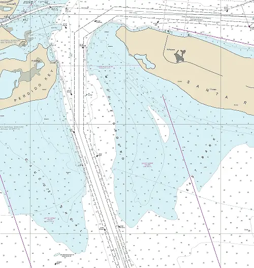
Choctawhatchee Bay Entrance
Lying about 42 NM west-northwest of St. Andrew Bay between Moreno Point and Santa Rosa Island. The entrance is used to access Destin, FL, Ft. Walton Beach, the GIWW as well as the western part of Choctawhatchee Bay.
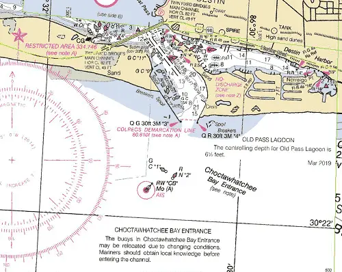
NOAA Chart #11388 - Choctawhatchee Bay is suggested for the approach to St. Andrew Bay while NOAA Chart #11385 - West Bay to Santa Rosa Sound is suggested for the entrance.
The Gulf Intracoastal Waterway can be intersected 3.6 NM above the entrance at (MM "227.7 EHL") near Redfish Point in the vicinity of lighted buoy (GR Fl (2+1) G 6s).
Approach
The approach is marked by buoy (RW “CB” Mo (A) with an AIS transponder at 30°22’14"N / 86°30’56"W), about 0.3 NM off the entrance.
From close offshore the entrance is easily identified by U.S. Route 98 fixed highway bridges crossing the channel just inside the east end of Santa Rosa Island. The parallel bridges have a least clearance of 49 feet
Entrance
is protected by
two jetties. The jetties are marked by a light off their
seaward ends. The entrance is marked by a pair of green and red buoys and is protected by jetties which are marked by lights off their seaward ends. The channel is well marked by lighted and unlighted buoys and beacons with 12+ feet of water mid-channel. Channel buoys are frequently shifted to mark the best water.
Choctawhatchee Bay is restricted by a fixed bridge crossing the head of the pass with a vertical clearance of 49 feet. The GIWW will be intersected via the North Channel 2.5 NM above the entrance at approximately MM "227.7 EHL."
Cautions
Dangers – Due to rapid shoaling, passage during rough weather is not advised.
To carry the best depths, mariners should be guided by the color of the water. Passage should not be attempted in rough weather. Local knowledge is advised.
The channel south of the bridge is subject to frequent changes and shoals rapidly between dredgings. Buoys are frequently shifted to mark best water. The channel is
marked by lights, buoys and daybeacons.
Tides & Currents
The range of tide in Choctawhatchee Bay is 0.5 feet.
Pensacola Bay Entrance
Located 110 NM west-northwest of Cape San Blas and 41.3 NM east of the approaches to Mobile Bay. It affords access to the Gulf Intracoastal Waterway, Santa Rosa Sound, Pensacola, Fl, Pensacola Bay, and East Bay.
NOAA Chart #11382 - Pensacola Bay and Approaches is suggested for the approach to Pensacola while NOAA Chart #11384 - Pensacola Bay Entrance is suggested for the entrance.
The Gulf Intracoastal Waterway can be intersected 0.5 NM above the entrance at (MM "179.7 EHL") near unlighted buoy (G C “1”).
Approach
The approach is marked by the outer two approach channel markers (G "1" Fl G 2.5s) and (R "2" Fl R 2.5s). The approach channel is deep (44 feet mid-channel) and well-marked by lighted and unlighted buoys and a range.
Prominent on the approach is Pensacola Light (30°20’46"N / 87°18’29"W), Fl 20s 191ft 27M, and shown from a conical brick tower, lower third white, upper two-thirds black, on the shore north of the entrance.
Vessels should approach the harbor through the prescribed Safety Fairways.
Entrance
The entrance channel is deep, 40+ feet mid-channel, and well-marked by lighted and unlighted buoys and a lighted range.
Cautions
At night or in thick weather it is well for a vessel uncertain of her position to stay in depths of at least 12 fathoms until the light is sighted or your position is otherwise determined.
East Bank and Middle Ground form an extensive shoal area that extends 1.6 NM south from the west end of Santa Rosa Island.
Caucus Shoal on the east side of the entrance with depths of 2 to 18 feet extends 1.5 NM south from the west side of the entrance. Because of the shoaling on the east side of the entrance, large vessels are advised to navigate as close as possible to the range line.
The wreck of the old battleship USS Massachusetts on the south end of Caucus Shoal is awash and marked by a lighted buoy.
Tides & Currents
The mean tidal range in Pensacola is 1.2 feet. Tidal Currents in Pensacola Bay Entrance in mid-channel is about 1.7 knots at strength, although currents of up to 8 knots have been reported in the entrance and up to 5 knots at the Pensacola Naval Air Station pier.
In Caucus Cut, for 2 hours at the strongest of the ebb, the normal current has a velocity of 2 to 2.5 knots, setting southeast somewhat across the channel in the vicinity of Fort Pickens. The flood has less velocity and sets along the channels. The flood has greater velocity following a norther than at other times.