Whether you are sailing coastwise along New Jersey’s Coast or making use of New Jersey’s Intracoastal Waterway, a number of Entrances, Inlets, or Passes exist between the offshore waters of the Atlantic Ocean and the inland waters.
At last count, in January 2020 there were 14 entrances, inlets, or passes found along the New Jersey coastline. Beginning in the north at the Shrewsbury River Entrance on Raritan Bay to Cape May Inlet to the south all of these inlets provide access to sheltered waters, but only two do not provide access to the New Jersey Intracoastal Waterway.
While many of these entrances and inlets are only suitable for very shallow draft vessels and strong local knowledge, with some closed to navigation. A few can be considered navigable for most vessels. We have listed them below along with useful information on each to aid you in deciding if you wish to use a particular inlet.
Keep in mind when entering any small inlet or entrance on the east coast of the U.S., the best time to enter is on a rising tide with a smooth sea; passage may be hazardous during easterly gales and heavy seas.
Shrewsbury River Entrance
The Shrewsbury River empties through a common entrance with the Navesink River into the southern extremity of Sandy Hook Bay. From the entrance to a point just above the Highlands fixed bridge (61 feet) Federal Project depths of 12 feet or more will be found in the channel, thence 9 feet in Shrewsbury River to the Pleasant Bay Bridge (25 feet) about 7.4 miles above the entrance.
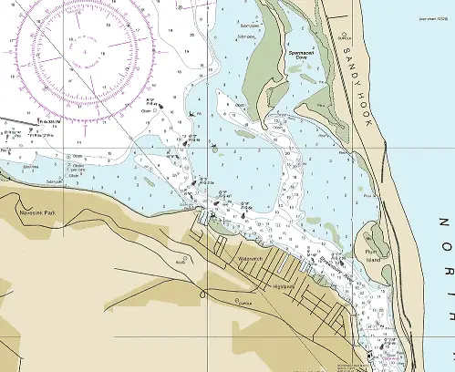
NOAA Chart #12401 - New York Lower Bay is suggested for the approach to Shrewsbury River while NOAA Chart #12325 - Navesink and Shrewsbury Rivers is suggested for the entrance.
There is no access to the NJICW.
Approach
The approach is through Sandy Hook Bay with depths of 16 to 35 feet. The inner approach is surrounded on both sides by shoals covered 1 to 5 feet.
The approach is marked by lighted buoy (R "2" Fl R 4s) and is well marked through to the river entrance by lighted and unlighted buoys.
Prominent on the approach is Sandy Hook Light (F 88ft 19M), Sandy Hook Point Light (Iso 6s 38ft 7M), and Highlands Light (Iso 10s Priv).
Entrance
The entrance is well marked by both lighted and unlighted buoys with depths of 10 to 22 feet with charted shoal spots covered 6 feet or more. A fixed bridge just inside the entrance has a charted vertical clearance of 61 feet.
Cautions:
A submerged stone jetty exists 0.6 NM south of the fixed bridge near the junction with the Navesink River.
Tides & Currents:
Tidal range at the entrance is 4.2 feet. Current velocities range from 2.6 knots at the Highlands Bridge to about 1.6 knots at the Sea Bright Bascule Bridge.
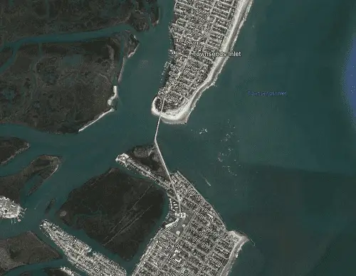
Shark River Inlet
Shark River Inlet, 17 NM south of Sandy Hook Light, is the only small-craft harbor between Sandy Hook and Manasquan Inlet, 5.7 NM further south.
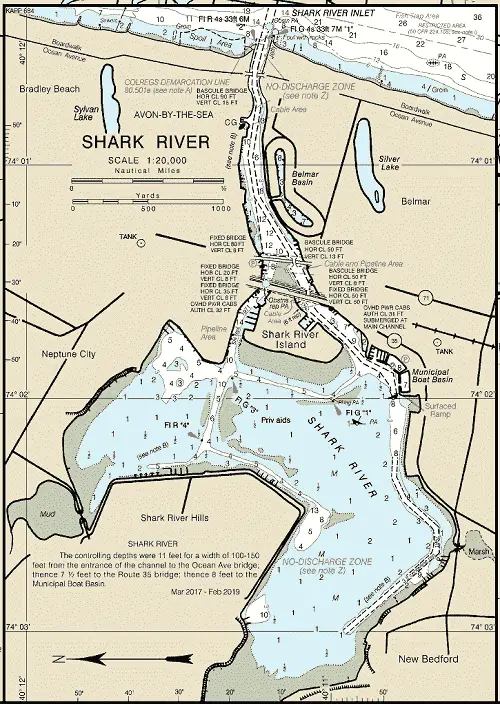
NOAA Chart #12323 - Sea Girt to Little Egg Inlet is suggested for the approach to Shark River Inlet while NOAA Chart #12324 - Sandy Hook to Little Egg Harbor is suggested for the entrance.
There is no access to the NJICW.
Approach
There is no outer approach mark to Shark River Inlet, but the approach from any easterly quadrant is deep with depths of 22 to 50+ feet and free from hazard.
Entrance
The entrance to Shark River is a dredged channel showing a controlling depth of 11 feet in 2013. It is protected by jetties to the north and south. The jetties are marked by lights near the outer ends. The north jetty is marked by a lighted beacon (Fl R 4s 33ft 6M "2") the south jetty shows a lighted beacon (Fl G 4s 33ft 7M "1"). The channels inside the entrance are reported to have a minimum of 7.5 feet controlling depth.
Cautions
In stormy weather, breakers form along the bar off the inlet, but entrance can be made in moderately rough weather with some local knowledge. When the winds and the tides are opposed, the inlet is difficult to enter. A cross current, strongest on the ebb, may be encountered at Ocean Avenue Bascule Bridge (15 feet) at the inner end of the jetties. Vessels for which the closed bridge clearance is insufficient should not attempt entrance until the bridge is completely open.
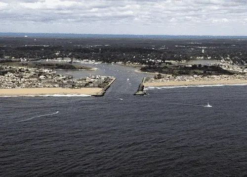
Manasquan Inlet
Manasquan Inlet, located 5.7 NM south of Shark River Inlet and 21.2 NM north of the Barnegat Inlet Approach Buoy. It is the northern terminus of the New Jersey Intracoastal Waterway.
NOAA Chart #12323 - Sea Girt to Little Egg Inlet is suggested for the approach to Manasquan Inlet while NOAA Chart #12324 - Sandy Hook to Little Egg Harbor is suggested for the entrance.
NJICW (MM "0.0").
Approach
The approach to Manasquan Inlet is marked by Lighted Buoy (R "2M" Fl R 4s) located 1.0 NM southeast of the entrance at (40°05’32" N / 074°00’48" W). The approach from the eastern quadrants is deep with depths of 15 to 50 feet to the entrance jetties and shows no charted hazards.
Entrance
Manasquan Inlet is a dredged channel showing a charted depth of 11 feet in 2013. It is protected by jetties to the north and south. The jetties are marked by lights near the outer ends. The north jetty is marked by a lighted beacon (Fl R 4s 30ft 8M "4") the south jetty shows a lighted beacon (Fl G 6s 35ft 8M "3" Horn (MRASS)). The least controlling depth inside the entrance is reported to be 7.5 feet mid-channel to the Pt. Pleasant Canal.
Cautions
Traffic conditions in Manasquan Inlet can be hazardous due to the large volume of commercial and pleasure boat traffic. Mariners should exercise caution when entering Manasquan Inlet when the winds and tides are opposed; local knowledge is advised.
Tides & Currents
The mean tidal range for Manasquan Inlet is approximately 4.0 feet. The current velocity is about 1.8 knots in the inlet entrance.
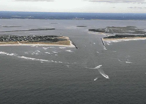
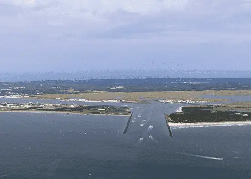
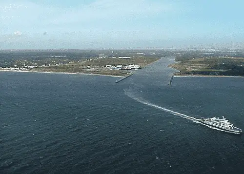
Barnegat Inlet
Barnegat Inlet, 21 miles southward of Manasquan Inlet, forms a passage from the Atlantic Ocean through Oyster Creek Channel to the New Jersey Intracoastal Waterway and Barnegat Bay.
NOAA Chart #12323 - Sea Girt to Little Egg Inlet is suggested for the approach to Barnegat Inlet while NOAA Chart #12324 - Sandy Hook to Little Egg Harbor is suggested for the entrance.
The NJICW can be intersected 5.2 NM above the entrance at (MM "26.0") near lighted buoy (R "42" Q R).
Approach
The approach to the inlet is marked by lighted buoy (RW "BI" Mo(A) Whis) about 1.7 NM southeast of the north jetty.
The approach is deep with a least charted depth of 33 feet to within 0.7 NM of the entrance where a shifting bar with depths of 11 to 17 feet covers the entrance. Approach channel buoys are uncharted due to being frequently shifted to mark the best water.
Prominent on the approach is Barnegat Light (39°45’51" N / 74°06’22" W), on the south side of the inlet. Also prominent from seaward is a 391 foot high power plant stack at the head of Oyster Creek, on the west side of Barnegat Bay.
Entrance
The entrance is protected by jetties to the north and south. The north jetty is marked by a lighted beacon (Q R 40ft 5M "6") as well as two Danger Buoys (White and Orange Cans) are used to mark the submerged portion of the jetty; the south jetty shows a (Q G 35ft 5M "7"). The entrance is marked by uncharted buoys that are moved frequently to mark the best water.
Cautions
Barnegat Inlet Channel is subject to continual change and severe shoaling. Oyster Creek Channel is also subject to continual change and severe shoaling. The buoys marking these channels are shifted frequently to mark the best water and therefore are not charted. North Jetty is partially submerged. It was reported that various aids marking Oyster Creek Channel may be submerged because of strong tidal currents. Breakers are often found in the entrance and across the approach with an ebb tide and an easterly wind.
Strangers should not attempt to transit the inlet under any but ideal conditions.
Tides & Currents
Mean tidal range for Barnegat Inlet is approximately 4.2 feet. The current velocity in Barnegat Inlet is about 2.5 knots in the inlet, although currents as high as 7 knots have been reported.
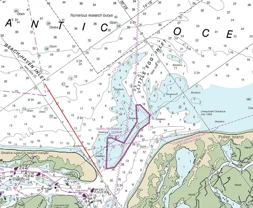
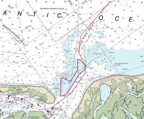
Beach Haven Inlet
Beach Haven Inlet is found 17 miles south-southwestward of Barnegat Inlet; it is unmarked. The entrance to Beach Haven Inlet should not be mistaken for Little Egg Inlet.
NOAA Chart #12323 - Sea Girt to Little Egg Inlet is suggested for the approach to Beach Haven Inlet while NOAA Chart #12316 - Little Egg Harbor to Cape May is suggested for the entrance.
The New Jersey Intracoastal Waterway can be intersected just inside the entrance near lighted buoy (GR "LEI" Fl (2+1) G 6s) at (MM "51.2").
Approach
The approach to Beach Haven should be made from the NNE through the East to remain clear of any hazards. The approach is unmarked, but generally free from dangers with depths ranging from 11 to 17 feet until within 1.5 NM of the entrance.
Entrance
The entrance to Beach Haven Inlet is unmarked, narrow, and has depths ranging from 3 to 6 feet. For most, this inlet should be considered un-navigable by anyone with out strong local knowledge. Do not be mistake Beach Haven Inlet for Little Egg Inlet, which is very close southward.
Cautions
Numerous uncharted wrecks and shoal spots exist in the entrance. Due to changing conditions of the channel, boatmen are advised to seek local knowledge prior to entering. The bar at the mouth of the inlet with depths of 2 feet and less breaks in all but the most calm of seas.
Tides & Currents
The mean tidal range in Beach Haven Inlet is 3.2 feet.
Little Egg Inlet
Little Egg Inlet is located 19 NM south-southwestward of Barnegat Inlet and close southward of Beach Haven Inlet. It affords access to Beach Haven and Tuckerton, NJ as well as Little Egg Harbor.
NOAA Chart #12323 - Sea Girt to Little Egg Inlet is suggested for the approach to Little Egg Inlet while NOAA Chart #12316 - Little Egg Harbor to Cape May is suggested for the entrance.
The New Jersey Intracoastal Waterway can be intersected just inside the entrance near lighted buoy (GR "LEI" Fl (2+1) G 6s) at (MM "51.2").
Approach
The approach to Little Egg is unmarked, but generally free from dangers with depths ranging from 22 to 40+ feet until at the outside of the bar. The inner approach channel is marked with uncharted buoys that are moved frequently to mark the best water. Depths over the bar vary from 1 to 28 feet with ample depth in the marked channel. The approach is bordered by breakers and bare shoals on both sides.
Entrance
The entrance deepens until well inside. The entrance is well marked, but due to the inlet channels and shoreline constantly changing, the buoys are not charted because they are frequently shifted in position. Depths range from 12 to 44 feet.
Cautions
Numerous uncharted wrecks and shoal spots exist in the entrance. An unmarked partially submerged wreck was reported at about 39°29’09" N / 74°17’31" W; caution is advised. Due to changing conditions of the channel, mariners are advised to seek local knowledge prior to entering. In very heavy weather breakers form all the way across the entrance bar.
Tides & Currents
The mean tidal range in Little Egg Inlet is 3.2 feet.
Brigantine Inlet
Brigantine Inlet, 2.6 miles south-southwestward of Little Egg Inlet, has shoaled to such an extent that it is unsafe for even the shallowest drafts. Brigantine Shoal, 3 miles south of the inlet, has a least depth of 18 feet.
Absecon Inlet
Absecon Inlet is located 8.7 miles southwestward of Little Egg Inlet and 7.7 NM northeast of the Great Egg Harbor Inlet. It provides access to Atlantic City and Brigantine, NJ.
NOAA Chart #12318 - Little Egg Inlet to Hereford Inlet is suggested for the approach to Little Egg Inlet while NOAA Chart #12316 - Little Egg Harbor to Cape May is suggested for the entrance.
The New Jersey Intracoastal Waterway can be intersected 1.9 NM above the inlet entrance at (MM "65.1") near lighted beacon (Q R 15ft 4M "182").
Approach
The outer approach is marked by a pair of lighted buoys (G "1" Fl G 4s) and R "2" Fl R 2.5s) approximately 1.1 NM SSE of the end of the south jetty. The approach depth ranges from 21 to 34 feet mid-channel and is reasonably well marked by lighted buoys.
Prominent on the approach are large buildings to the south of the inlet. These building can be seen well offshore at night.
Entrance
The inlet is protected at the entrance by unmarked jetties and a revetment extends along the Atlantic City side of the inlet.
The entrance is deep and well-marked, but the channel is subject to continual change and the buoys are frequently shifted to mark the best water. A fixed bridge, 1.5 NM above the entrance crosses the head of the inlet with a vertical clearance of 60 feet.
Cautions
Care must be exercised when passing through the fixed bridge because of the strong currents. Velocities of 2.5 knots have been reported. Brigantine Shoal, 1.7 NM northeast of the entrance with depths of 5 to 17 feet.
Tides & Currents
The mean tidal range in Absecon Inlet is 4.0 feet. Currents on average run about 2.5 knots, however velocities up to 6 knots have been reported in the inlet channel.
Great Egg Inlet
Great Egg Harbor Inlet is located 7 NM southwest of Absecon Inlet and 25.4 NM northeast of Cape May Inlet is subject to continual change due to severe shoaling. It allows access to Longport, Ocean City, and Somers Point, NJ as well as the NJICW.
NOAA Chart #12318 - Little Egg Inlet to Hereford Inlet is suggested for the approach to Little Egg Inlet while NOAA Chart #12316 - Little Egg Harbor to Cape May is suggested for the entrance.
The New Jersey Intracoastal Waterway can be intersected at (MM "79.2") near buoy (R N "250A") approximately 1.3 NM above the entrance.
Approach
The approach is unmarked with a bar that partially oscure the entrance. The buoys marking the approach channel are not charted because they are shifted frequently to mark the best water. The approach is deep with depths of 11 to 30+ feet. Shoals with depths of 3 to 5 feet and breakers line both sides of the approach.
Entrance
The entrance is likewise deep with depths ranging from 11 to 40+ feet. Similar to the approach, the buoys marking the entrance are not charted because they are shifted frequently to mark the best water. Breakers occur often on the west side of the entrance.
Cautions
Breakers extend along the bar even in moderate weather and are hazardous to small boats. Local knowledge is advised at all times when using this inlet.
Tides & Currents
The mean tidal range of tide is 3.8 feet in the inlet.
Corson Inlet
Corson Inlet is found 14 NM southwest of Absecon Inlet and 19.1 NM NNE of Cape May Inlet, it is unmarked and subject to constant change in depth. It is considered to be unnavigable. The entire entrance breaks in moderate weather with depths of 1 foot to bare found in the entrance. Closed To Navigation!
Townsends Inlet
Townsends Inlet is found 20 NM southwest of Absecon Inlet and 14 NM northeast of Cape May Inlet. It provides access to Sea Isle City, Avalon, NJ, and the NJICW. It is used principally by pleasure craft.
NOAA Chart #12318 - Little Egg Inlet to Hereford Inlet is suggested for the approach to Little Egg Inlet while NOAA Chart #12316 - Little Egg Harbor to Cape May is suggested for the entrance.
The New Jersey Intracoastal Waterway can be intersected at (MM "96.3") near buoy (R "372" Q R) approximately 1.0 NM above the south jetty.
Approach
The approach is marked by lighted buoy (R "4A" Fl R 4s BELL) located at 39°05’23" N / 074°33’57" W; approximately 1.4 NM NE of the south jetty. A large shoal area with depths of 1 to 6 feet obstructs the approach from the northeast. The approach channel is marked by uncharted buoys that are shifted frequently to mark the best water. Charted depths show good water with depths of 8 to 17 feet in the approach channel as far as the bridge.
Hereford Inlet
Hereford Inlet is located 28 miles southwest of Absecon Inlet and 5.6 NM northeast of Cape May Inlet affords access to Stone Harbor and Wildwood, NJ as well as the NJICW. It is considered unnavigable to strangers and only seasoned and experienced locals tend to use the inlet.
NOAA Chart #12318 - Little Egg Inlet to Hereford Inlet is suggested for the approach to Little Egg Inlet while NOAA Chart #12316 - Little Egg Harbor to Cape May is suggested for the entrance.
The NJICW can be Intersected 1.5 NM above the entrance at (MM "104.4") near lighted beacon (Q R "436" 4M).
Approach
The approach to Hereford inlet is not marked. Although generally free from hazards until reaching the bar obstructing the entrance. The approach channel is reported marked with uncharted buoys that are frequently moved to mark the best water over the constantly changing bar.
Prominent on the approach is Hereford Inlet Light (Fl 10s 57ft 18M) located at 39°00’24" N / 74°47’28" W.
Entrance
The entrance is subject to rapid changes and breakers form at all times on the bar and shoals across the inlet. The upper end of the entrance is crossed by a bascule bridge with 15 feet clearance in the closed position.
Cautions
A shoal in the middle of the approach to the inlet that bares at low water. This shoal breaks even in moderate weather. The approach to the inlet is extremely dangerous with a following sea.
Tides & Currents
A mean tidal range of tide is 4.1 feet is found in the inlet.
Cape May (Cold Spring) Inlet
Cape May Inlet is found 34 miles southwest of Absecon Inlet and 12.3 NM northeast of the main entrance to the Delaware Bay. It provides access to Wildwood and Cape May, NJ as well as the NJICW and the Cape May Canal.
NOAA Chart #12214 - Cape May to Fenwick Island is suggested for the approach to Little Egg Inlet while NOAA Chart #12317 - Cape May Harbor is suggested for the entrance.
The New Jersey Intracoastal Waterway can be intersected at (MM "112.7") near lighted beacon (Q R 13ft 5M "4").
Approach
The approach to Cape May Inlet is marked by lighted buoy (R "2CM" Fl R 2.5s) located at 38°55’47" N / 074°51’21" W approximately 0.6 NM SE of the entrance.
The approach is deep with depths of 24 to 37 feet and it is free from any hazards.
Conspicuous from well offshore are the lights on the abandoned LORAN tower on the northeastern side of the inlet and Cape May light (Fl 15s 165ft 22M) southwestward of the approach course.
Entrance
The entrance is protected by jetties to the northeast and southwest and are marked with lighted beacons being shown from the ends. The northeastern jetty displays (Fl R 4s 25ft 6M "4") and the southwestern jetty (Fl G 4s 38ft 6M "5").
The entrance is deep with mid-channel charted depths ranging from 19 to 100 feet. It is marked with range lights as well as lighted beacons and buoys at its upper end.
From the inner portion of the entrance a channel marked by lights and daybeacons leads west through Cape May Harbor then divides north to the mouth of Cape May Canal and south to the mouth of Schellenger Creek. Another channel to the northeast (NJICW) leads to Wildwood, NJ with depths of 11 to 20 feet.
Cautions
A United States Coast Guard rifle range extends out approximately 0.8 NM from the shoreline and 0.8 NM westward from Sewell Point to approximately 0.8 NM from the Cape May Inlet.
Tides & Currents
The mean range of tide is 3.3 feet in the inlet. Tidal currents average around 1.6 knots in the inlet.
Cape May Canal Inlet (West)
The Cape May Canal western entrance is from the Delaware Bay and is the southern terminus of the New Jersey Intracoastal Waterway (MM "117.7"). It provides access to Cape May Harbor and the town of Cape May, NJ.
NOAA Chart #12304 - Delaware Bay is suggested for the approach to the Cape May Canal while NOAA Chart #12316 - Little Egg Harbor to Cape May is suggested for the entrance.
The NJICW is found at the entrance jetties (MM "117.7").
Approach
The approach is obstructed by (2) separate bars. The outer bar beginning 2.1 NM westward of the entrance is covered by depths of 9 to 16 feet and is unmarked. The approach buoy (R "8" Fl R 2.5s) is located at 38°57’59" N / 74°58’46" W. The inner bar located at the entrance is covered 11 to 17 feet.
Prominent on the approach is Cape May light (Fl 15s 165ft 22M).
Entrance
The entrance is protected by stone jetties to the north and south and located 2.0 NM north of Cape May Light. The outer ends of the jetties are marked by lighted beacons; the north jetty beacon showing (Fl G 2.5s 34ft 6M "11" HORN (MRASS)). The southern jetty is marked by a (Fl R 4s 30ft 6M "10")
The entrance channel is poorly marked and shallow. Depths from a 2013 survey by the Army Corp of Engineers showed 4.1 feet mid-channel.
Cautions
Vessels should avoid overtaking or meeting ferries while they are transiting the entrance to the canal or turning to their berths on the north side of the canal.
Choppy seas are reported to form on Delaware Bay when the wind and tidal currents are opposed; it is especially hazardous at the entrance to Cape May Canal. Large waves may form within the canal during periods of strong northwesterly winds.
Two submerged dolphins, hazardous to navigation, are on the southern edge of the channel on the west side of the State Route 162 Bridge.
Tides & Currents
Approach
The mean tidal range at the Cape May Canal Entrance is 4.7 feet with typical current velocities of 1.9 knots at the east end and 0.9 knot at the west end.