Whether you are sailing coastwise along Virginia’s Coast or making use of the Atlantic Intracoastal Waterway, a number of Entrances, Inlets, or Passes exist between the offshore waters of the Atlantic Ocean and the inland waters of Virginia.
At last count, in January 2020 there were 13 entrances, inlets, or passes found along the east coast of Virginia. Beginning in the north at Chincoteague Inlet on Virginia’s Eastern Shore to Rudee Inlet in Virginia Beach to the south all of these inlets provide access to sheltered waters, but only one provides direct access to the Atlantic Intracoastal Waterway.
While many of these entrances and inlets are only suitable for very shallow draft vessels and strong local knowledge, with some also closed to navigation. A few can be considered navigable for most vessels. We have listed them below along with useful information on each to aid you in deciding if you wish to use a particular inlet.
The principal entrance on the Virginia Coast is the "Entrance to the Chesapeake Bay" which allows access to the Atlantic Intracoastal Waterway. The remaining 12 inlets provide no access to the AICW.
Keep in mind when entering any small inlet or entrance on the east coast of the U.S., the best time to enter is on a rising tide with a smooth sea; passage may be hazardous during easterly gales and heavy seas.
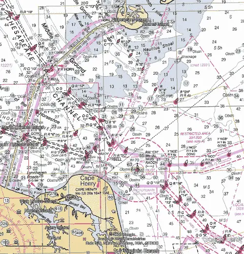
Chesapeake Bay Entrance
The Chesapeake Bay entrance is located 233.6 NM SSW of the entrance to New York and 314.6 NM NNE of Charleston, SC. The mouth of the bay is 9.5 NM wide and for the most part deep. The Chesapeake Bay Entrance is also the only entrance on the Virginia Coast that intersects the Atlantic Intracoastal Waterway.
NOAA Chart #12221 - Chesapeake Bay Entrance is suggested for the approach to the Chesapeake Bay while NOAA Chart #12222 - Cape Charles to Norfolk Harbor is suggested for the entrance.
The Approach
There are (2) established approaches to the Chesapeake Bay, both through typical Traffic Separation Schemes:
- The Northeastern Approach is recommended for vessels drawing less than 42 feet and is marked by buoy (Y "NCA" Fl Y 2.5s BELL) located 9.3 NM east-northeast of the entrance at 36°57’30" N / 075°48’13" W. This approach is well marked by lighted yellow fairway buoys.
- The Deep-Water Approach is marked by buoy (RW "CB" Mo (A) WHIS RACON (— · —) AIS) located 15.9 NM southeast of the entrance at 36°49’00’ N / 075°45’36’ W. This is most often used by vessels approaching from the south and east or vessels with drafts of 42 feet or more.
Both established approaches converge on the inner approach buoy, (RW "CH" Mo (A) WHIS RACON (–·–·) AIS) located 2.3 NM ESE of the entrance at 36°56’08" N / 075°57’27" W. Exercise extreme caution where the two approach routes converge off of Cape Henry for vessels that may be maneuvering in the vicinity.
From the inner approach mark, (2) channels are available:
- Cape Henry/Chesapeake Channel which leads north up the Chesapeake Bay to the Potomac River and Washington, DC, Annapolis, MD, Baltimore, MD, the C&D Canal, and the head of the bay. It begins 2.3 NM NNE of Cape Henry Light and extends 10.1 NM northwestward where it splits becoming York Spit Channel leading up the bay.
- Thimble Shoal Channel which leads westward to Little Creek, Hampton Roads, Norfolk, Newport News, and the northern most terminus of the Atlantic Intracoastal Waterway. It begins 1.7 NM northwest of Cape Henry Light and extends 9.5 miles west-northwestward. A Federal project provides for a 55-foot-deep channel with a 32-foot-deep auxiliary channel on each side of the main channel. Thimble Shoal Channel is a regulated navigation area and draft limitations apply. A vessel drawing less than 25 feet may not enter the channel, unless the vessel is crossing the channel.
Prominent on the Approaches
- Chesapeake Light (2 Fl W 4s 84ft 5M Priv) nearly in the center of the bay entrance (2) is shown from a blue tower on a white superstructure on four piles, 13.9 NM miles eastward of the entrance at 36°54’17" N., 75°42’46" W. . The name "CHESAPEAKE" is displayed on all sides.
- Cape Henry Light (Mo U [··–] 20s 164ft 15M) on the south side of the Chesapeake Bay Entrance, (36°55’35" N., 76°00’26" W.), is shown from an octagonal, pyramidal tower, upper and lower half of each face alternately black and white, on the beach near the turn of the cape.
The approach is marked by buoy (RW "CH" Mo (A) WHIS RACON (–·–·) AIS) located 2.3 NM ESE of the entrance at 36°56’08" N / 075°57’27" W.
Cautions:
The Chesapeake Bay Bridge-Tunnel complex has on several occasions suffered damage from vessels. In every case, adverse weather prevailed with accompanying strong winds from the northwest quadrant generally related to a frontal system. Weather deterioration in the lower bay is quite often sudden and violent and constitutes an extreme hazard to vessels operating or anchoring in this area. The proximity of the bridge-tunnel complex to main shipping channels and anchorages adds to the danger. Currents in excess of 3.0 knots can be expected in the area.
Local Magnetic Disturbance Differences of as much as 6° from the normal variation have been observed 3 to 17 miles offshore from Cape Henry to Currituck Beach Light.
A Naval Restricted Area extends northward and eastward from Cape Henry. (See 33 CFR 334.320 for limits and regulations.
Nautilus Shoal with a least depth of 7 feet over on the northern side of the entrance.
Inner Middle Ground frequently has Breakers occurring along the axis of the shoal. Starting on the seaward side of the Chesapeake Bay Bridge-Tunnel and continuing the entire length of the shoal. This phenomenon appears to be associated with large swells rolling in from sea from the south-southeast to southeast.
Tides and Currents:
Mean Tidal Range is 3.1 feet at Cape Henry, 2.4 feet in Hampton Roads, and 2.6 feet at Craney Island. Current velocities are 1.0 knots on the flood and 1.5 knots on the ebb at the Chesapeake Bay Entrance.
Rudee Inlet
Rudee Inlet is located at the southern end of Virginia Beach, about 6.4 NM south of the Chesapeake Bay Entrance and 64.7 NM North-Northwest of Oregon Inlet.
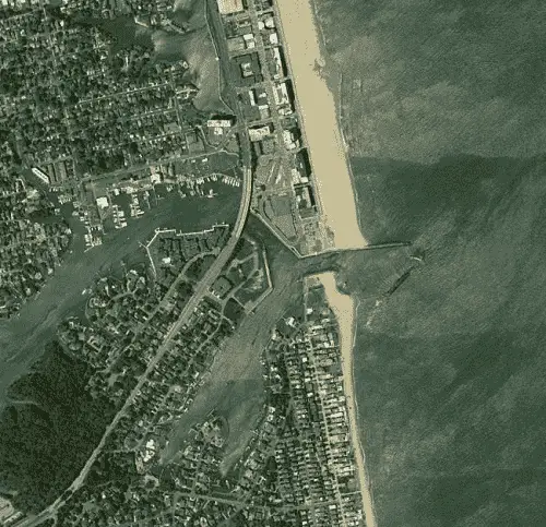
NOAA Chart #12207 - Cape Henry to Currituck Beach Light is suggested for the approach to Rudee Inlet while NOAA Chart #12205 - Cape Henry to Pamlico Sound is suggested for the entrance.
The approach is marked by a lighted buoy (RW "RI" Mo(A) WHIS) located 0.8 NM east of the entrance at 36°49’47" N / 075°56’57" W. The approach is deep (20+ feet until the entrance channel outer buoys.
Prominent on the approach are (2) radar towers and a blue water tank about 1 NM southward of Rudee Inlet.
The entrance is protected by two jetties with a dredged channel leading between the jetties and is marked by lighted buoys and a lighted beacon on the outer end of the north jetty. It leads to a basin just inside the jetties, thence westward to a safety area about 0.2 mile above the jetties, thence northwestward to Lake Rudee or southwestward to Lake Wesley. While dredging operations attempt to maintain Rudee Inlet channel to a depth of 10 feet, the inlet is subject to continual shoaling.
Two fixed highway bridges, an east span and a west span, both with a clearance of 28 feet, restrict access to Lake Rudee. Lake Wesley has no clearance restrictions with depths of 8 to 22 feet.
Rudee Inlet offers no access to the Atlantic Intracoastal Waterway.
Cautions:
Local Magnetic Disturbance with differences of as much as 6° from the normal variation have been observed 3 to 17 miles offshore from Cape Henry to Currituck Beach Light.
A Naval Restricted Area extends northward, eastward and southeastward from Cape Henry.
A Naval Prohibited Area is off Camp Pendleton, 7.4 miles southward of Cape Henry.
Firing Range Danger Zones are between 7 and 9 miles southward of Cape Henry.
Tides & Currents
Mean tidal range at the entrance to Rudee Inlet is 3.3 feet.
While offering no access to the Atlantic Intracoastal Waterway, we have listed below the inlets along Virginia’s Eastern Shore.
While most of these inlets are shallow and many are hazardous requiring strong local knowledge to enter; all of them will require careful navigation. That being said, a couple do offer refuge from the storm, if entered early.
Chincoteague Inlet
Chincoteague Inlet lying between Assateague Island and Wallops Island, is 30 miles south-southwestward from Ocean City, MD Inlet.
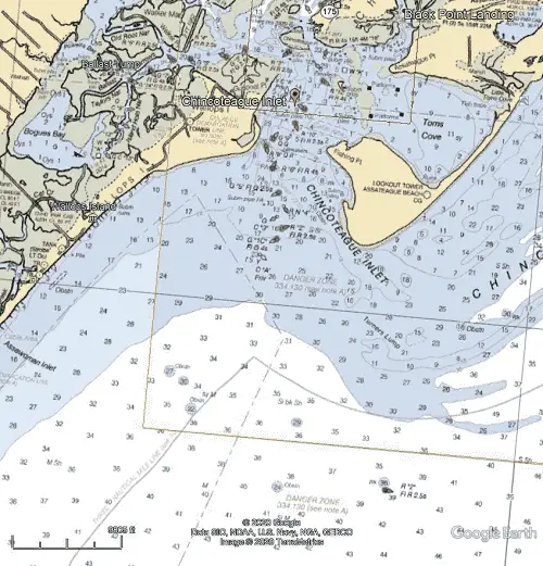
NOAA Chart #12210 - Chincoteague Inlet to Great Machipongo Inlet is suggested for the approach and entrance to Chincoteague Inlet.
The approach has no sea buoy, however lighted buoy (R "2" Fl R 2.5s), marking Chincoteague Shoals, is located 5.2 NM ESE of the entrance at 37°47’25" N / 075°22’21" W can be used.
Prominent on the approach are Assateague Light (Fl (2) 5s 154ft 22M) is shown from a 142-foot red and white horizontally banded conical tower and a lookout tower on the southern tip of Assateague Island; both are visible well offshore.
The marked channel through the inlet to Chincoteague Channel is subject to frequent change; the buoys are shifted with changing conditions. Breakers are evident on either side of the channel. A sunken wreck is about 0.4 mile southwest of Fishing Point in 37°51’54" N., 75°24’04" W.
Cautions
Chincoteague Shoals, extending about 3 NM east and south of the lower end of Assateague Island, with a least depth of 8 feet. Breakers are evident on either side of the channel and a sunken wreck is about 0.4 mile southwest of Fishing Point in 37°51’52" N., 75°24’03" W. Caution is advised when navigating this inlet.
Tides and Currents
Mean tidal range at the entrance is about 2.2 feet. With strong winds of long duration, depths may be as much as 3 feet above or below the normal level.
Gargathy Inlet
Closed To Navigation! Unmarked with entrance depths of less than 1 foot across the mouth of the inlet.
Metompkin Inlet
Metompkin Inlet, the ocean entrance between Metompkin Islands and Cedar Island, is used by some small local fishing and oyster boats. The changeable entrance channel is unmarked and should not be entered without local knowledge.
NOAA Chart #12210 - Chincoteague Inlet to Great Machipongo Inlet is suggested for the approach to Metompkin Inlet Inlet. No large scale entrance chart is available.
Wachapreague Inlet
Wachapreague Inlet is found between Cedar Island and Parramore Island, 20 NM south-southwestward of Chincoteague Inlet.
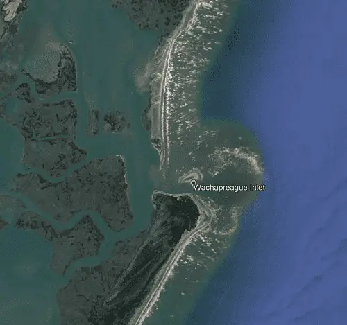
NOAA Chart #12210 - Chincoteague Inlet to Great Machipongo Inlet is suggested for the approach to Wachapreague Inlet. No large scale entrance chart is available.
The Approach
The approach is marked by a lighted buoy (RW "W" Mo(A) WHIS) located 3.0 NM east of the entrance at 37°34’54" N / 075°33’37" W.
The approach and entrance are marked by uncharted buoys and beacons due to being shifted frequently to mark the best water.
Cautions
Wachapreague Inlet should only be entered with local knowledge.
Tides and Currents
Mean tidal range at the entrance is about 3.8 feet.
Quinby Inlet
Quinby Inlet, lies between Parramore Island and Hog Island, has a fan of breakers across the bar at the entrance. Buoys marking the channel through the inlet are frequently shifted in position and not charted. The inlet should not be used without local knowledge.
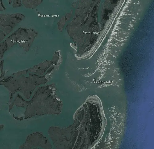
NOAA Chart #12210 - Chincoteague Inlet to Great Machipongo Inlet is suggested for the approach to Quinby Inlet. No large scale entrance chart is available.
Great Machipongo Inlet
Great Marchipongo Inlet leads between Hog Island and Cobb Island, 16.8 NM SSW of Wachapreague Inlet, to Great Machipongo Channel. Shoals on either side of the entrance are marked by breakers at all times; the bar breaks only in heavy weather. The inlet is marked by buoys that are shifted in position with changing channel conditions.
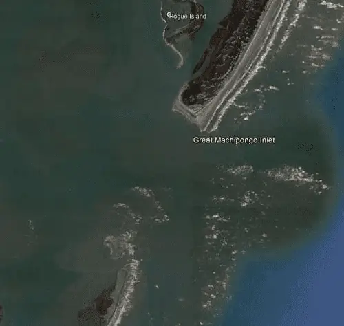
NOAA Chart #12210 - Chincoteague Inlet to Great Machipongo Inlet is suggested for the approach to Great Machipongo Inlet. No large scale entrance chart is available.
Sand Shoal Inlet
Sand Shoal Inlet, the ocean entrance between Cobb Island and Wreck Island, may be entered through three channels. Northeast Channel leads along the south end of Cobb Island, Southeast Channel and South Channel just east of Wreck Island. The bar over Southeast Channel breaks in heavy weather. These channels are subject to continual change and strangers should seek local knowledge before transiting through the inlet.
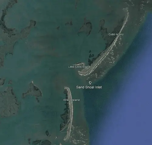
NOAA Chart #12221 - Chesapeake Bay Entrance is suggested for the approach to Sand Shoal Inlet. No large scale entrance chart is available.
New Inlet
Closed To Navigation! Unmarked with entrance depths of 3 feet or less across the mouth of the inlet.
Ship Shoal Inlet
Ship Shoal Inlet, the ocean entrance between Ship Shoal Island and Myrtle Island, is shallow and unmarked; it is used only by local oyster boats. There is deep water back of the inlet, but the channels to the inside passages are shallow and tortuous.
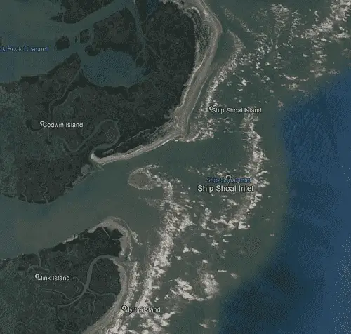
NOAA Chart #12221 - Chesapeake Bay Entrance is suggested for the approach to Ship Shoal Inlet. No large scale entrance chart is available.
Little Inlet
Little Inlet, between Myrtle Island and Smith Island, is shallow and is little used. Small boats can connect with the inside passage at high water.
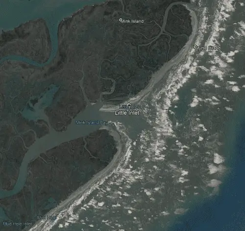
NOAA Chart #12221 - Chesapeake Bay Entrance is suggested for the approach to Little Inlet. No large scale entrance chart is available.
Smith Island Inlet
Smith Island Inlet, between Smith Island and Fishermans Island, is fairly wide, but the narrow, changeable channel lies between sandbars and breakers. The inlet is used by many local boats with drafts of 3 to 4 feet, but it is unmarked and should not be used by strangers. The controlling depth over the bar is said to be 1.5 feet.
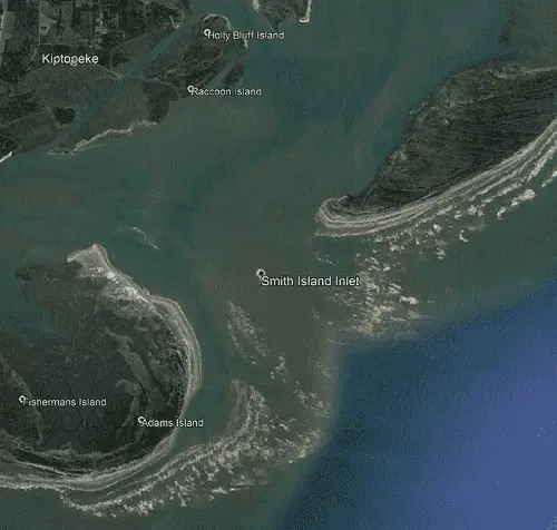
NOAA Chart #12221 - Chesapeake Bay Entrance is suggested for the approach to Smith Island Inlet. No large scale entrance chart is available.