There are approximately 32 Ocean Entrances, Inlets, or Passes along the coastline of South Carolina at last count. Starting with Little River Inlet in the north to Port Royal Sound to the south, many provide access to sheltered inland waters and quite a few provide access to the Atlantic Intracoastal Waterway.
While most of these are only suitable for shallow draft vessels and/or local knowledge, many should be considered as un-navigable, and some considered navigable for most vessels. We have listed most of them below along with useful information on each to aid you in deciding if you wish to use a particular inlet.
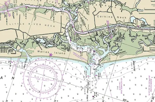
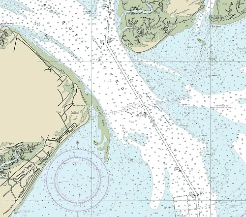
Little River Inlet
The entrance to Little River Inlet is about 24.7 NM west of the Cape Fear River Entrance approach buoy. Located between Bird Island to the east and Waties Island to the west, it affords access to the AICW and Little River, SC.
The approach is marked by a lighted buoy (RW "LR" Mo(A)) located 1.2 NM south of the entrance at 33°49’49" N / 078°32’27" W.
The approach is over a bar with a least charted depth of 10 feet mid-channel. The bar channel is subject to continual change and the buoys marking it are shifted frequently to mark the best water and are not charted.
Entrance
The entrance is protected by jetties with lighted beacons just off the ends. The entrance channel is marked by lighted and unlighted charted buoys. The entrance has a charted least depth of 14 feet until well inside.
The junction of the Atlantic Intracoastal Waterway is 2.3 NM above the entrance at (MM "340.7") near lighted beacon (Fl G 4s 15ft 4M "119").
Cautions
The buoys and daybeacons at Little River Inlet are not charted because they are frequently shifted to mark the best water. Extreme caution is advised when entering and leaving the inlet.
Several dangerous wrecks are south and west of the entrance. There is a large sand bar covered 5 feet just off the eastern jetty.
Tides & Currents
Mean tidal range at the inlet is about 5 feet.
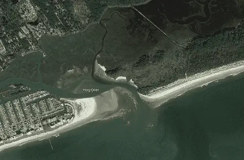
Hog Inlet
Hog Inlet, located 2.4 NM west of Little River Inlet, should be considered as not navigable except for vessels drawing less than 3 feet and dead calm weather.
NOTE: There is no access to the Atlantic Intracoastal Waterway.
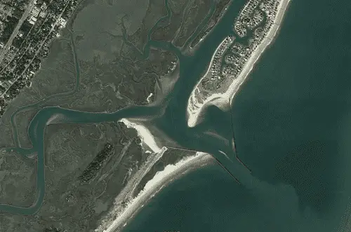
Murrells Inlet
Murrells Inlet is found 30.4 NM SW of Little River inlet and 19.4 NM NNE of Winyah Bay Entrance. Murrells Inlet provides access to Murrells Inlet, SC.
NOTE: There is no access to the Atlantic Intracoastal Waterway.
The approach is marked by a lighted buoy (RW "MI") located 1.1 NM southeast of the entrance at 33°30’39" N / 079°00’45" W.
The approach is over a bar with a least charted depth of 11 feet.
Entrance
The entrance is protected by jetties with lighted beacons just off the jetty ends. Charted depths within the entrance are 19+ feet until just inshore of the entrance.
Cautions
The beacons and lights marking the channel are approximate. The controlling depths range from 1 to 6 feet above the entrance. Caution is advised when entering and leaving the inlet. Local fishermen use this inlet, but strangers should not enter without local knowledge. A charted 6 foot shoal spot lies mid channel just north of buoy "N 8" as of June 2020.
In 1981, a wreck was reported off the entrance to the inlet in about 33°31’24" N., 79°01’30" W.
Tides & Currents
Mean tidal range at the inlet is about 4.8 feet. Inside the inlet, where the channel turns sharply to northward, the tide rips are strong at full ebb or flood current.
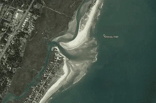
Midway Inlet
Midway Inlet should be considered unnavigable except for vessels drawing less than 3 feet, dead calm weather and Strong local knowledge.
NOTE: There is no access to the Atlantic Intracoastal Waterway.
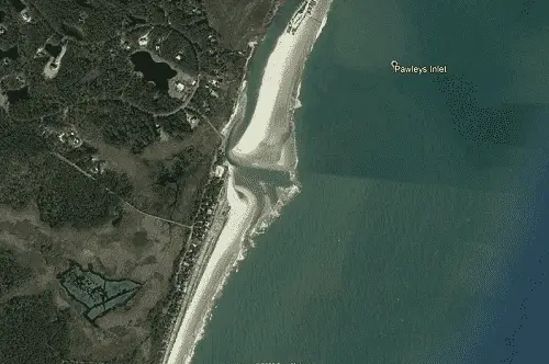
Pawleys Inlet
Pawleys Inlet should be considered unnavigable except for vessels drawing less than 3 feet and dead calm weather. There is no intersection to the Atlantic Intracoastal Waterway via Pawleys Inlet.
NOTE: There is no access to the Atlantic Intracoastal Waterway.
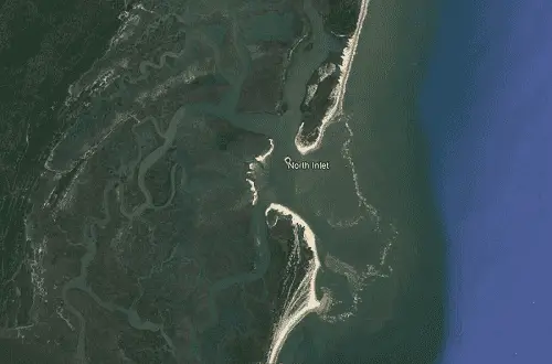
North Inlet
North Inlet, about 13.5 NM SSW of Murrells Inlet and 8.3 NM NNW of Winyah Bay approach buoy.
North Inlet connects with Winyah Bay by way of both Town Creek and Jones Creek providing limited access to the Atlantic Intracoastal Waterway. The approach, entrance, and back creeks are unmarked with a controlling depth over the bar of 3.3 feet in 2010.
Strangers should not use this inlet. Navigation is restricted to shallow-draft craft. In 1983, Jones Creek, the southerly of the two, was found to bare in places, and numerous oyster bars were reported.
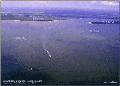
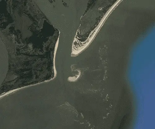
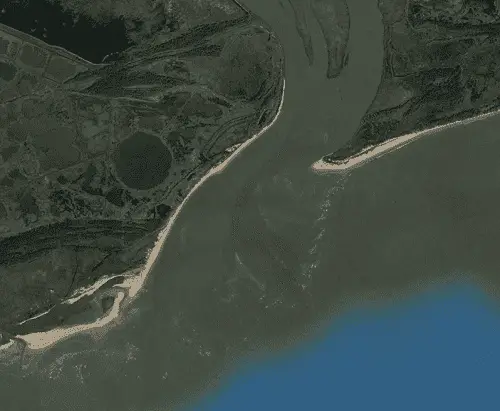
Winyah Bay Entrance
Winyah Bay Entrance is found 30.4 NM SW of Little River inlet and 42.9 NM NNE of Charleston Harbor Approach Buoy. It is located between North Island and South Island providing access to the AICW and Georgetown, SC.
The approach is marked by a lighted buoy (RW "WB" Mo(A)) 3.8 NM east of the entrance at 33°11’37" N., 79°05’11" 'W.
Prominent on the approach is Georgetown Light (Fl (2) 15s 85ft 15M) shown from a white cylindrical tower on the north side of the entrance and Four 400-foot stacks, at a generating plant west of Winyah Bay and about 4 miles southwestward of Georgetown, with prominent strobe lights at the tops.
The approach is deep, with a project depth of 27 feet, and well-marked by lighted buoys and a lighted range. When approaching from the south, mariners should stay outside Cape Romain Shoal Buoy 6CR and Hector Wreck Lighted Buoy WR4, before shaping up for their approach, taking care to avoid the wreck, marked by a lighted buoy WR2, about 9 miles east-northeastward of Hector Wreck Lighted Buoy WR4.
Entrance
The entrance is protected by stone jetties reported to be in ruins the northern jetty is marked just off it’s seaward end with an unlighted buoy (R N "2N"). The southern jetty is unmarked and submerged at the seaward end.
The entrance is deep, project depth of 27 feet to Georgetown and well-marked by lighted buoys and ranges. South Island Bend channel is subject to shoaling and the buoys marking it are often shifted to mark the best water.
The Atlantic Intracoastal Waterway can be intersected 8.5 NM above the entrance at (MM "410.5") near lighted beacon (Fl R 4s 12ft 5M "2").
Cautions
The entrance is not safe for small craft except in favorable weather. East Bank, covered 6 feet and marked by a buoy, about 2 miles south of the end of the south jetty; Hector Wreck, cleared to a depth of 9 feet and marked by a lighted bell buoy, about 12 miles southward of the approach buoy. The mistaking of Winyah Bay Range "B" Lights for the Entrance Channel Range Lights on the approach. Mariners are advised to familiarize themselves with the characteristics of these ranges before making the approach.
Heavy tide rips prevail near the ends of the jetties, and heavy seas run in moderate weather. The south jetty is visible only at low water. The southwest tip of North Island just inside the jetties is building out to the south and is encroaching on the easterly edge of the channel; caution is advised.
Tides & Currents
Mean tidal range at the entrance is about 3.9 feet. In the channels tidal currents average about 2 knots. Outside the jetties, with fresh to strong northeast winds, a strong southerly current is reported to set across the entrance channel and with southerly and southwesterly winds a northerly set is experienced. Tidal ebb currents have been reported in the area from 6 to 7 knots, most notable in Range C and South Island Bend. During freshets in the rivers, also with westerly winds, the velocity of the ebb current between the jetties is reported to be very strong at times and the channel buoys between the jetties are nearly towed under.
North Santee River Entrance
North Santee River and South Santee River Entrances, are both obstructed by shifting bars with little depth. They are considered to be unnavigable.
Vessels bound for the North Santee River are advised to enter by way of Winyah Bay and the Intracoastal Waterway.
South Santee River Entrance
Not Navigable (see North Santee River Entrance).
Vessels bound for the South Santee River are advised to enter by way of Winyah Bay and the Intracoastal Waterway.
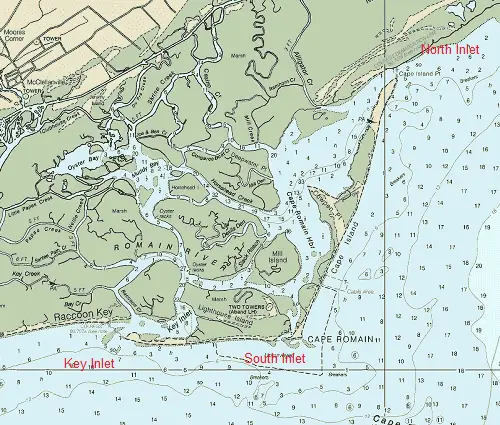
Cape Romain
North Inlet
Cape Romain North Inlet, with approach depths of 2 to 5 feet and 1 foot in the entrance should be considered unnavigable for most vessels. In 1983, the reported controlling depth was 3 feet.
South Inlet
Located between Cape Romain and Lighthouse Island. The approach, leading from the south, is through a large area of un-surveyed depths the entrance has least depths of less than 1 foot. In 1983, Cape Romain Harbor was reported closed.
Key Inlet
Located 2.8 NM west of Cape Romain Harbor South Inlet has least depths of 1 foot in the entrance and is considered Not Navigable.
Five Fathom Creek Inlet
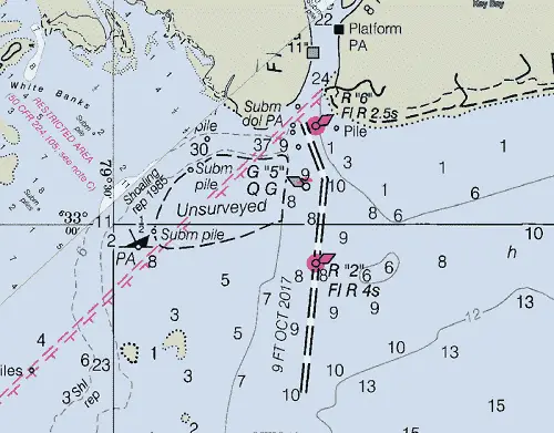
Located 6.0 NM WSW of Cape Romain and is entered westward of Sandy Point at the western end of Raccoon Key. Five Fathom Creek Inlet affords access to the AICW and McClellanville, SC.
The approach is through a dredged channel with 9 feet reported in 2017 and is marked by lighted and unlighted buoys.
The Atlantic Intracoastal Waterway is intersected 4.5 NM above the entrance at (MM "430.1") near beacon (G "25").
Approach
The approach channel is marked with both lighted and unlighted buoys. It is reported to have a controlling depth of 9 feet in 2017.
Entrance
In 2014, the entrance to Five Fathom Creek had a reported controlling depth of 4 feet. Inside the entrance, the channel through Five Fathom Creek deepens with depths to 38 feet. However, within 0.75 NM of the junction with the AICW the depths become shallow; extreme caution is advised.
Cautions
Caution and local knowledge is advised if using this inlet.
Submerged dolphins are located just to the west of the approach channel at the entrance.
Tides & Currents
Mean tidal range at the entrance is about 4.7 feet.
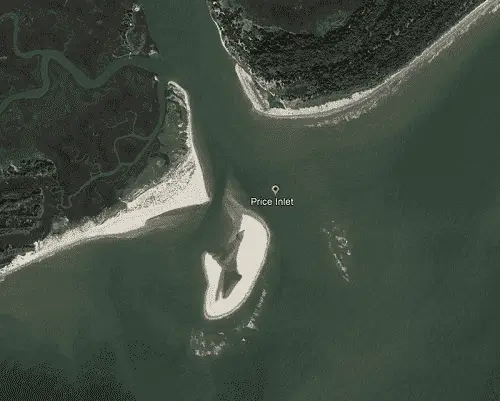
Price Inlet
Located 15.6 NM Northward of the Charleston, SC Approach Buoy and 34 . 3 NM southwestward of Winyah Bay Approach Buoy.
The Atlantic Intracoastal Waterway is intersected 2.2 NM above the entrance at (MM "448.2") near beacon (Fl R 4s 16ft 3M "86").
Approach
The approach and entrance is unmarked, but once inside the entrance, depths of 8 to 44 feet are found mid-channel
Entrance
The entrance and upper reaches of Price Creek are unmarked. The controlling depth in Price Creek from the inner edge of the bar to the Intracoastal Waterway was reported to be 5 feet in 1983. An overhead power cable with a clearance of 85 feet crosses Price Creek about 0.5 NM above the mouth.
Cautions
In average weather conditions, there are heavy breakers on the shoal on the eastern side of the channel and small breakers on the west side.
Tides & Currents
Tides and Currents - Mean tidal range is 4.9 feet in the entrance.
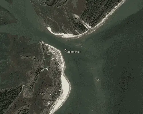
Capers Inlet
Capers Inlet, located between Capers Island to the north and Dewees Island to the south, approximately 14.6 NM NNW of the Charleston Approach Buoy, had a reported depth of about 1.5 feet over the bar, and breakers extended across the entire entrance.
The Atlantic Intracoastal Waterway is intersected 1.3 NM above the entrance at (MM "451.6") near beacon (Fl R 4s 12ft 5M "96").
Approach
Because of the shoal that extends eastward on the south side of the inlet and breaks the southwesterly seas, the channel can be entered when the wind is southwest. A shoal bare at about half tide extends southward along the eastern side of the inlet.
Entrance
In June 1983, the reported controlling depth was 8 feet in Capers Creek from the inner edge of the bar to the Intracoastal Waterway. The channel is narrow and unmarked with numerous stumps and snags outside the high waterline. An overhead power cable over Capers Inlet has a clearance of 86 feet.
Tides & Currents
Mean tidal range is 4.9 feet in the entrance.
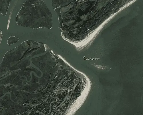
Dewees Inlet
Dewees Inlet, 6.5 NM northeast of Charleston Harbor Entrance lying between Dewees Island and Isle of Palms, had a charted depth of about 1 foot over the bar in 2015 with breakers extending across the entrance. The inside channel is narrow, unmarked, and seldom used.
The Atlantic Intracoastal Waterway is intersected 1.3 NM above the entrance at (MM "454.9") near beacon (G "109").
Approach
The approach to Dewees Inlet is unmarked and shallow. There is very little water over the bar, with depths of about 1 foot extending out almost 1.5 NM from the entrance and breakers extending across the entrance.
Entrance
Once over the bar and in the entrance water depths of 22 to 40+ feet can be found to the intersection with the AICW.
Cautions
Two wrecks, about 0.35 mile apart, are off the eastern shore of the Isle of Palms The wrecks are believed to be the remains of Confederate ships that were apparently sunk by Union forces as they sought to slip into blockaded Charleston Harbor; they are unmarked and are covered 6 feet and 4 feet, respectively. An obstruction, covered 9 feet and unmarked, is about 2.0 NM off the beach at Isle of Palms. Caution is advised in this area.
Tides & Currents
Mean tidal range is 4.9 feet in the entrance.
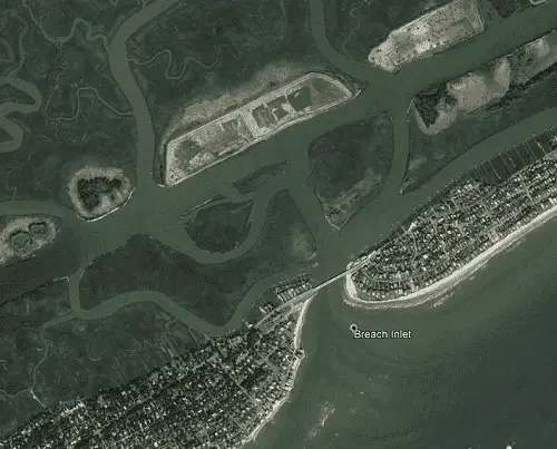
Breach Inlet
Breach Inlet is between Isle of Palms and Sullivans Island, 14.3 NM northwestward of the Charleston Approach Buoy.
The Atlantic Intracoastal Waterway is intersected 0.9 NM above the entrance at (MM "460.0") near beacon (G "117A").
Approach
The approach to Breach Inlet is unmarked and shallow. There is very little water over the bar, with depths of less than 3 feet extending out almost 1 NM from the entrance and breakers extending entirely across the entrance under almost all weather conditions.
Entrance
The entrance and channel are unmarked, but deepens once inside until near the junction with the AICW where depth of less than 4 feet may be encountered.
Cautions
A highway bridge over the inlet has a fixed span with a vertical clearance of 5 feet.
Tides & Currents
Mean tidal range is 4.9 feet in the entrance. Currents are extremely strong in this inlet.
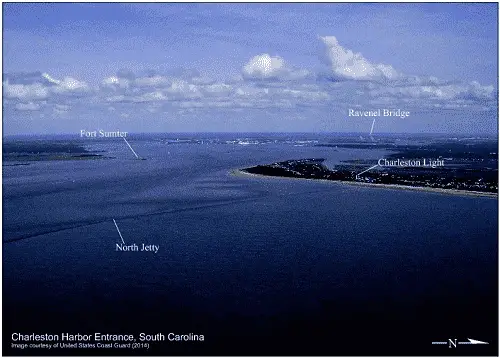
Charleston Harbor
Charleston Harbor, 43 NM SSW of Winyah Bay Entrance Buoy and 59.6 NM northeast of Port Royal Sound Approach Buoy. The AICW, as well as the Cooper, Wando, and Ashley Rivers, and the city of Charleston can be accessed. The approach and entrance is easy day or night in clear weather. It is also one of the best Harbors of Refuge on the southeast coast of the U.S.
The Atlantic Intracoastal Waterway can be intersected 4.0 NM above the entrance at (MM "465.0") near buoy (R "2" Fl R 2.5s).
Approach
The approach is marked by a buoy (RW "C" Mo(A) RACON (–·–) AIS equipped) located 12.8 NM southeast of the entrance at 32°37’05" N / 079°35’30" W. The approach channel is deep 45+ feet and well-marked with lighted buoys and a lighted range.
Prominent on the approach is Charleston Light (Fl (2) 30s 163ft 26M) shown from a triangular tower, upper half black, lower half white, on Sullivans Island on the north side of the entrance. The 155-foot conical tower of the abandoned old Charleston Lighthouse on Morris Island south of the entrance. Fort Sumter is on the southwest side of the channel just inside the entrance. ) The twin diamond-shaped towers of the Ravenel fixed bridge are reported to be 575 feet tall and clearly visible to the mariner before entering.
Entrance
The entrance to Charleston Harbor is between converging jetties extending nearly 3.0 NM seaward. The north jetty is almost completely submerged at MHW. There are no lights on the jetties, and smaller craft approaching from the north close to shore at MHW should exercise extreme caution not to confuse the south jetty for the north jetty. It is recommended all vessels align well seaward of Lighted Buoy 18 before final approach to the jetty entrance.
Cautions
The areas generally to the east and southeast of Charleston Harbor are used extensively by the U.S. Navy and other military services to conduct various types of surface, subsurface and aircraft training exercises. Not infrequently, portions of Charleston Harbor are affected by poor visibility. This occurs during line squalls of heavy rain accompanying the passage of frontal systems, rare snow squalls and fog. Fog over only a part of the harbor, however, is a reasonably frequent occurrence. Intracoastal Waterway; the eastern conjunction of this waterway with Rebellion Reach. Westbound vessels proceeding on the AICW into Charleston Harbor are not readily visible to vessels inbound from sea until they are clear of the northernmost part of Sullivans Island.
The danger area of a former World War II minefield is off the entrance to Charleston Harbor. The area is open to unrestricted surface navigation but all vessels are cautioned not to anchor, dredge, trawl, lay cables, bottom or conduct any similar type of operation because of residual danger from mines on the bottom. A dangerous submerged obstruction with a least depth of 9 feet is southeast of the outer end of the south jetty located at 32°42’43" N / 79°48’37" W. Caution is advised. Rattlesnake Shoal, 3 miles offshore and the same distance east-northeastward of the north jetty has a least depth of 10 feet. A buoy is east of the outer end of the shoal. There are also several unmarked charted dangers inside the sea buoy; caution is advised in this area.
Tides & Currents
Tidal ranges average 5.2 feet in most harbor locations. Off the entrance to Charleston Harbor the tidal currents are rotary with velocities of about 1 knot. Near the entrance to the jetties the current sets fair with the channel at strengths of flood and ebb and can be expected to set across the channel with a velocity of about 0.2 knot about 3 hours after strength of flood and ebb, setting northeastward and southwestward, respectively. It is reported that tide rips, hazardous to small craft, may be encountered off the jetties when wind and current are opposed. The current at the strengths of flood and ebb are about 1.2 knots and 2.8 knots, respectively.
Lighthouse Inlet
Lighthouse Inlet is located between Morris Island and Folly Island, 3.9 NM southwest of the Charleston Entrance.
There is no channel across the bar and the approach is unmarked, covered 1 to 3 feet, and reported bare in spots.
Prominent on the approach is an abandoned light house on the north side of the entrance.
Entrance
The entrance is unmarked with depths of 3 to 10 feet. The inside channel has depths of 1 to 30+ feet.
Cautions
This inlet should not be attempted without strong local knowledge.
Tides & Currents
Tidal ranges average 5.5 feet.
Stono Inlet
Stono Inlet, 10 miles southwestward of Charleston Harbor entrance between Folly Island and Kiawah Island. The inlet is subject to continual change and should not be attempted without local knowledge.
The Atlantic Intracoastal Waterway can be intersected 10.8 NM above the entrance at (MM "472.6") near beacon (R "18").
Approach
The outer approach is unmarked while the approach channel is over a shifting bar covered 2 to 4 feet. Local knowledge is advised.
The approach channel buoys are not charted, because they are frequently shifted in position to mark the best water.
Entrance
The entrance and channel to the AICW is deep with depths of 11 to 30+ feet.
Cautions
A shifting bar blocks the approach.
Tides & Currents
Tidal range averages 5.3 feet.
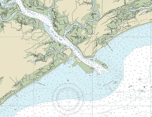
North Edisto River Inlet
North Edisto River is located between Seabrook Island to the northeast and Edisto Island on the southwest, about 10 NM southwestward of Stono Inlet and 13.8 NM miles northeast of St. Helena Sound Entrance.
The Atlantic Intracoastal Waterway can be intersected 6.6 NM above the entrance at (MM "496.7") near lighted beacon (Fl R 4s 12ft 5M "108").
Approach
The approach is marked by a lighted buoy (R "2NE" Fl R 4s) located 4.0 NM southeast of the entrance at 32°31’21" N / 080°06’51" W.
The approach channel has a least charted depth of 10 feet (2020) and is marked with lighted and unlighted buoys.
Prominent on the approach is a water tank on Seabrook Island about 1.7 miles northeastward of the entrance.
Entrance
The entrance is deep with depths of 23 to 60+ feet. The channel is marked by a lighted range and by buoys that are moved, when practicable, to indicate the best water. The entrance is well defined by breakers.
Cautions
Shoals extend offshore from the entrance as much as 3 NM and form a shifting bar.
Inside the bar, in the channel between the breakers, the ebb current is to be guarded against, especially when it sets across the north breakers.
Flats, which bare at low water and are continually changing in character, are on both sides of the approach and entrance; caution is advised.
Tides & Currents
Tidal range averages 5.8 feet.
Currents on the bar are generally across the channel. The flood current sets about westward and the ebb eastward; both have considerable velocity.
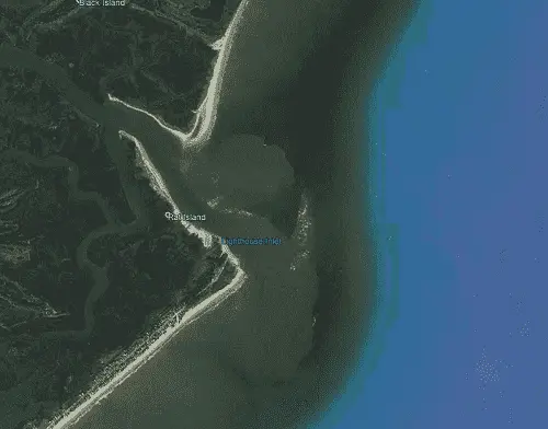
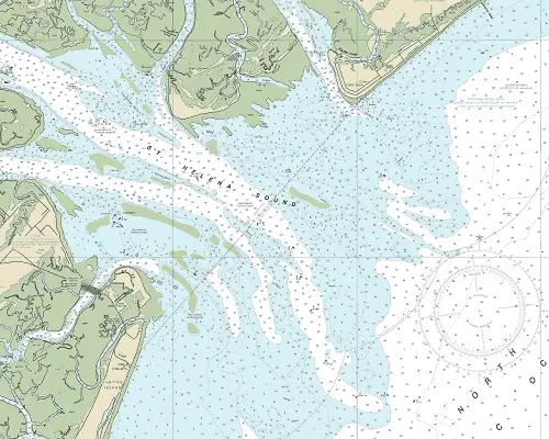
St. Helena Sound
St. Helena Sound is located between Edisto Island to the north and Hunting Island to the south, about 13.8 NM southwestward of the North Edisto River Approach and 21.7 NM miles northeast of Port Royal Sound Approach Buoy.
The Atlantic Intracoastal Waterway can be intersected 8.0 NM above the entrance at (MM "518.6") near lighted beacon (Fl R 2.5s 16ft 3M "186").
Approach
The approach is marked by an unlighted buoy (G C "1") located 5.3 NM southeast of the entrance at 32°21’39" N / 080°18’28" W.
The main approach channel is well-marked with unlighted buoys and has minimum charted depth of 15 feet in 2020. Breakers and shoals line both sides of the approach; caution is advised.
Prominent on the approach is the 132-foot Hunting Island Light (F Fl 30s 132ft Priv)) and the elevated tank on the northern part of Hunting Island make good landmarks.
Entrance
The entrance channel is deep with depths of 19 to 40 feet. It is reasonably well marked with charted unlighted buoys and lighted beacons. Shoals exist on the southwestern side of the entrance covered 2 to 7 feet and the area is subject to continual change.
Cautions
Shoals extend offshore from the entrance as much as 3 NM and form a shifting bar. A partially submerged wreck was 4.8 NM NNE of St. Helena Sound Approach buoy (G C "1") at 32°26.0’N., 80°16.0’W.
Tides & Currents
The mean range of tide on the bar and in the entrance to the sound is 5.8 feet.
Fripp Inlet
Fripp Inlet is 7.5 NM WSW of the approach to St. Helena Sound lying between Hunting Island to the northeast and Fripp Island to the southwest.
There is no access to the Atlantic Intracoastal Waterway.
Approach
The approach is well defined by breakers and flats that show at low water and are reportedly marked by private buoys. This area is subject to change and caution is advbised.
Prominent on the approach are (2) spherical water tanks on Fripp Island.
Entrance
The entrance is also well defined by breakers and flats that show at low water. The entrance is subject to continual change; entrance should not be attempted without local knowledge. A highway bridge across the inlet has a fixed span with a vertical clearance of 15 feet.
Cautions
Strong local knowledge is advised.
Tides & Currents
Tides and Currents - The mean range of tide just inside the entrance is 6.1 feet.
Skull Inlet
Skull Inlet, 3 miles southwest of Fripp Inlet, is a narrow passage with breakers at the entrance and very little water over the bar.
The approach and entrance are unmarked with 2 feet or less of water on the approach.
There is no access to the Atlantic Intracoastal Waterway.
Pritchards Inlet
Pritchards Inlet is 5 NM northeast of Port Royal Sound, is a narrow passage from the ocean to Moon Creek that connects with the upper part of Trenchards Inlet; there is very little water over the bar.
The approach and entrance is unmarked and the entrance is reported to shoal to bare at low water.
There is no access to the Atlantic Intracoastal Waterway.
A partially sunken wreck lies 0.3 NM southeast of the entrance.
Trenchards Inlet
Trenchards Inlet, just northeast of Port Royal Sound, has a bar that extends about 2 miles from shore.
The approach and entrance is narrow and unmarked. The channel over the bar had a reported controlling depth of 3 feet in 1983. Local knowledge is advised.
There is no access to the Atlantic Intracoastal Waterway.
Port Royal Sound
Port Royal Sound Entrance is located between Bay Point Island on the northeast and Hilton Head Island on the southwest. It is 59.6 NM southwest of the Charleston Approach Buoy and 10 NM northeast of Tybee Roads Approach. It is one of the largest deep water harbors on the Atlantic Coast between Cape Henry and Key West.
The Atlantic Intracoastal Waterway can be intersected 3.5 NM above the entrance at (MM "548.5") near lighted beacon (Fl R 4s 16ft 5M "246").
Approach
The approach is marked by lighted buoy (RW "P" Mo(A)) located 8.8 NM SSE of the entrance at 32°05’08" N / 080°35’02" W and is between shoals that extend up to 10 NM offshore.
The approach channel project provides for a dredged channel 27 feet deep across the bar and through the sound. It is well-marked with lighted buoys.
Prominent on the approach are three water tanks on Hilton Head Island and the breaking shoals.
Entrance
The entrance is deep, wide, and well marked with depths of 30 to 60+ feet in the main channel. In addition to the main entrance channel, several unmarked channels, all requiring local knowledge lead through the breakers.
Cautions
The breaking shoals extending almost 10 miles off Bay Point, eastward of the entrance channel, and for about 8 miles off Hilton Head Island, are the principal dangers. In thick weather, vessels should not approach the entrance too closely especially on the flood, when the current sets directly onto the shoals. Danger zones of rifle and pistol ranges are in Broad River, Archers Creek and Ribbon Creek.
Tides & Currents
The mean range of tide is 6.1 Feet at the entrance. The tidal currents on the bar have a velocity of 1.5 knots, off Hilton Head 1.8 knots and at Beaufort River entrance 1.4 knots. The current generally sets fair with the channel, except at the turn from the entrance channel into Bay Point Reach, where a strong current sets diagonally across the channel. Vessels should exercise caution lest they be set onto St. Michaels Breakers, eastward of the bar channel.