Perdido Pass
Found 13.8 NM west of Pensacola Approach Channel and 27.7 NM ENE of the entrance to Mobile Bay. Perdido Pass enters between Florida Point on the east and Alabama Point on the west. It allows access to Orange Beach, Ono Island, Caswell, AL, and the GIWW.
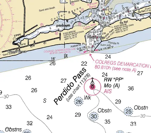
NOAA Chart #11382 - Pensacola Bay and Approaches is suggested for the approach to Perdido Pass while NOAA Chart #11378 - Santa Rosa Sound to Dauphin Island is suggested for the entrance.
The Gulf Intracoastal Waterway (GIWW) can be intersected 3.9 NM above the entrance at MM "166.9 EHL" in the vicinity of lighted beacon (Fl G 4s 17ft 4M "57").
Approach
The approach is marked by buoy (RW "PP" Mo (A)) equipped with an AIS Transponder lying 0.7 NM off of the outer ends of the jetties.
Good water lies between the Approach buoy and the outer ends of the jetties with charted depths of 22 to 30 feet.
Entrance
The entrance is protected by jetties on the east and west sides. Over half of the east jetty is submerged at low tide, caution is advised. The pass itself is well marked by lighted beacons just inside the jetties and lighted and unlighted buoys and beacons for the remainder of the pass and adjacent channels. A fixed bridge crosses the head of the pass with (2) spans available. The Cotton Bayou Channel has a vertical clearance of 41 feet and the Perdido Channel offers a clearance of 54 feet. The charted depths shown in the entrance were 12 to 18 feet with deeper water reported mid-channel.
Cautions
A fixed bridge with clearances of 41 or 54 feet (channel dependent) spans the head of the pass.
Tides & Currents
The mean tidal range is 0.8 feet at the pass.
Little Lagoon Inlet
Lying about 9.5 NM west of Perdido Pass Approach Buoy and 15 NM east of Mobile Point, this is a small inlet protected by jetties.
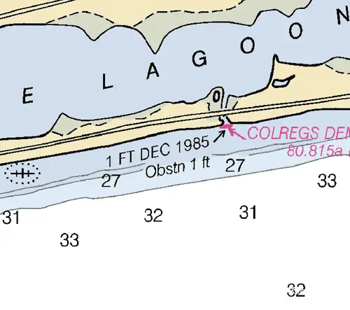
It connects Little Lagoon with the Gulf of Mexico. It was reported that the east jetty has partially collapsed and about 40 feet of the seaward end covers at low water.
In 1985, the reported controlling depth through the opening was 1.5 feet. A footbridge, a fixed highway bridge, and a pipeline with a least clearance of 7.5 feet cross the entrance.
It is reported that the inlet is no longer navigable. There is no access to the Gulf Intracoastal Waterway through Little Lagoon Inlet.
Mobile Bay Entrance
Found 40 NM west of Pensacola, FL and 90 NM northeast of South Pass, Mississippi River, is the Mobile Bay Entrance lying between Dauphine Island to the west and Mobile Point to the east. It provides easy access to Dauphine Island, the Gulf Intracoastal Waterway, Mobile, AL, and to the Alabama and Tombigbee Rivers.
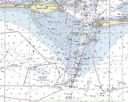
NOAA Chart #11376 - Mobile Bay is suggested for the approach to Mobile Bay while NOAA Chart #11377 - Mobile Bay Approaches and Lower Half is suggested for the entrance.
The Gulf Intracoastal Waterway (GIWW) can be intersected 2.7 NM above the entrance at MM "128.6 EHL" in the vicinity of lighted buoys (G "25" Fl G 4s) and (R "26" Fl (2) R 5s).
Approach
The approach is marked by buoy (RW "M" Mo (A) at 30°07’31"N / 88°04’07"W); lying 7.2 NM SSW of the entrance.
The approach channel leads through an extensive bar covered 4 to 28 feet. The channel is well-marked with lighted buoys and has a controlling depth of 47+ feet in June 2018.
Prominent on the approach is Mobile Point Light (Fl 10s 125ft 14M) at 30°13’41" N / 88°01’27" W, shown from a skeleton tower on Mobile Point.
The landmark 131-foot black conical tower (30°11.3’ N / 88°03.0’ W), which was the base for the former Sand Island Light lying 2.5 NM SSW of Mobile Point and Fort Morgan’s pentagon shaped brick walls on Mobile Point.
Vessels should approach Mobile Bay through the prescribed Safety Fairways.
Entrance
The entrance to Mobile Bay is 2.8 NM wide between Mobile Point on the east and Pelican Point on the west. Pelican Bay located on the west side of the entrance and having depths of 7 to 12 feet is passable with local knowledge, but most vessels will prefer to follow the dredged channel rather than chance passage between the breakers and shoals.
The entrance channel passes just west of Mobile Point, it is deep with controlling depths of 45+ feet mid-channel. It is well-marked with lighted buoys and a lighted range.Inside the bar, depths in the channel increase to as much as 56 feet.
Cautions
Cautions – The Coast Guard advises vessels exercise caution where the channel intersects the GIWW. Situations resulting in collisions, groundings, and close quarters passing have been reported.
Shoals extend about 4.5 miles S and W of Mobile Bay entrance. Southeast Shoal, covered 3 feet, is on the E side of the Bar Channel, and Sand Island Shoal, covered 1 foot, and West Bank, covered 3 feet, are on the W side.
The wreck of the MAGNOLIA is on the east side of the channel, 0.6 NM SSW of Mobile Point near buoy (R "16" Fl R 4s).
The wreck of the Civil War vessel "Tecumseh" is just north of Mobile Point Light at 30°13’47.5" N / 88°01’37.5" W. The wreck is marked by a buoy. The vessel is reported to be in an unstable condition, and ammunition and powder aboard the wreck could be detonated if the vessel shifts. Mariners are cautioned not to anchor in the area of the buoy and to reduce speed producing as little wake as possible when transiting Mobile Channel between Buoys "15" and "17."
Tides & Currents
The mean tidal range is small, averaging 1.2 feet at Mobile Point. The tidal current near the outer end of the approach channel is rotary. Strong winds have considerable effect in modifying the times and velocities of the current. It has been reported that velocities of 8 to 10 knots have been observed in the Bar Channel and Mobile Bay Channel on the ebb after protracted periods of strong south winds.
Petit Bois Pass
Petit Bois Pass from the Gulf of Mexico between Dauphin Island and Petit Bois Island affording access to the GIWW and Bayou La Batre, AL. It is located 16.7 NM WNW of the Mobile Approach Buoy and is used primarily by fishing vessels with local knowledge drawing about 6 feet or less.
The pass is no longer maintained and subject to frequent changes. Mariners are advised to use local knowledge to safely transit the pass. Passage can generally be made by following the deep green water during calm weather and by avoiding the breakers during rough weather. The chart and knowledge of local conditions are the best guides.
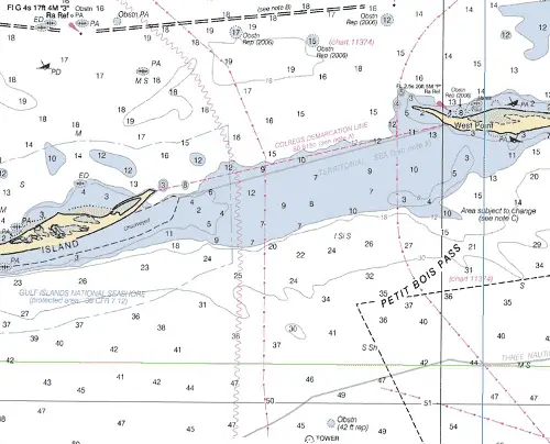
The Gulf Intracoastal Waterway can be intersected 1.9 NM above the pass at approximately MM "112.3 EHL" near and west of lighted beacon (Q G 17ft 3M "5").
