Whether you are sailing coastwise along the south side of Long Island, New York’s Coast or making use of the non-contiguous inland waterway, a number of Entrances, Inlets, or Passes exist between the offshore waters of the Atlantic Ocean and Long Island’s inland waters.
At last count, in January 2021 there were (8) entrances, inlets, or passes found along Long Island's south shore coastline including the entrance to New York Harbor. Beginning in the east at Montauk Point west to New York Harbor, (7) of these inlets provide access to sheltered waters.
While a couple of these entrances and inlets are only suitable for very shallow draft vessels with strong local knowledge and some are closed to navigation; a few can be considered navigable for most vessels. We have listed them below along with useful information on each to aid you in deciding if you wish to use a particular inlet.
Keep in mind when entering any small inlet or entrance on the east coast of the U.S., the best time to enter is on a rising tide with a smooth sea; passage may be hazardous during easterly gales and heavy seas.
Shinicock Inlet
Shinicock Inlet is located 72.7 NM east of Sandy Hook Light, NJ and 31.9 NM southwest of Montauk Point, NY. The Shinicock Inlet provides access to Shinicock Bay, Hampton Bays, South Hampton, and the Great Peconic Bay via the Shinicock Canal. It is the easternmost entrance from the Atlantic Ocean to Shinnecock Bay and the inland water route along Long Island’s southern shore.
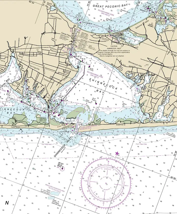
NOAA Chart #12353 - Shinicock Light to Fire Island Light is suggested for the approach to Shinicock Inlet while NOAA Chart #12352 - Shinicock Inlet to East Rockaway Inlet is suggested for the entrance.
Approach
The safest offshore approach to Shinicock Inlet is from the northeast through southwest. These approaches are deep with depths greater than 45 feet and free of off-lying dangers.
Prominent on the approach to Shinicock Inlet at night is Shinnecock Light (Fl(2) 15s 75ft 11M) at (40°50’31" N / 072°28’42" W). It is shown from a red skeleton tower on the west side of the inlet.
The inner approach is marked by lighted buoy (RW "SH" Mo (A) WHIS AIS) located 1.4 NM south of the entrance at (40°49’00" N / 072°28’35" W). The approach channel is marked by uncharted aids to navigation to mark the best water.
Entrance
Stone jetties protect the entrance and are marked by lighted beacons (Fl R 2.5s 36 ft 4M) on the east jetty and (Fl G 2.5s 36ft 4M) on the west jestty. The jetties extend about 120 yards beyond the lights marking them. The natural entrance channel is deep with depths of 23 to 37 feet.
Once inside the entrance depths of 13 to 25 feet are found in the marked channel.
Cautions:
The inlet should not be attempted without local knowledge because of the frequent changes in channel depths.
Tidal currents through the inlet can be dangerous; caution is advised.
Tides & Currents:
The tidal range at the entrance is ≈3.1 feet. Current velocities average 2.5 knots on the Flood and 2.3 knots on the ebb.
Moriches Inlet
Moriches Inlet, 13.5 NM WSW of Shinicock Inlet, is a shallow entrance from seaward to Moriches Bay. Weather continuously changes the jettied entrance, which is subject to extreme shoaling. Both east and west jetties are marked by a light, and the approach to the inlet is marked by a lighted whistle buoy.
Due to rapidly changing shoaling conditions and existing dangers in Moriches Inlet, it is considered unsafe for mariners to navigate this inlet at any time. Buoys are not maintained in this inlet.
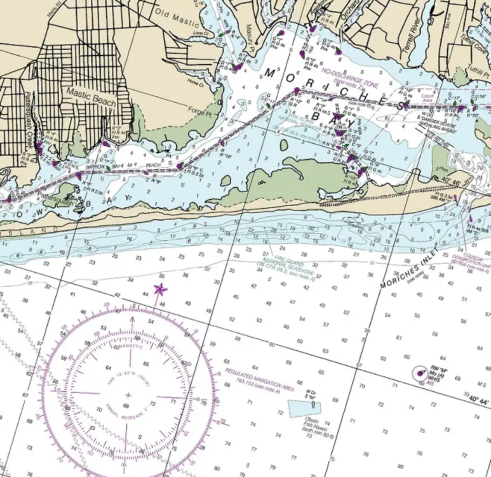
NOAA Chart #12353 - Shinicock Light to Fire Island Light is suggested for the approach to Shinicock Inlet while NOAA Chart #12352 - Shinicock Inlet to East Rockaway Inlet is suggested for the entrance.
Approach
The approach buoy (RW "M" Mo (A) WHIS AIS) lies 1.7 NM south of the entrance at (40°44’08" N / 072°45’12" W). There is no marked channel for the approach
Entrance
The entrance is obstructed by an off lying bar covered 4 to 24 feet. There is no marked channel in the entrance. The entrance jetties are marked by lighted beacons. The eastern jetty shows (Fl R 4s 30ft 4M "2" while the west jetty shows (Fl G 2.5s 28ft 4M "1")
Cautions
Due to rapidly changing shoaling conditions and existing dangers in Moriches Inlet, it is considered unsafe for mariners to navigate this inlet at any time.
Aids to navigation are not maintained in this inlet.
An unlighted fish haven buoy (W Or S "M") is about 2.5 miles south-southwestward of Moriches Inlet East Breakwater Light.
Tides & Currents
Tidal range at the entrance is ≈2.2 feet. Current velocities are reported to be strong on both the flood and the ebb.
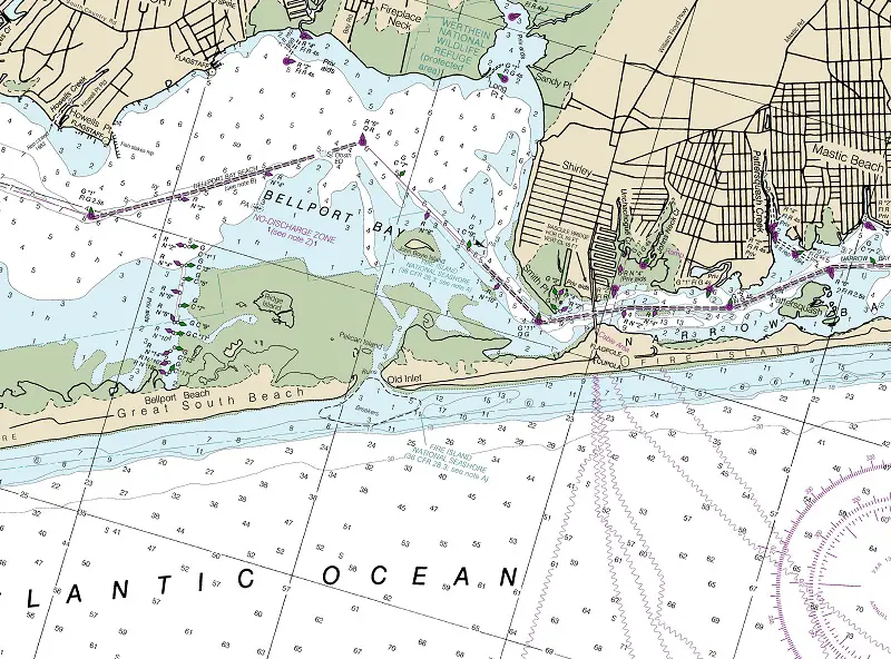
Old Inlet
Old Inlet is effectively closed to navigation due to shoaling. The inlet is obstructed by breakers and a bar covered 1 to 3 feet.
NOAA Chart #12353 - Shinicock Light to Fire Island Light is suggested for the approach to Shinicock Inlet while NOAA Chart #12352 - Shinicock Inlet to East Rockaway Inlet is suggested for the entrance.
Approach
The approach to Manasquan Inlet is marked by Lighted Buoy (R "2M" Fl R 4s) located 1.0 NM southeast of the entrance at (40°05’32" N / 074°00’48" W). The approach from the eastern quadrants is deep with depths of 15 to 50 feet to the entrance jetties and shows no charted hazards.
Fire Island Inlet
Fire Island Inlet, found 28 miles westward of Moriches Inlet, is the only direct entrance from the Atlantic to Great South Bay. The inlet is subject to extreme shoaling. Mariners should seek local knowledge of the latest conditions before entering. Navigation of the inlet is difficult. Fire Island Inlet remains open throughout the year, but ice does become a problem in the inland channels through Great South Bay.
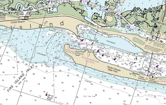
NOAA Chart #12326 - Approaches to New York is suggested for the approach to Fire Island Inlet while NOAA Chart #12352 - Shinicock Inlet to East Rockaway Inlet is suggested for the entrance.
Approach
The safest offshore approach to Fire Island Inlet is from the east through WSW. These approaches are deep with depths of 50 feet or more and free of off-lying dangers.
A traffic separation scheme (heavy traffic entering and departing New York Harbor) lies 7 NM south of the approach buoy.
Prominent on the approach at night is Fire Island Light (Fl 7.3s 167ft 24M) located 4.4 NM east of the entrance at (40°37’57" N / 073°13’07" W).
The approach buoy (RW "FI" Mo (A) WHIS) lies 1.5 NM south of Democrat Point at (40°36’08" N / 073°19’04" W).
An unlighted buoy(Y C "A") lies 1.9 NM southwest of the approach buoy.
The approach channel is marked with uncharted buoys and a bar covered 2 to 11 feet partially obstructs the entrance.
Entrance
The entrance is deep with depths of 28 to 33 feet. Once inside the entrance the channel is well-marked with charted lighted and unlighted buoys.
Cautions
The inlet is subject to extreme shoaling. Buoys are not charted because they are moved periodically to mark the best water.
Large areas of unsurveyed waters exist on the approach and just inside the entrance. These areas should be avoided.
Mariners are warned of extreme tidal turbulence especially during times of tide change.
Navigation of the inlet is difficult even with relatively calm seas, and for small craft it can be extremely dangerous. During heavy weather, the entrance usually is obstructed by breakers.
Tides & Currents
Tidal range at the entrance is ≈2.6 feet. Current velocities average 2.4 knots on the flood and on the ebb.
Jones Inlet
Jones Inlet, is about 12 NM westward from Fire Island Inlet and is the principal entrance from the Atlantic Ocean to the inside passages and towns in Hempstead Bay. The inlet, which is used mostly by pleasure craft, should not be attempted without local knowledge. Buoys and soundings are not charted because the channel and depths are constantly changing.
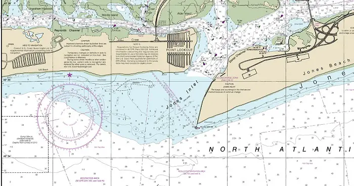
NOAA Chart #12326 - Approaches to New York is suggested for the approach to Jones Inlet while NOAA Chart #12352 - Shinicock Inlet to East Rockaway Inlet is suggested for the entrance.
Approach
The safest offshore approach to Jones Inlet is from the southeast through southwest. These approaches are deep with depths of 31 feet or more and free of off-lying dangers.
A traffic separation scheme (heavy traffic entering and departing New York Harbor) lies 4.8 NM south of the approach buoy.
Prominent on the approach is a lighted water tower (202 feet) 3.1 NM westward of the entrance.
The Jones Inlet approach buoy (RW "JI" Mo (A) WHIS) is located 1.3 NM SSW of the entrance at (40°33’37" N / 073°35’13" W).
Entrance
The entrance is a little less than 1.0 NM wide with a large portion being shoal. Careful attention needs to be given to the marked channel.
A light is at the outer end of the jetty on the east side of the entrance shows (Fl 2.5s 33ft 4M.
Once inside the entrance, depths increase to 17 to 36 feet. It is well-marked by lighted and unlighted buoys.
Cautions
Jones Inlet should not be attempted without local knowledge. Navigable channel and depths are subject to frequent change.
A bar covered 3 to 17 feet obstructs the entrance.
Tides & Currents
Tidal Range averages ≈3.2 feet in the inlet and the tidal current in the inlet has a velocity of about 3.1 knots on the flood and 2.6 knots on the ebb.
East Rockaway Inlet
East Rockaway Inlet, lies about 8 NM westward of Jones Inlet. It is the westernmost entrance from the Atlantic Ocean to Hempstead Bay and the inland water route along the south shore of Long Island. The inlet is subject to frequent changes but is reported to be usually safer to navigate than Jones or Fire Island Inlets.
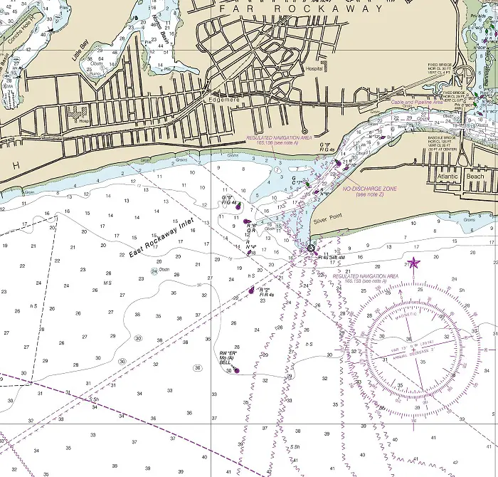
NOAA Chart #12326 - Approaches to New York is suggested for the approach to Jones Inlet while NOAA Chart #12352 - Shinicock Inlet to East Rockaway Inlet is suggested for the entrance.
Approach
The safest offshore approach to East Rockaway Inlet is from the southeast through southwest. These approaches are deep with depths of 35 feet or more and free of off-lying dangers.
The East Rockaway Inlet approach buoy (RW "ER" Mo (A) Bell) is located 0.8 NM SSW of the entrance jetty light at (40°34’17" N / 073°45’49" W).
The approach channel is well-marked with lighted and unlighted buoys with a least depth of 7 feet shown.
Prominent on the approach are (2) large identical apartment buildings about 0.8 NM north-northeastward of the jetty light.
Entrance
The entrance is deep, 11 to 30 feet and also well-marked with lighted and unlighted buoys. A bascule bridge crosses the inner portion of the entrance with a closed clearance of 25 feet (30 feet at the center).
Cautions
Precautionary area 5.5 NM south of the East Rockaway Inlet approach buoy is the terminus of (3) major inbound and outbound traffic lanes to New York Harbor, a pilot boarding area, and the seaward end of the Ambrose Channel into New York. Expect heavy marine traffic in this area.
The navigation aids marking the inlet are periodically moved to mark the best water; local knowledge is advised.
Tides & Currents
Tidal range is 4.4 feet in the inlet and the tidal current has a velocity of about 2.9 knots on the ebb and 2.2 knots on the flood. Caution should be exercised when passing through the inlet at times of maximum current.
Rockaway Inlet
Rockaway Inlet, the entrance to Jamaica Bay, lies 8.6 NM WSW of East Rockaway Inlet and 4.9 NM NNE of Sandy Hook Light.
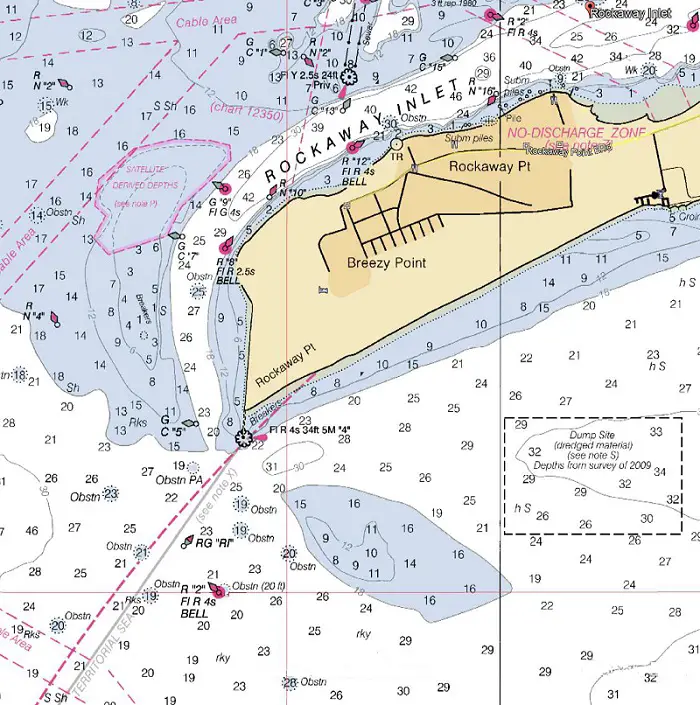
NOAA Chart #12326 - Approaches to New York is suggested for the approach to Rockaway Inlet while NOAA Chart #12350 - Jamaica Bay and Rockaway Inlet is suggested for the entrance.
Approach
The safest offshore approach to Rockaway Inlet is from the southeast through south. These approaches having a minimum charted depth of 15 feet from the south and 20 feet from the southeast and free of off-lying dangers.
The approach buoy (R "2" Fl R 4s BELL) is 0.7 NM SSW of the inlet breakwater light, located at (40°31’45" N / 073°56’35" W).
The approach channel is well-marked with lighted and unlighted buoys, and a lighted beacon (Fl R 4s 34ft 6M "4") at the end of Rockaway Point Breakwater. Water depths on the approach range from 17 to 43 feet.
Numerous obstructions lie from southeast to southwest of the breakwater light; the chart is the best guide.
Entrance
The entrance channel extends westward of the entrance and is marked by lighted and unlighted buoys and a lighted beacon (Fl Y 2.5s 24ft Priv).
Numerous wrecks and obstructions are further inside the inlet; the chart is the best guide.
Depths in the marked entrance channel vary from 29 to 46 feet.
Cautions
In 1980, shoaling to about 3 feet was reported in the inlet about 1.75 miles west of the Gil Hodges Memorial Bridge in about (40°34’21" N / 073°55’30" W).
A shifting sandbar covered 8 to 16 feet is located about 0.6 NM southeast of the breakwater light.
A shoal with depths of less than 1 foot and marked by breakers is west of the approach channel.
Numerous obstructions lie from southeast to southwest of the breakwater light and numerous wrecks are farther inside the inlet; the chart is the best guide.
Tides & Currents
The tidal range averages 5.2 feet and the tidal current in the approach channel near Rockaway Point has a velocity of about 2.2 knots. East of Barren Island the velocity is about 1.5 knots.
New York Harbor Entrance
The principal entrance by water to New York City and the surrounding ports of Bayonne, NJ, Elizabeth, NJ, Jersey City, NJ, Brooklyn, NY, and New York City, NY. The Battery, which is the southern tip of Manhattan, is at the junction of East River; leading to Long Island Sound and the Hudson River; leading to Albany, NY and the New York State Canals.
Ambrose Channel, the principal entrance, extends from the sea to The Narrows. Anchorage Channel, an extension of Ambrose Channel, leads through Upper Bay to The Battery. Hudson River Channel continues northward from The Battery for about
5 miles to West 59th Street, Manhattan.
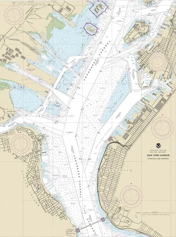
NOAA Chart #12326 - Approaches to New York and NOAA Chart #12402 - New York Lower Bay are suggested for the approach to New York while NOAA Chart #12334 - New York Harbor is suggested for the entrance.
Approach
The safest offshore approach to New York Harbor is by making use of the traffic separation schemes. These approaches are deep with depths of 62 to 200+ feet and free of off-lying dangers.
A mandatory vessel traffic service (for specific vessels) has been established in the navigable waters of Lower New York Harbor.
The approach buoy (RW "A" Mo (A) WHIS RACON (— · )) is located 10.7 NM southeast of Coney Island Light (Fl R 5s 75ft 16M) and 7.7 NM east of Sandy Hook Light. At (40°27’28" N / 073°50’12" W) and marks the seaward end of the approach (Ambrose Channel).
The approach channel leads through New York’s Lower Bay to the entrance at the Verrazano Narrows, it is well marked with lighted buoys, many AIS equipped. The lower portion of Ambrose channel is marked with range lights. The channel is deep with a project depth of 53 feet to the entrance.
Entrance
The entrance is known as "The Narrows," and is crossed by the Verrazano-Narrows fixed bridge with a vertical clearance of 215 feet at the center. The entrance is 0.6 NM wide and deep between the bridge piers with depths ranging between 49 and 85 feet.
Cautions
There are five shoal areas in the entrance to New York Harbor that are subject to change in depths and should be avoided by strangers:
- False Hook covered 8 to 17 feet is off the northeastern side of Sandy Hook.
- Flynns Knoll covered 8 to 17 feet is between Swash Channel, Sandy Hook Channel, and Chapel Hill Channel.
- Romer Shoal covered 5 to 17 feet, between Ambrose and Swash Channels, is marked by Romer Shoal Light.
- East Bank covered 5 to 17 feet is northward and eastward of Ambrose Channel.
- West Bank covered covered 2 to 17 feet is westward of Ambrose Channel between West Bank (Range Front) Light and Fort Wadsworth. Numerous rocks and obstructions lie between West Bank and the western limit of Ambrose Channel.
The chart is the best guide for remaining clear of these areas.
The tip of Sandy Hook is changeable, and the area around it is subject to severe shoaling; caution should be exercised in the area.
Tides & Currents
Tidal range at "The Narrows" averages 4.8 feet and an average of 4.5 feet is found at "The Battery."
The flood current entering the Lower Bay from the sea attains a velocity of about 1.7 knots at the seaward end of Ambrose Channel and at The Narrows. It sets generally parallel to the lower section of Ambrose Channel and tends to continue in that direction where the channel turns towards The Narrows, setting more or less diagonally across the upper section of Ambrose Channel.
The ebb current in Lower Bay is generally stronger than the flood by 10 percent or more averaging 2.3 knots. At its strength it sets from The Narrows approximately parallel to the upper straight section of Ambrose Channel.
When the ebb is strong the currents in both Ambrose and Swash Channels tend to set toward Romer Shoal. On the flood and especially with a westerly wind, caution should be exercised to prevent being set onto Romer Shoal when using Swash Channel.
In The Narrows the velocity of the flood current is about 1.7 knots and of the ebb current 2 knots.
In the channel northward of Governors Island, crosscurrents may be encountered. During the first 2 hours of flood in this channel (eastward), the current in Hudson River is still ebbing (southward). In the first 1.5 hours of ebb (westward) in the channel north of Governors Island, the current in Hudson River is still flooding (northward). These crosscurrents are known locally as "The Spider."
In the entrance to Hudson River the velocity of the flood and ebb currents is 1.4 knots. Off of Grants Tomb, the flood and ebb strengths are 1.6 and 1.9 knots, respectively.