Whether you are making use of the Gulf Intracoastal Waterway (GIWW) or sailing coastwise along Mississippi’s Coast, there are a few Entrances, Inlets, or Passes between the deep waters of the Gulf of Mexico and the inland waters of Mississippi. From Petit Bois Island west to Cat Island Channel/South Pass, there were 6 at last count in January 2021. All providing access to the sheltered inland waters of Mississippi Sound and providing access to the Gulf Intracoastal Waterway.
While many of these are only suitable for shallow draft vessels and/or local knowledge, some can be considered navigable for most vessels. We have listed them below along with useful information on each to aid you in deciding if you wish to use a particular inlet.
Petit Bois Pass
Petit Bois Pass, an entrance from the Gulf between Dauphin Island and Petit Bois Island, is used primarily by fishing vessels with local knowledge drawing about 6 feet or less. The pass is no longer maintained and subject to frequent changes; passage can generally be made by following the deep green water during calm weather and by avoiding the breakers during rough weather. A lighted buoy is at the north end of the pass. The chart and knowledge of local conditions are the best guides.

NOAA Chart #11373 - Mississippi Sound and Approaches is suggested for the approach with NOAA Chart #11374 - Dauphine Island to Dogs Key Pass is suggested for the entrance.
The GIWW is intersected 1.9 NM above the pass at approximately MM "112.2 EHL" near and west of lighted beacon (Q G 17ft 3M "5").
Approach
The approach is unmarked with depths of 18 to 40+ feet. A lighted beacon (Fl 2.5s 20ft 5M "P") located on the western end and the inshore side of Dauphine Island may be visible.
Entrance
The entrance channel is unmarked with a bar obstructing the entrance. The navigable portions have depths of 7 to 12 feet. Shoals covered 2 to 6 feet are found on both sides of the entrance.
Cautions:
Unmarked Tower 3.9 NM southeast of the eastern most point of petit Bois Island located at 30° 09’ 31" N / 088° 22’ 00" W.
Tides & Currents:
The mean tidal range for Petit Bois Pass is approximately 1.2 feet.
Horn Island Pass
Horn Island Pass is located 26.5 NM west of the entrance to Mobile Bay, AL. and is the only deep draft entrance into Pascagoula, MS. It lies between Petit Bois Island to the east and Horn Island to the west and allows access to Mississippi Sound, the Gulf Intracoastal Waterway, and Pascagoula.

NOAA Chart #11373 - Mississippi Sound and Approaches is suggested for the approach with NOAA Chart #11375 - Pascagoula is suggested for the entrance.
The entrance channel intersects with the Gulf Intracoastal Waterway 2.4 NM above the pass at MM "104.2 EHL" near buoys (G "29" Q G) and R "30" Q R).
Approach
The approach to Horn Island Pass is marked by a buoy (RW "HI" Mo (A) at (30°08’30"N / 88°34’40"W); lying 1 NM SSW of the entrance channel. The approach is deep with depths ranging from 42 to 45 feet.
Petit Bois Island and Horn Island are poor radar targets when approaching land from the Gulf of Mexico. Caution should be exercised when making landfall at night and during times of poor visibility. Vessels should approach Horn Island Pass and Pascagoula Harbor through the prescribed Safety Fairways.
Prominent on the approach are a tank and radio tower at Ocean Springs, five tanks at Keesler Field, the Biloxi Lighthouse and several large hotels in and west of Biloxi. Biloxi Light (Oc 4s 61ft) located at (30°23’42"N / 88°54’06"W), is shown from a 53-foot white conical tower with black balustrade on the shore in the southwest part of Biloxi proper.
Entrance
Horn Island Pass has a dredged entrance channel; it is deep with a mid-channel controlling depth of 40+ feet and well-marked with lighted buoys and ranges that lead across the bar and into Mississippi Sound. The channel divides about 4 miles above the pass into channels leading north towards Bayou Casotte and northwest to the Port of Pascagoula.
Cautions
The Coast Guard advises vessels exercise particular caution where the channel intersects the Intracoastal Waterway, above the west end of Petit Bois Island near Lighted Buoys "29" and "30." Situations resulting in collisions and groundings are reported here by both shallow and deep-draft vessels. The Coast Guard has requested vessels make a SECURITE call on VHF-FM channel 13 prior to crossing the Intracoastal Waterway, particularly during periods of restricted visibility.
Tides & Currents
The tidal range is about 1.4 feet and the tidal current is reported to flood north and ebb south averaging 1.2 knots at strength. It is reported that strong east winds and seas create strong currents along the shore.
Dog Keys Pass
Found 12.3 NM WNW of the entrance to Horn Island Pass and lying between Horn Island to the east and Ship Island to the west. It provides access to the GIWW and Biloxi, MS.
The pass forms a connection between Mississippi Sound and the Gulf of Mexico at the west end of Horn Island. It is used primarily by local fishing craft. Most vessels entering from the Gulf prefer to use Ship or Horn Island Pass over Dog Keys Pass.

The Gulf Intracoastal Waterway can be intersected 2.6 NM above the pass, near MM "88.4 EHL" approximately 1.4 NM west of Lighted Beacon (Fl R 6s 17ft 5M "18").
Approach
The approach to the entrance channel is unmarked and deep with depths ranging from 21 to 40 feet and few off lying dangers.
Prominent on the approach are a tank and radio tower at Ocean Springs, five tanks at Keesler Field, the Biloxi Lighthouse and several large hotels in and west of Biloxi. Biloxi Light (Oc 4s 61ft) located at (30°23'42"N., 88°54'06"W.), is shown from a 61-foot white conical tower with black balustrade on the shore in the southwest part of Biloxi proper.
Entrance
The entrance is a natural channel with depths ranging from 11 to 33 feet. It is poorly marked with lighted and unlighted buoys. Shoals with depths of 4 to 12 feet line both sides of the channel.
The beginning of the entrance channel is marked by a buoy (G "1" Fl G 4s at
30°12’56"N / 88°47’27"W).
Cautions
The pass is surrounded by shoals and the entrance often breaks in moderate to heavy weather. Local knowledge is highly recommended.
Tides and Currents
Tidal range at Dog Island Pass is about 1.6 feet.
Little Dog Keys Pass
Little Dog Keys Pass, about 2.5 NM west of Dog Keys Pass, is used by sport fishermen and some fishing craft. Depths of 14 feet or more were reported available in the pass, and it is often used in preference to Dog Keys Pass.
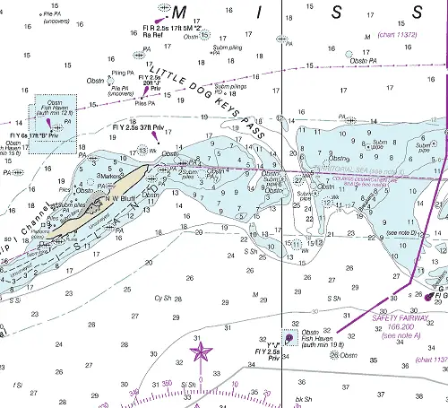
NOAA Chart #11373 - Mississippi Sound and Approaches is suggested for the approach with NOAA Chart #11372 - Dog Keys Pass to Waveland is suggested for the entrance.
The entrance channel intersects with the Gulf Intracoastal Waterway 4.5 NM above the pass at MM "73.1 EHL" near Lighted Beacons (Fl G 2.5s 17ft 3M "41") and (Iso R 6s 17ft 4M "42").
Approach
The approach to the entrance channel is unmarked and deep with depths ranging from 26 to 39 feet to the entrance bar. A marked fish haven covered 19 feet lies 2.5 NM south of the entrance.
Prominent on the approach are a tank and radio tower at Ocean Springs, five tanks at Keesler Field, the Biloxi Lighthouse and several large hotels in and west of Biloxi. Biloxi Light (Oc 4s 61ft) located at (30°23'42"N., 88°54'06"W.), is shown from a 53-foot white conical tower with black balustrade on the shore in the southwest part of Biloxi proper.
Entrance
The natural entrance channel has charted depths of 11 to 27 feet and is unmarked. Shoals covered 3 to 9 feet line both sides of the pass. Numerous unmarked submerged pipes and obstructions are in the vicinity of the pass.
Cautions
A visible wreck was reported about 1.5 miles southeast of Biloxi Channel Light 2, in 30°20.2'N., 88°53.6'W. Shoals covered 3 to 9 feet line the entrance channel. Many unmarked submerged pipes and obstructions are in the area of the entrance channel.
Tides & Currents
Tidal range at Dog Island Pass is about 1.6 feet.
Ship Island Pass
Ship Island Pass lies immediately west of Ship Island, about 50 NM west of Mobile Bay entrance and 11 NM north of the northernmost of the Chandeleur Islands. The pass is best approached from the Gulf of Mexico through the charted safety fairways. Ship Island Pass is the only deep draft access to Gulfport, MS.

NOAA Chart #11373 - Mississippi Sound and Approaches is suggested for the approach with NOAA Chart #11372 - Dog Keys Pass to Waveland is suggested for the entrance.
The Gulf Intracoastal Waterway can be intersected 4.5 NM above the pass at MM "73.1 EHL" near Lighted Beacons (Fl G 2.5s 17ft 3M "41") and (Iso R 6s 17ft 4M "42").
Approach
The approach is marked by buoy (RW "GP" Mo (A) AIS) located 8.2 NM southeast of the entrance. The approach from the Gulf of Mexico is through a dredged channel marked by lighted buoys and ranges. The approach channel is deep with a project depth of 38 feet in the dredged channel.
Prominent on the approach is Ship Island Light (Fl 6s 82ft 6M) on a skeleton tower located on a skeleton tower at (30°12’45"N / 88°57’59"W). (3) 270 foot tall gantry cranes and 150 foot tall silos located on the western mole in Gulfport. There are various tall buildings and a few water tanks also visible. An aviation light is shown from a 62-foot tower at the municipal airport.
Entrance
The entrance at Ship Island Pass is well-marked by lighted buoys, and lighted ranges. Gulfport Ship Channel then continues another 5 miles through Mississippi Sound to Gulfport Harbor Basin. Federal project depths are 38 feet for Ship Island Bar Channel, 36 feet for Gulfport Ship Channel, and 32 to 36 feet for the Anchorage Basin.
Spoil areas and shoals line both sides of the entrance. Numerous wrecks and obstructions lie just outside the marked entrance channel.
Cautions
Ship Island was cut into two parts by Hurricane Camille in 1969. The water between the existing parts is shoal with depths of 2 to 5 feet with much of it having not been surveyed. The shoal off the westend of Ship Island at West Point is moving west and is unmarked. Mariners should use caution if passing between the shoal and the edge of Gulfport entrance channel.
Tides & Currents
The tidal range is about 1.7 feet, but the tides are greatly affected by the winds. NE to S winds raise the level of the water, and SW to N winds lower the level. A continued norther makes a current on Ship Island Bar of as much as 3 knots. Current velocities up to 1.5 knots have been measured in Ship Island Pass during normal weather.
Cat Island Pass
Cat Island Channel and its extension South Pass, lying between Cat Island and Isle au Pitre, is the furthest western pass between the Gulf of Mexico and Mississippi Sound. The passage is little used, except by small local craft; the chart is the best guide to navigating this pass.

NOAA Chart #11373 - Mississippi Sound and Approaches is suggested for the approach with NOAA Chart #11371 - Lake Borgne and Approaches is suggested for the entrance.
The Gulf Intracoastal Waterway can be intersected 8.0 NM above the entrance at MM "55.0 EHL" near unlighted buoy (G C "25").
Approach
The approach is unmarked with depths of 8 to 20 feet. There are numerous wrecks and obstructions in the approach and careful navigation is strongly recommended.
Entrance
The entrance channel is unmarked with depths of 10 to 41 feet being found with careful navigation. Shoals line both sides of the entrance covered 3 to 6 feet.
Cautions
Cat Island Channel and South Pass are bordered by unmarked shoals covered 3 to 6 feet. In 1993, a dangerous wreck was reported at about 30°11'22.2"N., 89°14'18.6"W.
Tides & Currents
The range of tide is about 1.7 feet, but the tides are greatly affected by the winds. Current velocities up to 1.25 knots have been measured in the channel during normal weather conditions.
