BlueSeas
Cruising Guides and Resources
Cruising Resources
A selection of tables, guides, and schedules that we hope will provide you with information not found in the more contemporary cruising / navigation guides you are used to.
What we hope you will find in these pages is the information you will need to assist you in planning your next voyage. You know, the part about actually getting there.
What you won’t find is glitzy photographs, the amenities available at the local marinas, or which restaurant serves the coldest beer. Not saying that cold beer isn’t important mind you, but that’s not our aim here. Hell, what good is cruising without a little sense of adventure and discovery.
Cruising and Navigation Guides
AICW Cruising Guide - Norfolk to Key West
GICW Navigation Guide from Florida to Texas
Okeechobee Waterway Passage Guide
Atlantic Intracoastal Waterway
(Norfolk, VA to Key West, FL)
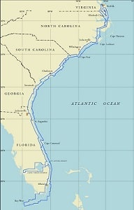 A cruising and navigation guide to the AICW’s 1,002 NM (1,153 SM / 1,856 KM) route along the east coast of the United States. Including navigational charts, aids to navigation, distances and mileages, communications, bridges and locks along with their schedules and restrictions from Norfolk, VA to Miami, FL and then onto Key West.
Updated Semi-Annually, this information is believed to be accurate as of July 2026.
Atlantic Intracoastal Waterway (AICW) Navigation and CruisingThe Gulf Intracoastal Waterway
(Punta Rassa, FL to Brownsville, TX)
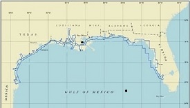 The GICW navigation and cruising guide discusses the 1,190 NM (1,369 SM / 2,203 KM) route from its intersection with the Okeechobee Waterway at Punta Rassa, FL westward to Brownsville, TX. Included are aids to navigation, charts, distances and mileages, communications, bridges and locks along with their schedules and restrictions along the waterway.
Updated Semi-Annually, this information is believed to be accurate as of July 2026.
Gulf Intracoastal Waterway (GICW) Navigation and CruisingThe Okeechobee Waterway
(Stuart, FL to Punta Rassa, FL)
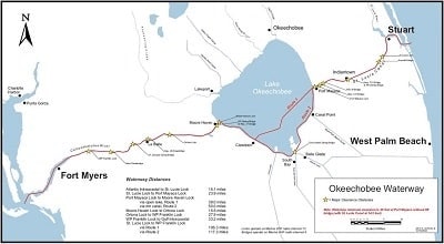 A cruising and navigation guide to the OWW’s 134 NM (156 SM / 249 KM) cross Florida route. From its intersection with the Atlantic Intracoastal Waterway in Stuart, FL to its intersection with the Florida Gulf Intracoastal Waterway at Punta Rassa, FL. Navigational charts, aids to navigation, distances and mileages, communications, water depths, and bridges and locks with their schedules, and restrictions along the waterway.
Updated Semi-Annually, this information is believed to be accurate as of July 2026.
Okeechobee Waterway Cruising and Navigation GuideNew Jersey Intracoastal Waterway
(Manasquan, NJ to Cape May, NJ)
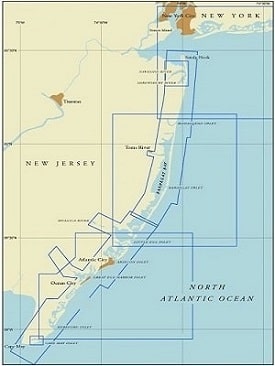 A cruising guide to the NJICW’s 102 NM (118 SM / 190 KM) inside passage that generally parallels the coastline. Stretching from its intersection with the Atlantic Ocean at Manasquan Inlet (≈ 40 NM south of New York City) in New Jersey south to its intersection with the Delaware Bay at North Cape May, NJ (2 miles north of Cape May Light). Navigational charts, aids to navigation, distances and mileages, communications, water depths, and bridges and locks with their schedules, and restrictions along the waterway. The New Jersey Iintracoastal Waterway is typically open for navigation year round.
Updated Semi-Annually, this information is believed to be accurate as of
July 2026.
New York State Canal System
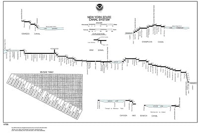 Transit and navigation information on the major canals (Erie, Champlain, Oswego, and Cayuga-Seneca) that make up the New York State Canal System. Included are: Lock information, distances, bridge clearances, channel depths, transit times, and costs, for the 524 miles, 57 locks, and 16 lift bridges that make up the NYSCS. Also included is information on the Federal Lock at Troy, NY.
The NYSCS is typically open for navigation from May through October or November of each year.
The New York State Canal System Cruising and Navigation GuideRichelieu River - Chambly Canal System
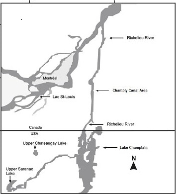 Transit and navigation information for the Richelieu - Chambly - St. Ours canals. Included are: Lock information, distances, bridge clearances, channel depths, transit times, and costs, for the 68 nautical miles and 10 locks that make up the Richelieu - Chambly passage.
The Richelieu - Chambly is typically open for navigation from mid-May through mid-October of each year and offers the boater an alternative passage into and out of the Great Lakes via Lake Champlain and the St. Lawrence River.
Richelieu River - Chambly Canal Guide
Locking Through the Welland Canal
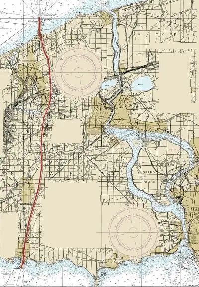 The Welland Canal is a ship canal available to pleasure boats upbound or downbound from Lake Erie to Lake Ontario. It runs approximately 27 miles (42 km) from Port Colborne, Ontario on Lake Erie to Port Weller, Ontario on Lake Ontario.
The canal's Lake Erie (southern) terminus, at Port Colborne, is 326.5 feet (99.5 m) higher in elevation than the Lake Ontario (northern) terminus at Port Weller. The canal is comprised of eight locks, taking vessels an average of 11 hours to traverse the canal's length.
In the interest of safety, craft of less than 6 m (20 feet) in length or 900 kg (1 ton) in weight are not permitted to transit through the Seaway locks.
Pleasure craft operators are reminded that the Seaway is primarily a commercial navigation route and that they should expect delays of varying length caused by the demands of commercial navigation at the locks.
Welland Canal Navigation & Transit Information
Cape Cod Canal
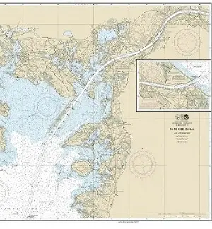 Navigation and passage information for the Cape Cod Canal. Including: Distances, bridge clearances, channel depths, speeds, and transit times. The CCC is a 15.8 nautical mile sea level passage between Cape Cod Bay to the east and Buzzards Bay to the west.
The Cape Cod Canal is typically open for navigation year around and provides the mariner with a time saving shortcut when heading north or south along the New England coast.
New York's East River
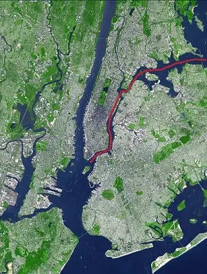 A tidal strait rather than a river, the East River is 14 nautical mile passage connecting New York Bay with Long Island Sound while carrying you through the heart of New York City.
Among some of its most endearing features are: Strong current flows, large commercial marine traffic, heavy volumes of recreational boaters during the summer months, the occasional security zone (in the vicinity of the United Nations), and of course you get an up close and personal view of the infamous "Hell Gate."
I mean really, what more could you ask for?
Chesapeake and Delaware Canal
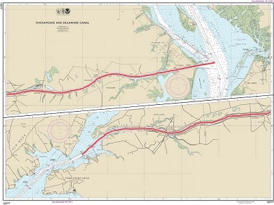 Navigation and passage information for the C & D Canal. Including: Distances, bridge clearances, channel depths, speeds, and transit times. The C & D Canal is a 15.3 nautical mile sea level canal between Reedy Point, DE to the east and the Elk River, MD (Upper Chesapeake Bay) to the west.
The Chesapeake and Delaware Canal is typically open for navigation year around and provides a time saving shortcut when bound for Baltimore, Philadelphia, the Delaware Capes, or the Upper Chesapeake Bay.