Whether you are sailing along the Gulf Coast of Texas or making use of the Texas Gulf Intracoastal Waterway, a number of Entrances, Inlets, and Passes exist between the offshore waters of the Gulf of Mexico and the inland waters of Texas.
At last count, in January 2020, there were 15 entrances, inlets, or passes found along the Texas coastline. Beginning at Sabin Pass at the Louisiana/Texas Border southwest to the Rio Grande River at the Texas/Mexican Border, just south of the Brazos Santiago Pass. While all of these inlets provide access to sheltered waters, many are dangerously shallow that should not be attempted without local knowledge. All provide direct access to the Gulf Intracoastal Waterway.
Sabine Pass
Sabine Pass lies on the Texas/Louisiana border about 224 NM west of the approach to Southwest Pass and 50 miles ENE of Galveston Entrance. It provides access to the GIWW, Port Arthur, Port Neches, and Beaumont, TX.
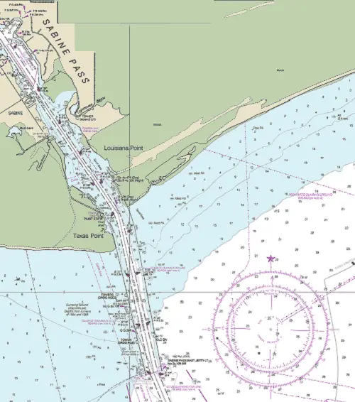
NOAA Chart #11341 - Calcasieu Pass to Sabine Bay is suggested for the approach to Sabine Pass while NOAA Chart #11342 - Sabine Pass and Lake is suggested for the entrance.
The Gulf Intracoastal Waterway is found 13.7 NM above the entrance at (MM "288.6 WHL").
Approach
The approach is marked by buoy (RW "SB" Mo (A) located at 29°25’01"N., 93°40’01"W) 16.0 NM SSE of the entrance. The approach channel is deep (38+ feet mid-channel) and well-marked with lighted buoys and lighted ranges.
Prominent on the approach is Sabine Bank Light (Q 30ft 5M) and the Sabine Pass East Jetty Light (Iso 2s 42ft 8M located at 29°38’41"N / 93°49’22W).
Entrance
The entrance is protected by jetties to the east and west extending over 2.2 NM into the gulf from the shoreline. The jetties seaward ends are marked by AIS transponders and the east jetty shows a lighted beacon (Iso 2s 42ft 8M). It is deep (40+ feet mid-channel) and well-marked with lighted buoys and range lights.
Cautions
Offshore oil well structures, Sabine Bank, and the spoil dumping grounds on the west side of the approach channel reported between Sabine Bank Channel Lighted Buoys 17 and 18, and between Sabine Bank Channel Lighted Buoys 33 and 34; extreme caution is advised.
The depths in the entrance channel may be reduced as much as 3 feet during northers.
Tides & Currents
The range of tide at the entrance to Sabine Pass is 2.5 feet. The currents off the entrance of Sabine Pass are dependent upon the direction and velocity of the wind. The tidal current between the jetties at averages 1.1 knots on the flood and 1.6 knots on the ebb, but velocities up to 2.5 knots have been observed in Sabine Pass.
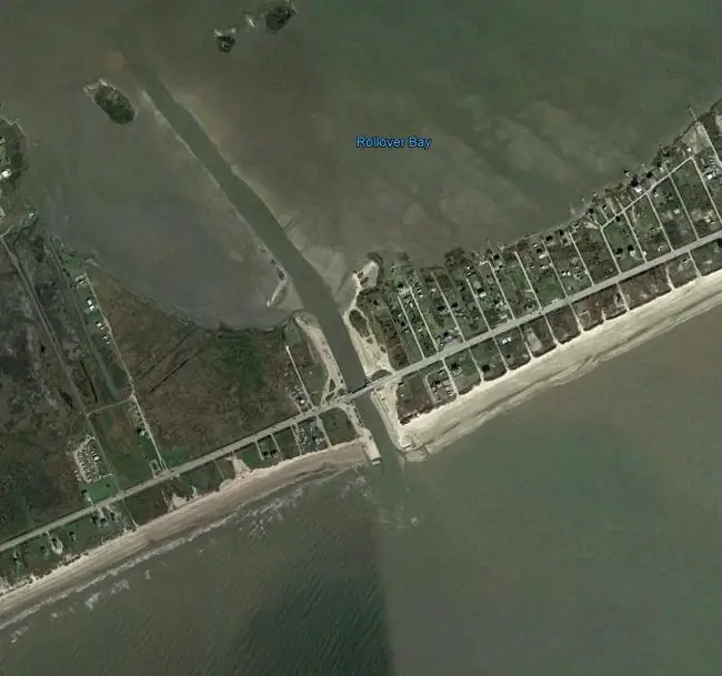
Rollover Pass Inlet
Rollover Pass is an inlet from the Gulf of Mexico into East Bay and lies 15.6 NM NNE of the Galveston Entrance Approach Buoy. The inlet is not navigable for even the smallest of vessels due to strong tidal currents, obstructions, and a shifting bottom.
Galveston Entrance
Found 53.5 NM WWS of Sabine Pass Approach Buoy, Galveston Entrance offers access to Galveston, the GIWW, Texas City, and Houston, TX.
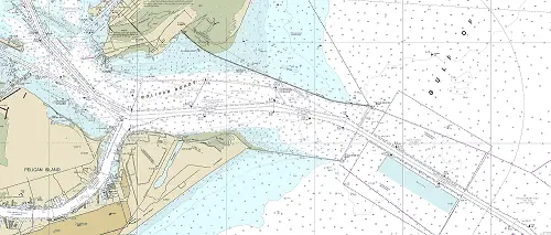
NOAA Chart #11323 - Approaches to Galveston Bay is suggested for the approach to Galveston while NOAA Chart #11324 - Galveston Bay Entrance is suggested for the entrance.
The Gulf Intracoastal Waterway intersects at 7.7 miles above the entrance at (MM “350.8 WHL”). An alternate GICW channel also intersects 5.3 miles above the entrance at (MM “352.3A WHL”).
Approach
The approach to Galveston is marked by lighted buoy RW "GA" Mo (A) at 14.7 NM and lighted buoy RW "GB" Mo (A) is at 9.2 NM, both southeast of the entrance.
Prominent on the approach are a 363 foot building south of the entrance on Galveston Island and an abandoned lighthouse on the north side of the entrance.
Entrance
The Galveston Entrance lies between two converging stone-rubble jetties that are about 1.2 miles apart at the outer ends. North Jetty Light (Iso R 6s 30ft 6M "6A") and South Jetty Light (Iso G 6s 30ft 6M "5A") are displayed on towers on the seaward ends.
The entrance is deep (40+ feet) and well-marked with lighted buoys and lighted ranges. The entrance opens into Bolivar Roads a large deep water area in the entrance between Bolivar Peninsula to the north and Galveston Island to the south.
Cautions
A considerable number of unmarked dangerous wrecks exist in the approaches to Galveston Bay. A spoil bank is south of Galveston Bay Entrance Channel, just outside the jetties. Mariners should be alert to the possibility of strong cross-currents in the Galveston Bay Entrance Channel; caution is advised.
Tides & Currents
The mean tidal range at the entrance is 1.0 feet. The effect of the wind on the water level in this area and adjoining bays may be considerable. A level 2 to 4 feet above mean low tide may result from a strong wind blowing continuously for several days from the east and southeast. A strong wind blowing steadily from the north for several days may lower the water to a level 2 or 3 feet below mean low tide.
The currents are also modified frequently by the winds. East or southeast winds may cause a continuous flood current between the jetties at the entrance for a period of a day or more, and west or northwest winds sometimes set up a continuous outgoing current for a similar period. The average velocity of the current between the jetties at strength is 1.7 knots on the flood and 2.3 knots on the ebb.
San Luis Pass
San Luis Pass, 27.6 NM southwest of Galveston Entrance, has an unmarked channel approximately 0.2 mile wide. The entrance channel leads in a northwesterly direction from the Gulf of Mexico and passes between the shoals of Galveston Island and San Luis Island.
NOAA Chart #11321 - San Luis Pass to East Matagorda Bay is suggested for the approach to Galveston while NOAA Chart #11322 - Galveston Bay to Cedar Lakes is suggested for the entrance.
The Gulf Intracoastal Waterway can be intersected 5.7 NM above the entrance at (MM "382.7 WHL").
Approach
The approach is unmarked and shallow with depths of 0.5 to 5.0 feet.
Entrance
The entrance is unmarked and subject to continual change. A fixed highway bridge and causeway crosses San Luis Pass at the entrance; clearance is 29 feet.
Cautions
In 1981, the approach and entrance had a reported controlling depth of 0.5 feet. It is not recommended for strangers. The shoal waters of West Bay and Christmas Bay limit passage to shallow draft vessels only.
Freeport Harbor Entrance (Brazos Harbor Inlet)
Freeport Harbor lies 40 NM southwest of Galveston entrance and affords access to the GICW, Freeport, TX, and the Brazos River.
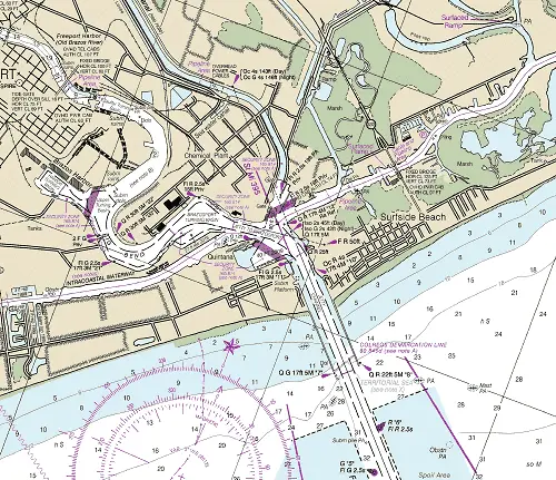
NOAA Chart #11321 - San Luis Pass to East Matagorda Bay is suggested for the approach to Freeport while NOAA Chart #11322 - Galveston Bay to Cedar Lakes is suggested for the entrance.
The Gulf Intracoastal Waterway is found about 1.2 NM above the entrance near (MM "395.1 WHL").
Approach
The approach is marked by lighted buoy (RW "FP" Mo(A) - AIS) lying 4.3 southeast of the entrance at 21°52’37" N / 095°14’09".
The approach channel is deep (40+ feet) and well-marked with lighted buoys and a lighted range.
Prominent on the approach are the buildings, lighting, flares, and tanks of Dow Chemical Plant. By day, the State Route 332 fixed highway bridge crossing the Intracoastal Waterway is also prominent.
Entrance
The entrance lies between (2) parallel jetties marked on their seaward ends by lighted beacons; (Q G 17ft 5M "7") and (Q R 22ft 5M "8").
The entrance is likewise deep and well-marked by lighted buoys and a lighted ranges
Cautions
About 6 miles southwest of the entrance to Freeport Harbor, Brazos River has generated a shoal extending about 5 miles into the Gulf off the mouth of the river. This area is foul and should be given a wide berth. It is reported that several vessels have stranded in this vicinity and that the depths are considerably less than charted.
Oil drilling structures may be erected in the Gulf near the approach to Freeport Harbor. Mariners should be on the lookout for these structures and give them a wide
berth.
Tides & Currents
The current off the entrance of Freeport Harbor generally sets to the west, with a countercurrent near the beach. The bar is rough with an east breeze.
Strong crosswinds and currents at the jetty entrance make navigation difficult for larger vessels. Difficulty in navigation is experienced with larger vessels at the
junction with the Intracoastal Waterway when strong currents are flowing from the canal.
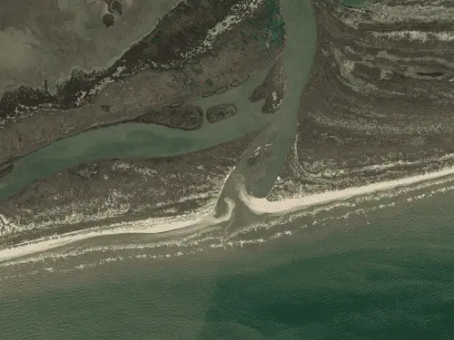
Brazos River Entrance
Brazos River Entrnace is found about 7.6 NM west of Freeport Harbor’s Approach Buoy.The mouth of the river is not used as an entrance due to being foul with logs and shoaling.
NOAA Chart #11321 - San Luis Pass to East Matagorda Bay is suggested for the approach to the Brazos River while NOAA Chart #11322 - Galveston Bay to Cedar Lakes is suggested for the entrance.
The Gulf Intracoastal Waterway is found about 1.3 NM above the entrance near (MM "440.7 WHL").
Approach
The approach is unmarked and over a bar with shoals, unmarked wrecks, snags, and obstructions.
Entrnace
The entrnace is likewise shoal with unknown depths and an unmarked wreck lying mid-channel.
Cautions
The Brazos River Entrnace should be considered unsafe for any but those with strong local knowledge.
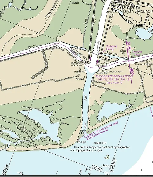
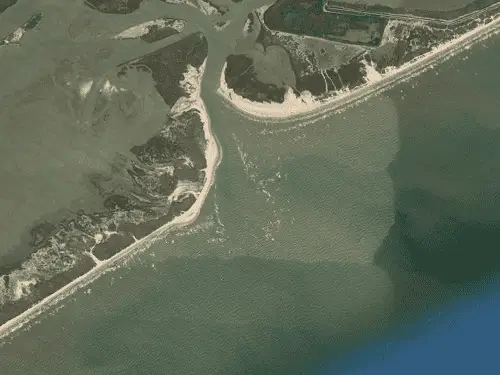
San Bernard River Entrance
The San Bernard River flows into the Gulf 3.5 NM southwest from the mouth of Brazos River. It allows access to the GIWW and Rivers End, TX.
NOAA Chart #11321 - San Luis Pass to East Matagorda Bay is suggested for the approach to San Bernard River while NOAA Chart #11322 - Galveston Bay to Cedar Lakes is suggested for the entrance.
The Gulf Intracoastal Waterway is found about 1.4 NM above the entrance near (MM "405.0 WHL").
Approach
The approach is unmarked and over a bar with shoals and unmarked wrecks.
Entrance
The entrance is obstructed at the mouth by a shifting sandbar over which the channel depths vary from 3 to 5 feet.
Cautions
In 2018 depths of 3 feet were reported mid channel. The Brazos River Entrnace should be considered unsafe for any but those with strong local knowledge.
Caney Creek Entrnace
The entrance to Caney Creek was reported closed to navigation.
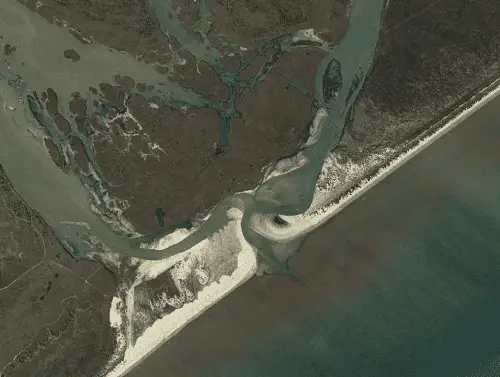
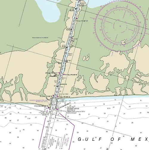
Colorado River Discharge Channel
The Gulf entrance to the Colorado River Discharge Channel is located 42.9 NM southwest of the Freeport Approach Buoy and 23 NM northeast of the Matagorda Bay Approach Buoy. It affords access to the GIWW and Matagorda, TX.
NOAA Chart #11316 - Matagorda Bay and Approaches is suggested for the approach to Port O’Connor while NOAA Chart #11319 - Cedar Lakes to Espiritu Santo Bay is suggested for the entrance.
The Gulf Intracoastal Waterway can be intersected 4.5 NM above the entrance near (MM "471.1 WHL").
Approach
The approach is unmarked.
Entrance
The entrance is protected by jetties marked by lighted beacons at the outer ends. The entrance is subject to frequent change; caution and local knowledge are advised.
Cautions
Oil platforms exist in the vicinity of the approach, caution is advised>
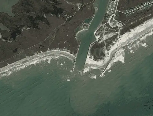
Matagorda Bay Entrance
Matagorda Bay Entrance is found 63 NM SW of Brazos Harbor Entrance. It affords access to the GIWW, Port Lavaca, and Point Comfort, TX.
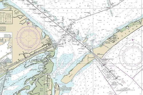
NOAA Chart #11316 - Matagorda Bay and Approaches is suggested for the approach to Port O’Connor while NOAA Chart #11317 - Matagorda Bay is suggested for the entrance.
The Gulf Intracoastal Waterway can be intersected 4.5 NM above the entrance near (MM "471.1 WHL").
Approach
The approach is marked by lighted buoy (RW "MSC" Mo (A)) approximately 17.7 NM SSE of the entrance at (28°12’01" N / 96°05’13" W) and by lighted buoy (RW "MB" Mo (A)) lying about 2.6 NM SSE of the entrance at (28°23’01" N / 96°17’01" W).
The approach is deep with 35 feet mid-channel. It is well-marked with lighted buoys and a lighted range once inshore of buoy RW ”MB” Mo (A) buoy.
Entrance
The entrance is between jetties. The northeastern jetty is marked by Matagorda Bay Entrance Light (Fl 10s 64ft 5M) at (28°25’18" N / 96°19’06" W).
The entrance is deep with a least project depth of 36 feet and is well-marked with lighted buoys and a lighted range.
Cautions
Strong currents may be encountered in the vicinity of the entrance. Large whirlpools have been documented at the channel width transition points.
Tides & Currents
Strong current flows (8+ knots) can be found at the peak of the flood or ebb currents in the entrance
Pass Cavallo Inlet
Pass Cavallo is found 4.2 NM WSW of the Matagorda Bay Entrance. The pass is about 0.4 NM wide between Matagorda Island and Matagorda Peninsula and not recommended for strangers.
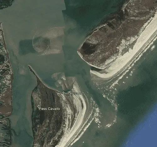
NOAA Chart #11316 - Matagorda Bay and Approaches is suggested for the approach to Pass Cavallo while NOAA Chart #11317 - Matagorda Bay is suggested for the entrance.
Approach
The approach is unmarked and is obstructed by a bar that is subject to frequent changes in location and depths. Reported depths of 3 to 8 feet are reported over the bar.
Prominent on the approach is Matagorda Light (Fl 3s 90ft Priv) located approximately 3.3 NM SSW of the Pass Cavallo Entrance at (28°20’18" N / 095°25’25" W).
Entrance
The entrance is also unmarked and subject to the same conditions as the approach with wrecks and breakers across the entrnace.
Cautions
When a sea or swell is running outside, there is virtually a continuous line of breakers across the bar.
The pass is subject to continual change and swift currents. DO NOT NAVIGATE in or through the area without absolute knowledge of channel location and depths.
Tides & Currents
The mean range of tide in Pass Cavallo is 1.4 feet and is largely dependent on the winds. During strong northers water levels may be depressed 2 feet or more. The tidal current in Pass Cavallo is believed to attain a velocity of 2 knots with currents of 5 knots reported. It is reported to be very strong in the land cut through Matagorda Peninsula, especially on the runoff of the ebb after strong Southerly winds.
Cedar Bayou Inlet
Located 35.4 NM WSW of Pass Cavallo and 17.0 NM NNE of Aransas Pass, Cedar Bayou Inlet is not recommended for navigation.
NOAA Chart #11313 - Matagorda Light to Aransas Pass is suggested for the approach and entrance to Cedar Bayou.
The Gulf Intracoastal Waterway is accessible for vessels drawing 2 feet or less.
Aransas Pass
Aransas Pass is located 154 NM southwest of Galveston Entrance and 113 NM north of the mouth of the Rio Grande River. It affords access to the GIWW, Aransas and Corpus Christi, TX.
NOAA Chart #11307 - Aransas Pass to Baffin Bay is suggested for the approach to Corpus Christi while NOAA Chart #11309 - Corpus Christi Bay is suggested for the entrance.
The Gulf Intracoastal Waterway can be intersected in two different locations:
1.5 NM above the entrance (GIWW Alternate Channel) or 6.7 NM above the entrance at (MM "533.0 WHL") near lighted beacon (Fl G 4s 17ft 4M "23").
- The first intersection (GICW Alternate Channel) is located 1.5 miles above the entrance at (MM “534.3(A) WHL”).
- The second intersection (GICW) is 6.7 miles above the entrance at (MM “533.0 WHL”) near lighted beacon (Fl G 4s 17ft 4M "23").
Approach
The approach to Aransas Pass is marked by buoy (RW "AP" Mo (A)), 4.7 NM southeast of the entrance at (27°47’34" N / 095°57’22" W). The approach channel is deep (40+ feet) and well-marked with lighted buoys and a lighted range.
Prominent on the approach is a water tank (daytime) and microwave towers (nighttime) all close southwest of the approach channel. The (Fl W&G) rotating aerolight at the
naval air station on Encinal Peninsula has been reported visible from the Gulf of Mexico.
Entrance
The entrance channel is deep (40+ feet) mid-channel to Corpus Christi, it is well marked with lighted buoys, lighted beacons, and a lighted range. It is protected by jetties on both sides with San Jose Island to the north of the entrance and Mustang Island to the south.
Cautions
A number of oil platforms 2.6 NM SSW of the approach buoy should be given a wide berth.
Tides & Currents
The currents at times have velocities exceeding 2.5 knots in Aransas Pass; they are greatly influenced by winds. It is reported that the currents outside Aransas Pass are variable. Southbound currents when reinforced by northerly winds have produced a drift that has been reported as high as four knots across the mouth of the
jetties.
Winds from any easterly direction make a rough bar and raise the water inside the entrance as much as 2 feet above normal. Winds from any westerly direction have an opposite tendency.
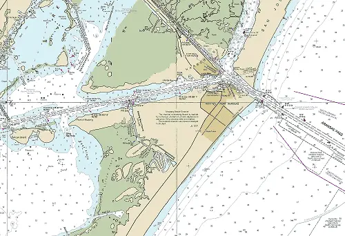
Port Mansfield
Port Mansfield Inlet is found 75.8 NM southward of Aransas Pass Approach Buoy and 31.7 NM northward of Brazos Santiago Pass Approach Buoy. It allows access to the GIWW and Port Mansfield, TX.
NOAA Chart #11304 - Northern Part Laguna Madre is suggested for the approach to Brazos Santiago Pass while NOAA Chart #11306 - Laguna Madre (Middle Ground to Chubby Island) is suggested for the entrance.
The Gulf Intracoastal Waterway can be intersected 7.4 NM miles above the entrance jetties at (MM 629.8 WHL) near lighted beacon (Fl (2+1) R 6s 17ft 4M "PM"
).
Approach
The approach is unmarked. Vessels should approach Port Mansfield through the Port Mansfield Safety Fairway.
Entrance
The entrance is marked on the seaward ends of the north and south jetties with lighted beacons. (Fl R 2.5s 25ft 5M "2") marks the north jetty and (Fl G 2.5s 25ft 5M "3" marks the south jetty. The jetties are reported to be in extremely poor condition. Lighted and unlighted beacons and buoys mark the cut along the 8.4 NM dredged channel to Port Mansfield.
Controlling depths in the entrance channel are 8 feet mid channel.
Cautions
Due to recent hurricane activity in the Gulf of Mexico resulting in severe shoaling, Port Mansfield Inlet is not recommended without local knowledge. Above mile 6.0 shoaling of the channel has occured; March 2018 the controlling depth was reported to be 4 feet mid-channnel.
Tides & Currents
The mean tidal range at the entrance averages about 1.2 feet. Tidal currents typically run directly between the jetties on both the flood and the ebb.
Brazos Santiago Pass
Located 6.6 NM north of the U.S./Mexican Border and 31.7 NM SSE of Port Mansfield Entrance. The Brazos Santiago Pass provides access to the southern tip of South Padre Island, The GIWW, Port Isabel, and Brownsville, TX.
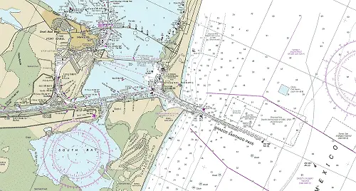
NOAA Chart #11301 - Laguna Madre is suggested for the approach to Brazos Santiago Pass while NOAA Chart #11302 - Stover Point to Port Brownsville is suggested for the entrance.
The Gulf Intracoastal Waterway can be met at (MM "668.0 WHL"), 3.5 NM above the entrance near lighted beacon (Fl G "1").
Approach
The approach is marked by a buoy (RW "BS" Mo (A) located at 26°03’56"N / 97°06 rsquo;35"W) lying about 3.5 NM east of the entrance jetties.
The approach channel is deep (40+ feet) and well-marked with lighted buoys and a lighted range.
Prominent on the approach to Brazos Santiago Pass is the radio antenna at South Padre Island Coast Guard Station on the north side of the pass, as well as a water tank near 26°04’15" N / 97°13’10" W) and Port Isabel Light (F 91ft) shown from the white conical brick tower located at (26°04’36",N / 97°12’24" W).
Entrance
The entrance has been improved with (2) rubble mound jetties to the north and south, extending nearly 1 mile into the Gulf of Mexico. The entrance is deep with a reported project depth of 44 feet and is well-marked with lighted buoys and range lights.
Cautions
An unmarked dangerous wreck lies 4.5 miles north of Brazos Santiago Pass approach buoy.
Tides & Currents
The mean tidal range at the entrance averages 1.2 feet. Tidal currents of 6 knots have been reported in the vicinity of Brazos Santiago Pass and Port Isabel which may cause strong cross currents on the Intracoastal Waterway at about MM "665.1 WHL", especially with a flood tide and strong southeast winds. Caution is advised for larger vessels transiting between Port Isabel and Long Island.