Entrances, Inlets, & Passes - Florida’s East Coast
Florida’s East Coast Entrances, Inlets, & Passes
Whether you are making use of the Atlantic Intracoastal Waterway or sailing coastwise along Florida’s East Coast, numerous Entrances, Inlets, or Passes exist between the deep waters of the Atlantic Ocean and the inland waters of Florida.
At last count, in January 2020 there were 19 entrances, inlets, or passes found along the east coast of Florida. Beginning at St. Marys Entrance at the Georgia/Florida Stateline in the north and Government Cut in Miami to the south. While all of these inlets provide access to sheltered waters, many provide access to the Atlantic Intracoastal Waterway.
Many of these entrances and inlets are only suitable for very shallow draft vessels and strong local knowledge, some can be considered navigable for most vessels. We have listed them below along with useful information on each to aid you in deciding if you wish to use a particular inlet.
Entrances, Inlets, and Passes
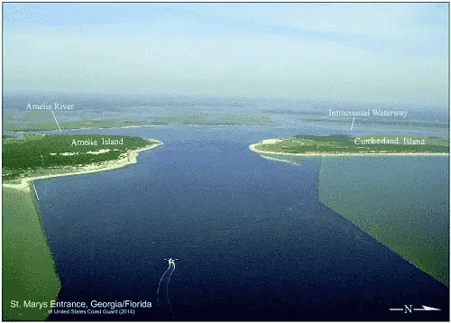
St. Marys Entrance
Lying on the Florida/Georgia State Line, St. Marys Entrance is 19.9 NM southward of St. Simons Sound, GA Approach Buoy "STS", and 19.7 NM northward of St. Johns River Entrance, FL Approach Buoy "STJ."
The St. Marys Entrance affords access to Fernandina Beach, FL, St. Marys and Kings Bay, GA and the Atlantic Intracoastal Waterway.
The Atlantic Intracoastal Waterway is intersected 2.5 NM above the entrance near lighted buoy (Y "E" Fl Y 2.5s) at (MM "713.7").
Approach
The approach to St. Marys Entrance is marked by lighted buoy (RW “STM” Mo(A) AIS) and is located 8.2 NM east of St. Marys Entrance at (30°42’54" N / 81°14’39" W). The approach channel through the bar is deep (40+ feet)and well-marked with lighted buoys and ranges.
Prominent on the approach is Amelia Island Light (Fl 10s 107ft 19M) located 2 NM southward of the entrance. It is reported that the light is difficult to distinguish during daytime hours. Also prominent from seaward is a 295 foot-high processing tower southward of the entrance. The tower is marked at night by flashing red lights. Smoke from the stacks of the paper companies at Fernandina Beach and St. Marys make them easily visible from all directions.
Entrance
St. Marys Entrance is between two stone jetties. The jetties are reported to be in very poor condition with both almost entirely submerged at mean high water. The north jetty is marked off its outer end by a lighted buoy (R "2NJ" QR). White buoys with orange bands also mark the approximate location of the north and south jetties. The entrance is deep (40+ feet), wide, and well-marked with lighted buoys and ranges.
Tides & Currents
Tides & Currents - The mean tidal range at the entrance is 5.8 feet. The tidal currents at the entrance have considerable velocity and are dangerous at times. Maximum current velocities are reported to be 2.0 to 3.9 knots in St. Marys Entrance. Freshets in the St. Marys River may cause the ebb to run for 7 to 8 hours. Velocities exceeding 5 knots have been reported to occur.
Cautions
Cautions - Mariners are advised to exercise caution at the entrance. The jetties can be hazardous to navigation when visibility is limited. Currents are strong off the ends of the jetties. The natural channel between the jetties is subject to frequent change.
An ebb current inside the jetties opposed by a moderate to strong easterly wind often creates 4 to 7 foot seas in the entrance.
Nassau Sound Entrance is located 15 NM southward of the St Marys Approach Buoy "STM" and 7.1 NM northward of St. Johns River Approach Buoy "STJ."
Approach
The approach is unmarked and is obstructed by shifting shoals that extend about 1.5 miles seaward and form a shallow bar with depths of 1 to 7 feet. Breakers form across the entire approach. Vessels are advised not to attempt passage through the shoals without local knowledge.
Entrance
The entrance is uncharted and unmarked. It is shallow and shoal with depths of 1/2 to 25 feet. Unmarked wrecks exist in the entrance. It has (2) fixed bridges 1 NM above the entrance with a vertical clearance of 15 feet.
Tides & Currents
The mean range of tide in Nassau Sound is 5.4 feet.
Cautions
Local Knowledge Required.
Dangers
Breaking bar across entire approach and entrance.
Ft. George Inlet
Fort George Inlet is a small inlet 1.5 NM northward of St. Johns River entrance and lying between Little Talbot Island to the north and Fort George Islands to the south.
The inlet changes rapidly due to shifting sands at its entrance and should never be used without local knowledge.
Approach
The approach is unmarked and is obstructed by shifting shoals that extend about 0.7 NM seaward and form a shallow bar with depths of ½ to 3 feet.
Entrance
The entrance is uncharted and unmarked. It is shallow and shoal, frequently going bare at low water. The area is subject to frequent changes. A fixed bridge at the entrance has a vertical clearance of 15 feet. An overhead power cable adjacent to the bridge has a clearance of 40 feet.
Tides & Currents
The mean range of tide at Ft. George inlet is ≈5.0 feet.
Cautions
Local knowledge is required when using this inlet. This inlet should be considered unnavigable for most vessels.
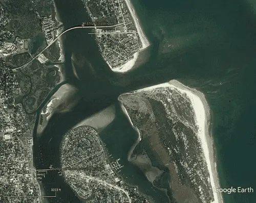
St. Johns River Entrance
St. Johns River Entrance is 19.7 NM SSW of St. Marys Entrance and 28.8 NM northward of St. Augustine Inlet. St. Johns River Entrance provides access to the St. John River, Mayport, the AICW, Jacksonville, and Palatka, FL.
The Atlantic Intracoastal Waterway can be intersected approximately 5.0 NM above the entrance near lighted buoy (G "1" Fl G 4s) at (MM "740.0").
Approach
The approach is marked by a lighted buoy (RW "STJ" Mo(A) AIS) about 3.0 NM east of the entrance jetties located at 30°23’35"N / 081°19’08.398W.
Prominent on the approach is St. Johns Light (Fl(4) 20s 83ft 19M) located at (30°23’10"N., 81°23’53"W. and shown from a white square tower on the beach about 1 NM south of St. Johns River south jetty. Water tanks are prominent along the beaches southward of St. Johns Light.
Entrance
The entrance channel is protected by jetties. It is deep (40 to 50 feet to Pilot Town Cut Range) and 34 to 40 feet beyond. It is well marked with lighted buoys and ranges as far as downtown Jacksonville.
Tides & Currents
The mean range of tide is 4.9 feet at St. Johns River entrance. Strong northerly and northeasterly winds raise the water level about 2 feet at Jacksonville and about 1 foot at Palatka, FL. Strong southerly and southwesterly winds lower the water level about 1 to 1.5 feet, increase the ebb, and decrease or may interrupt the flood.
The tidal currents are strong in St. Johns River as far as Jacksonville. The velocity of the current between the jetties is 2 knots on the flood and 4 knots on the ebb; at Mayport, 2.2 knots on the flood and 4 knots on the ebb; at Mile Point, 2.7 miles above the mouth, about 2.8 knots. At downtown Jacksonville (Commodore Point), the velocity of current is about 1.0 knot. The tidal currents above Jacksonville average less than a knot. The currents in Deep Creek are weak, being due primarily to the winds and tide. The flood is increased by northeasterly and easterly winds and the ebb by southwesterly and westerly winds.
Cautions
The Atlantic Intracoastal Waterway’s junction with the St. Johns River is subject to strong and unpredictable crosscurrents at various stages of the tide.
Dangers
The Bar Pilots report that 1 hour after the beginning of strong winds from anywhere between north through east to south, a very strong current sets up with the wind across the end of the jetties, and the condition is usually dangerous; when such winds reach gale force, the positions of the buoys should not be relied upon as they may drag from station.
St. Augustine Inlet is found 30 NM south of the St. Johns River entrance, 12.6 NM NNW of Matanzas Inlet, and 53.5 NM NNW of Ponce de Leon Inlet and Daytona Beach, FL. The inlet provides access to St. Augustine, Anastasia Island, and the AICW.
The Atlantic Intracoastal Waterway can be intersected about 0.5 NM above the entrance near buoy (G "59" Fl G 2.5s) at (MM "776.4").
Approach
The approach is marked by lighted buoy (RW "STA" Mo(A) WHIS) 1.7 NM east of the entrance at 29°54’ 55" N / 081°15’ 17" W. The shore should be given a berth of at least 2 miles when approaching St. Augustine Inlet in order to stay outside of the outer sea buoy. All other approach buoys are uncharted as the channel shifts frequently.
Prominent on the approach is St. Augustine Light (Fl 30s 161ft 19M) located at 29°53’08" N / 81°17’ 19" W, shown from a conical tower with a black and white spirally banded shaft on the north end of Anastasia Island, 1.5 NM south of the entrance to St. Augustine Inlet. Other prominent features are an elevated water tank just southeast of the light, a radio tower 1.3 miles southward of the light, and the lighted cross and the radio tower in the northern part of the city.
Entrance
The entrance channel to St. Augustine is protected by a jetty on the south side and is subject to frequent changes in depth and direction due to current and storm action. The uncharted entrance channel buoys mark the best water. These aids are moved frequently with changing conditions to mark the channel. Mariners are advised to seek local knowledge prior to entering.
Tides & Currents
Mean tidal range is approximately 4.5 feet.
Cautions
Local knowledge highly recommended for this inlet.
Dangers
Dangerous and shifting shoals extend 1 mile seaward on the approach. It is also common for a breaking sea to exist in the inlet, when there is an outgoing tide with any strong northerly wind.
Matanzas Inlet lies 11 NM southward of St. Augustine Light and 41.4 NM northward of Ponce de Leon Inlet. The inlet is obstructed by a shifting bar, and breakers that extend across the entire entrance in normal weather. It is unmarked and has a fixed bridge across the inlet with a vertical clearance of 10 feet. An overhead power cable crossing on the west side of the bridge has a clearance of 32 feet. Matanzas Inlet is reported to be "Closed to Navigation."
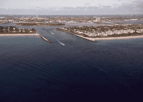
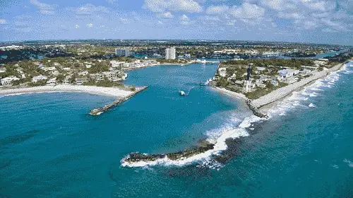
Ponce de Leon Inlet
Ponce de Leon Inlet is found 53 NM southward of St Augustine Light and 41 NM northwestward of Cape Canaveral Light. It affords access to the AICW, New Smyrna Beach and Daytona Beach, FL and is used by both recreational and small commercial vessels.
Inside the inlet the Atlantic Intracoastal Waterway can be intersected in two different places. If northbound, 2.2 NM above the inlet near buoy (R N “2”). If southbound, 1.1 NM below the entrance near buoy (GR C).
Approach
The approach is marked by lighted buoy (R "2" Fl R 2.5s BELL) approximately 1.0 NM east of the entrance located at 29°04’46" N / 080°53’29" W. The approach is deep with a least depth of 14 feet found just off the northern jetty. It is well marked with charted lighted and unlighted buoys.
Prominent on the approach is Ponce de Leon Inlet Light (Fl (6) 30s 159ft 22M) shown from a red brick conical tower located just NNW of the inlet.
Entrance
The entrance is protected by jetties with a channel that leads over a bar. The entrance is deep with a least depth of 9 feet being reported just inside the entrance. The outer end of the north jetty is marked by a light (Q 25ft 5M). The remainder of the entrance channel is reasonably well marked with lighted and unlighted buoys. The inner end of the north jetty is awash. A shoal built out from the south side of the entrance is close aboard the entrance channel with depths of 1 to 4 feet.
Tides & Currents
The current through the inlet is strong. It is reported that the average ebb is 3 knots; however, this can increase to 5 or 6 knots with southeasterly winds.
Cautions
Safe navigation may be hampered by numerous recreational fishing vessels that anchor inside the north jetty. Local knowledge and extreme caution is advised when using this inlet.
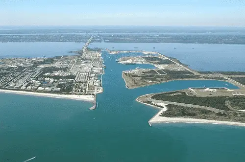
Port Canaveral Inlet is located 150 NM south of the entrance to the St. Johns River and 54.4 NM northward of Ft. Pierce Inlet. It provides access to Cape Canaveral, Merritt Island, the AICW, and Cocoa, FL. Party fishing vessels, cruise ships and many pleasure craft operate from the port.
The Atlantic Intracoastal Waterway can be intersected 8.0 NM above the entrance at (MM "893.8") near lighted beacon (Fl G 4s 12ft 5M "67").
Approach
The approach to Port Canaveral begins 5.7 NM SSE of Cape Canaveral Light. The outer approach limit is unmarked. The approach channel is deep (43+ feet) and well-marked by lighted buoys and ranges.
Prominent on the approach is Cape Canaveral Light (Fl (2) 20s 137ft 24M) located 3.7 NM NNE of the entrance jetties. Many Cape Canaveral launch complex structures and buildings are visible north of the inlet.
Entrance
The entrance channel between the jetties is deep 40+ feet and well-marked by lighted buoys and beacons as well as a lighted range. The head of the inlet is crossed by twin bascule bridges with a closed clearance of 25 feet at the center. Just beyond the bridges is Cape Canaveral Lock used for passage into the Canaveral Barge Canal leading to the Banana River, Indian River, and
Tides & Currents
The Tidal Range is approximately 3.5 feet. There is little to no tidal currents within the entrance or the harbor due to the Canaveral Lock.
Cautions
A Shoal extends southeast from Cape Canaveral approximately 6.5 NM. Caution is advised for approaches to Cape Canaveral from the north through the east. The southeastern and southern extent of the shoal are marked by lighted buoys.
Dangers
Security Zones, Restricted Areas, Hazard Areas, and Danger Areas. These areas extend from Cape Canaveral to the north through east to the southeast.
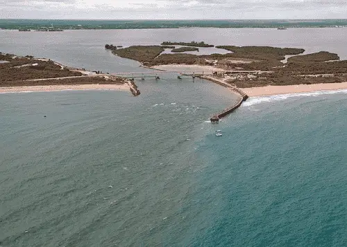
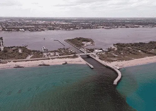
Sebastian Inlet is 36.5 NM southward of Cape Canaveral Light and 24.8 NM NNW of Fort Pierce Inlet. It provides access to the AICW, Roseland, Micco, and Sebastian, FL.
The Atlantic Intracoastal Waterway can be intersected 1.7 NM above the inlet’s entrance at (MM "936.1") near lighted beacon (Fl G 4s 16ft 5M "63")
Approach
The approach is not marked and the inlet is a narrow dredged channel, not distinguishable from any distance offshore except by the highway bridge across the inlet and by the sand spoil bank on the north side which is bare and a little higher than other sand dunes in the vicinity.
Entrance
The entrance is protected by jetties. The entrance is unmarked with the exception of the north jetty which has a private lighted beacon (FL R 4s 27ft). A fixed highway bridge crosses the inlet with a vertical clearance of 37 feet.
Tides & Currents
It is reported that the velocity of the tidal currents reaches 10 knots, and turbulence exists between the bridge and the end of the jetties.
Cautions
Except during flat calms, breaking and confused seas exist off the mouth of the inlet and inside the inlet as far as the bridge.
Reported shoaling exists just north of the south jetty and for about 200 yards to the east of the south jetty. Shoaling also exists in the general area south of the small spoil island between the bridge and the Intracoastal Waterway. Shoals are gradually building up and shifting. Minimum depth in the inlet varies; the bottom is rocky in spots.
Dangers
Sebastian Inlet is dangerous and particularly hazardous to small boats not designed for the open seas. Passage through this inlet is not recommended except by experienced boatmen with local knowledge.
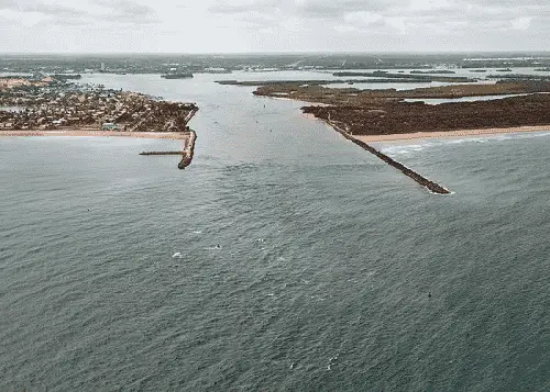
Fort Pierce Inlet
Fort Pierce Inlet is 62 NM southward of Cape Canaveral Light and 33 NM northward of Jupiter Inlet Light. It affords access to the AICW, Ft. Pierce and St. Lucie, FL.
The Atlantic Intracoastal Waterway will be intersected 2.0 NM above the entrance at (MM "965.6") near lighted beacon (Q G 16ft 4M "17").
Approach
The approach is marked by a lighted buoy (R "2" Fl R 4s) located at 27°28’39" N / 080°15’25" W. It is deep with a controlling depth of 24.8 feet mid-channel. It is also well marked with lighted buoys and a lighted range.
Prominent on the approach are several high rise condominiums located 1 mile north of the entrance. A 210-foot meteorological tower 7.2 miles south of the entrance which is marked by a fixed red light about halfway up and a flashing red light on top. The concrete cooling towers of a nuclear power plant about 7.6 miles southward of the entrance.
Entrance
The entrance is protected by (2) rubble stone jetties with revetment extensions. The stone jetties have lighted AIS buoys close to the outer ends. The inlet is deep with least controlling depths of 20.7 feet mid-channel. It is also well marked by lighted buoys and ranges.
Tides & Currents
Care must be exercised in entering this inlet due to the strong currents. In southeasterly weather with an ebb tidal current the entrance is rough. Strong east winds over several days makes the entrance VERY rough, especially with an outgoing tide.
On the flood, there is a very strong set to the north at the seaward end of the south jetty.
The tidal currents in the inlet have a velocity of about 3 knots. The currents run through the cut parallel to the channel and can reach velocities of 4 to 6 knots. From the turn in the channel and along the Inner Range for about 0.8 mile, the current sets at an angle to the channel. At the western end of Causeway Island, where the channel crosses the Intracoastal Waterway, strong cross currents are also encountered with the set to the south on the flood and to the north on the ebb. These currents are influenced by wind and heavy rain runoff or discharge of freshwater from inland areas. Vessels are advised to use caution.
Cautions
The ocean currents typically run across the channel and there is considerable set when entering or leaving.
Dangers
There are a number of unmarked shoals (6 feet) and wrecks in the southern approaches. In the entrance channel, shoaling tends to build southward from the north side of the channel just inside the jetties, as well as abeam Coon Island, and in the turning basin. Local knowledge is advised to determine the extent of shoaling in these areas.
St. Lucie Inlet, lies 20 NM south of Fort Pierce Inlet and 13.5 NM north of Jupiter Inlet Light. It affords access to the AICW, the Okeechobee Waterway, and Stuart, FL.
2.14 NM above the approach buoy is the junction for the Atlantic Intracoastal Waterway and the Okechobee Waterway located near (AICW MM "987.5") and (OWW MM "0.0") close to lighted beacon (Fl R 6s 16ft 5M "240").
Approach
The approach is marked by a lighted buoy (R "2" Fl R 4s AIS) located at 27°10’01" N / 080°08’23" W. The entrance buoys are not charted, as they are frequently moved to mark the best water.
Entrance
The entrance to the inlet is protected by jetties and a detached breakwater and the entrance buoys are not charted, as they are frequently moved to mark the best water. The inner part of the north jetty is in ruins. A rock ledge across the inlet extends south for over 1 mile from the east end of the north jetty ruins. Extensive sandbars are on the north side of the inlet channel from the north jetty to the Intracoastal Waterway. It is reported that shoaling builds up across the channel from both the north and south sides. Depths in the channel vary.
Tides and Currents
It is reported that tidal currents reach a velocity of 7 knots. Currents continue to flow 2 hours after high and low tides. Entrance is easiest just on the flood side of slack water.
Cautions
Passage through St. Lucie Inlet is not recommended without local knowledge of all hazardous conditions. Cross currents at the entrance to St. Lucie River create a hazardous condition for vessels making the short turn from the Intracoastal Waterway.
Dangers
St. Lucie Inlet is dangerous and particularly hazardous to small boats not designed for the open seas. Persons using the inlet should be experienced boatmen and have local knowledge. It is reported that ground swells can make inlet passage impossible for all craft. Breakers occur throughout the entire channel as seas, ground swells and winds increase, particularly on an ebb tide.
Jupiter Inlet
Jupiter Inlet, just south of Jupiter Inlet Light, is 14 NM south of St. Lucie Inlet and 10.7 NM northward of Lake Worth Inlet. The inlet leads to Jupiter Sound on the north and Lake Worth Creek on the south.
The AICW and Jupiter, FL can be accessed here. The Atlantic Intracoastal Waterway is 0.5 NM inside the entrance to the inlet and is intersected at (MM "1004.5") near lighted beacon (FL G 4s 16ft 5M "1")
Approach
The approach is not marked, however on the approach Jupiter Inlet Light (Fl (2) 30s 146ft 25M) is prominent. It is shown from a red brick tower on the north side of the inlet. The light is reported to be obscured by high-rise construction from 231° to 234° when within a range of 5.5 NM.
Entrance
The entrance is protected by a short stone jetty on the north side. (3) private lighted beacons mark the entrance. Beacon (Q R "2") marks the north side of the entrance while (Q) and (Q G "1") marks the south side.
Tides and Currents
Mean tidal range is approximately 1 foot. Tidal currents reach a velocity of 6 knots. Eddies and extreme turbulence accompany flood and ebb tides, particularly near the south jetty.
Cautions
Persons using this inlet should be experienced boatmen and have local knowledge. Breaking and confused seas frequently exist over the sandbars off the mouth of the jetty. Conditions are worst with ebb tide and easterly winds. Near low water, long ground swells and wake from passing vessels can create dangerous waves in seemingly calm seas.
Dangers
upiter Inlet is dangerous and particularly hazardous to small boats not designed for the open seas. A very shallow sandbar extends south and east from the north jetty across the entire inlet. The bar is very deceptive and usually lies 1 or 2 feet below the surface. The openings through the sandbar shift with rapidly changing weather conditions and can be very shallow.
Shallow sandbars have also been reported to exist from the lighthouse through the mouth of the inlet and that a sandbar at the junction of the Intracoastal Waterway and the entrance builds up continuously.
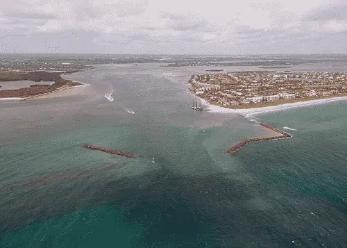
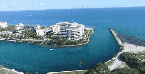
Lake Worth Inlet
Lake Worth Inlet is situated 10.7 NM SSE of Jupiter Inlet and 13.7 NM NNE of Boynton Inlet and affords access to the AICW, the Port of Palm Beach and Riviera Beach, FL.
The Atlantic Intracoastal Waterway is intersected 1.0 NM above the entrance at (MM "1018.8"); just north of lighted beacon (Q G 12ft 4M "1").
Approach
The approach is marked by a lighted buoy (RW "LW" Mo(A) AIS) located 1.1 NM east of the Lake Worth Inlet entrance at (26°46’22" N / 080°00’36" W). The approach is deep and well-marked by lighted buoys and a lighted range.
Prominent on the approach are the many multistoried buildings along the beaches north and south of the inlet. A 42-story condominium 1 mile north of the inlet and the Breakers Hotel 3.5 NM south of the inlet are easily discernable.
Entrance
Lake Worth Inlet’s entrance is a dredged cut through the barrier beach and is protected by two jetties. The entrance is deep with a least depth of 32 feet mid-channel and well-marked by lighted buoys and beacons. The north (right outside) quarter of the entrance channel tends to shoal along the north jetty.
Tides and Currents
Lake Worth Inlet’s mean tidal range is 2.7 feet. The currents in the inlet are strong and must be carefully guarded against. The current velocity is 2.4 knots on the flood and 3.6 knots on the ebb.
Dangers
A reef in the form of a ridge with scattered boulders extends for about 300 yards eastward of Peanut Island about 25 feet north of the improved channel. The reef, with a least depth of about 4 feet over it, is extremely dangerous.
Boynton Inlet is found 13.7 NM SSW of Lake Worth Inlet and 12.6 NM NNE of Boca Raton Inlet. It provides access to the AICW and Boynton Beach, FL. It is a small dredged cut through the outside beach, about 100 feet wide.
The Atlantic Intracoastal Waterway is intersected 0.5 NM above the entrance at (MM "1033.0") near unlighted buoy (R N "46").
Approach
The approach is unmarked with no easily distinguishable landmarks.
Entrance
The entrance channel to the inlet is protected by jetties. The channel is unmarked and reported shoaling exists. The inlet is crossed by a fixed bridge with a vertical clearance of 18 feet and an overhead power cable at the bridge with a clearance of 38 feet.
Tides and Currents
The mean average tide is 2.5 feet. Tidal currents through the inlet reach a reported velocity of 8 knots, and eddies and extreme turbulence accompany flood and ebb tides.
Cautions
Passage through Boynton Inlet is not recommended without complete local knowledge of all hazardous conditions affecting this area. Except during a flat calm, breaking and confused seas exist in the channel from the bridge to the mouth of the inlet.
Submerged rocks are reported to extend 15 feet east of the end of the south jetty and within the inlet, along the north and south jetties, east of the fixed highway bridge, there is a concrete ledge that is just below the surface at high tide.
Dangers
Boynton Inlet is dangerous and particularly hazardous to small boats not designed for open seas. A dangerous wreck is about 1.8 miles south-southeast of the inlet. With an ebb current and easterly winds the inlet is impassible because of breakers at the entrance.
Boca Raton Inlet
Boca Raton Inlet found 12.6 NM south of Boynton Inlet and 5.0 NM north of Hillsboro Inlet affords access to the AICW, Boca Raton, and Deerfield Beach, FL.
The Atlantic Intracoastal Waterway is intersected 0.6 NM above the entrance near lighted beacon (Fl G 4s 16ft 5M "67") at (MM "1048.3").
Approach
The approach is unmarked with a bar covered 4 to 6 feet across the entrance. A hotel in Boca Raton is prominent.
Entrance
The entrance is a narrow dredged cut through the beach and is protected by short jetties marked by private lights. The bar channel shifts with the winds and the inlet is dredged continuously. A bascule bridge spans the inlet with a vertical clearance of 23 feet at the center in the closed position.
Tides and Currents
Tides and Currents - The mean range of tide is 2.6 feet and the tidal currents through the entrance reach a reported 7 knots.
Cautions
Mariners are urged to minimize wake and proceed with caution. Persons using this inlet should be experienced boatmen and should be extremely knowledgeable of the area.
Shoaling exists 30 yards outside of the inlet and also inside the inlet. Depth at low tide varies from 1 to 3 feet. A sandbar protrudes out of water inside the inlet on the north side. A sandbar extends underwater to within 30 feet of the south jetty. Shoaling and sandbars are continually shifting. It is reported that increased shoaling may be expected and that the inlet may occasionally be closed by severe weather.
Except during flat calms, breaking and confused seas may exist at the mouth of the inlet. These breaking seas may extend 200 feet inside the entrance.
Dangers
Dangers - Boca Raton Inlet is dangerous and particularly hazardous to all boats not designed for open seas.
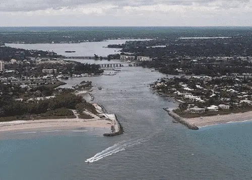
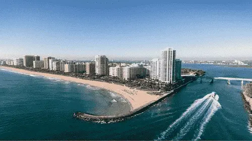
Hillsboro Inlet
Hillsboro Inlet lies 31 NM southward of Lake Worth Inlet and 9.6 NM north of Port Everglades. It affords access to the AICW, Pompano, and Lighthouse Point, FL.
The Atlantic Intracoastal Waterway is intersected 0.3 NM above the entrance at (MM "1053.8") near beacon (R "72"). .
Approach
The approach is marked by a lighted buoy (RW "HI" Mo(A)) located approximately 0.5 NM southeast of the entrance at 26°15’08" N / 080°04’28" W. The approach is well marked by lighted and unlighted beacons. .
Prominent on the approach is Hillsboro Inlet Entrance Light (Fl (2) 20s 136ft 28M) shown from an octagonal pyramidal skeleton tower. The lower half of the structure is white and the upper half black. It is located on the beach on the north side of the inlet. .
Entrance
The entrance channel is protected by jetties that are partially awash at low tide and.is marked by private lights, a daybeacon, and a lighted entrance buoy. The reported controlling depth in the entrance is 7 feet. A bascule bridge crosses the head of the inlet with a vertical clearance of 13 feet in the closed position. An overhead power cable at the bridge has a clearance of 64 feet. .
Tides and Currents
The mean tidal range is 2.4 feet. The current in the entrance is reported to set northward across the channel on the flood and southward on the ebb. On the flood tide the current past the bridge is reported to be as much as 5 to 6 knots.
Cautions
Rocky reefs are reported to extend northward and southward of the respective entrance lights; the southern reef is reported to dry at its southern end at low tide.
Dangers
A wreck 3.2 NM south of Hillsboro Inlet Entrance Light and 0.4 NM offshore has a depth of about 10 feet over it. Two small rock islets on each side of a stranded vessel were formed by the jettisoning of a cargo of cement about 5 NM south of Hillsboro Inlet Entrance Light and 0.4 NM offshore. They were blasted away during World War II, but until the depth over them has been determined, the area should be avoided by light-draft vessels.
Hydrographic Surveys
The most recent hydrographic depth survey for: Hillsboro Inlet
Port Everglades
Port Everglades (Ft. Lauderdale) is located 11.1 NM south of Hillsboro Inlet and 19.3 NM north of Miami. It provides access to the AICW. Port everglades, Ft. Lauderdale, and Dania Beach, FL.
The Atlantic Intracoastal Waterway is intersected 0.6 NM above the entrance at (MM "1066.5") near lighted beacon (Q R 16ft 5M "12").
Approach
The approach is marked by lighted buoy (RW "PE" Mo(A) RACON (-) AIS) located 1.4 NM east of the entrance at 26°05’30" N / 080°04’46" W. The approach channel is deep (45+ feet) and marked by lighted buoys and beacons as well a directional leading light.
Prominent on the approach are numerous tall hotel buildings on the north side of the entrance close westward of the north jetties. Because of the low shoreline good radar targets are limited in the approach to Port Everglades. However, it is reported that the north and south jetties present good targets.
Entrance
The entrance is protected by unmarked jetties and submerged breakwaters to the north and south of the entrance. The entrance is deep (42+ feet) and is well-marked by lighted buoys, beacons, and a leading light.
Tides and Currents
Tides and Currents - The tidal currents in the entrance average about 0.7 knot. It has been reported that the flood currents attain a velocity of 3 knots and the ebb currents 4 knots. Current swirls of varying characteristics are often encountered in the turning basin. Prevailing winds from the southeast and east coupled with a rising tide are the most hazardous. Caution should be exercised.
Several locations in the port are also reported to be affected by man-made currents. The outflow from the Florida Power and Light cooling water discharge canal, just south of Berth 29 depending upon the output of the plant. After periods of heavy rainfall, the flood control gates in the Everglades of South Florida are opened causing very strong ebb currents which might dominate the flood currents in areas such as the Dania Cut-off Canal.
Cautions
Vessels arriving or departing Port Everglades on weekends and holidays are advised to exercise extreme caution because of very heavy small-craft traffic.
Dangers
Two submerged breakwaters, extending almost 0.7 mile offshore on either side of the entrance, are unmarked.
A large abandoned spoil area north of the entrance channel has very little water on it and at times appears above the water as an island. The shoal area westward of the spoil area is marked a daybeacon.
A Naval restricted area extends about 2.5 miles offshore and about 4 miles southward of the south edge of the entrance channel.
The ruins of a former jetty, covered 3 feet, extend south from the inner end of the north jetty.
The entrance channel has dangerously strong cross currents that vary in strength and are unpredictable in direction. These currents generally run at right angles to the direction of the narrow entrance channel and have been reported to be as much as 5 knots.
Bakers Haulover Inlet
Bakers Haulover Inlet has been dredged through the barrier beach at the north end of Biscayne Bay, 11.6
NM south of Port Everglades and 8.2 NM north of Government Cut. It provides access to North Miami Beach, FL and the AICW.
The Atlantic Intracoastal Waterway can be intersected 0.8 NM above the entrance at (MM quot;1079.8") near unlighted beacon R "6A".
Approach
The approach is unmarked. Depths are suitable for most vessels with a least depth reported of 12 feet on a straight in approach from the east.
Entrance
The entrance is protected by jetties to the north and south with 11 feet of water reported mid-channel. The entrance is marked by private lighted beacon (Q 13ft PA Priv) shown on the south jetty. No other marks are found within the entrance. A fixed bridge with a vertical clearance of 32 feet crosses the head of the inlet.
Tides and Currents
Mean tidal range is 2.5 feet. Current velocities of about 2.9 knots on the flood and 2.5 knots on the ebb have been recorded in the inlet.
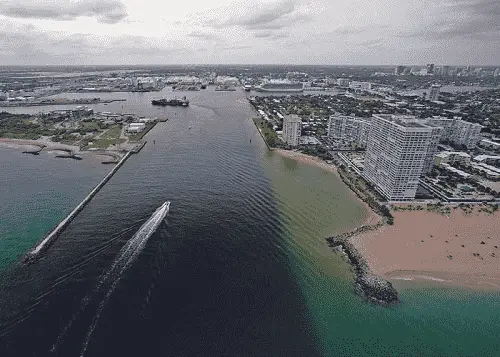
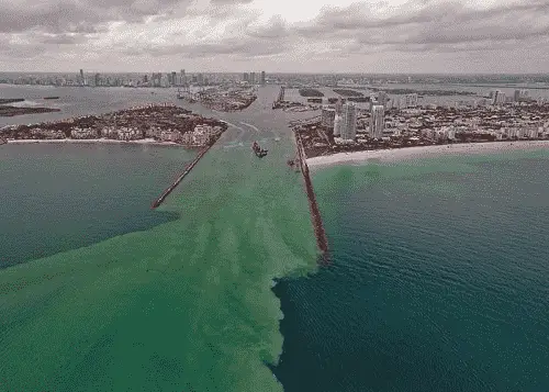
Government Cut
Government Cut (The Port of Miami) is a deepwater port located 19.4 NM south of Ft. Lauderdale (Port Everglades) and 10.7 NM north of Fowey Rocks Light. It provides access to Miami, Miami Beach, and Virginia Key, FL as well as the AICW.
The approach is marked by a lighted buoy (RW “M” Mo(A) RACON (--) AIS) 2.6 NM ENE of the entrance located at 25°46’06" N / 080°05’00" W. The approach is deep 50+ feet and well-marked by lighted buoys and ranges.
Prominent on the approach is the tall green and black building at about 25°47’26" N / 80°07’56" W, on which red obstruction lights and an illuminated time and temperature sign, flashing from 0700 to 2359, can be seen from over 16 NM offshore. A tall stack and water tank on Virginia Key, Cape Florida Light (Fl 6s 95ft Priv), and the aeronautical light at Miami International Airport (Rot W&G).
Radar targets on the approaches to Miami are poor, except for the land and jetty configurations. Heavy small-craft traffic in the vicinity of the sea buoy and entrance buoys may make visual or radar identification of these buoys difficult. In making a night approach, the many lights on Miami Beach may make identification of navigational aids difficult.
The dredged entrance is protected by (2) unmarked jetties. It is deep 40+ feet and well-marked by lighted buoys, beacons, and a lighted range. Mariners are advised that abrupt shoaling may be encountered along the northerly and southerly edges of the dredged channel.
The Atlantic Intracoastal Waterway can be intersected 3.7 NM above the entrance at (MM "1089.0") near lighted beacon Fl R 2.5s "50" showing a white sector on entering.
Cautions - A shoal marginal area about 100 feet wide extends between the northern edge of the channel and the MacArthur Causeway along almost its entire length.
A Precautionary Area has been established with a radius of one nautical mile around the sea buoy. All vessels are to exercise extreme caution within this area. Vessels may not anchor within those portions of the Precautionary Area that lie outside the designated anchorage areas.
A fishing pier, marked by a light at each end, is on the south side of the inshore end of the north jetty. The lights are reported to be difficult to distinguish.
Caution should be exercised when entering Government Cut from the sea during flood tide with northeasterly winds; a strong turning torque occurs when the bow is just inside the north jetty. A similar but less serious situation occurs when leaving the port during ebb tide. Horizontal current gradients that may make maneuvering difficult occur in the turning basin north of Fisher Island.
Tides and Currents - Mean tidal range is 2.4 feet at the entrance. Strong tidal currents run in the entrance between the jetties; the current velocity being about 2 to 4 knots. A northerly wind causes a considerable southerly set across the ends of the jetties. Vessels are advised to favor the southerly side of the entrance channel during southerly winds, as a pronounced northerly set may be experienced.
Dangers - Shoals extend about a mile offshore northward of the entrance, and vessels approaching from the northward should keep at least 1.5 miles offshore until within 4 miles of the entrance and then haul out for the sea buoy.
The outer reefs, for about 10 miles south of the entrance, are unmarked except for the northerly red sector in Fowey Rocks Light, and vessels approaching from that direction should stay outside this sector until well up before closing the sea buoy.