Entrances, Inlets, & Passes - Florida’s West Coast
Florida’s West Coast Entrances, Inlets, & Passes
Whether you are making use of the Gulf Intracoastal Waterway or sailing coastwise along Florida’s West Coast, There are numerous Entrances, Inlets, or Passes between the deep waters of the Gulf of Mexico and the West Coast of Florida. Between Sanibel Island and San Carlos Bay Entrance in the south north to Port Richey, there were 23 at last count in January 2020. Most all provide access to sheltered inland waters and providing access to the Gulf Intracoastal Waterway.
While many of these are only suitable for shallow draft vessels and/or local knowledge, some can be considered navigable for most vessels. We have listed them below along with useful information on each to aid you in deciding if you wish to use a particular inlet.
Entrances, Inlets, and Passes
San Carlos Bay Entrance
Found between Sanibel Island to the west and Estero Island to the east, this is the principal entrance from the Gulf of Mexico for Fort Myers Beach, the Caloosahatchee River, Sanibel, the GICW, the Okeechobee Waterway, Cape Coral, and Ft. Myers, FL.
The Gulf Intracoastal Waterway and the Okeechobee Waterway can be intersected 4.0 NM above the entrance near lighted beacon (Q G 16ft 4M "101") at (GICW MM "0.0") or Okeechobee Waterway (MM "156.4").
Approach
The approach is marked by San Carlos Bay Light ("SC" Mo (A)), located 2.8 NM SSE of the entrance and 3.6 NM SE of Pt. Ybel at (26°25’08"N / 81°57’33"W). The approach channel is well-marked by charted lighted beacons with charted depths of 9 to 15 feet mid-channel.
Prominent on the approach from seaward is Sanibel Island Light (Fl (2) 6s 98ft 13M) at
(26°27’11"N / 82°00’51"W). Standing 98 feet above the water. It is shown from a 102 foot brown square pyramidal skeleton tower enclosing a stair cylinder on Point Ybel at the SE tip of Sanibel Island.
Entrance
The main entrance channel proceeds in a general northerly direction where it intersects the GICW and the OWW approximately 1.8 NM above the Sanibel Causeway "A" Span Bridge. It then turns more easterly leading to Cape Coral and Fort Myers. You can also elect to continue on eastbound on the Okeechobee Waterway until reaching the East Coast of Florida.
The secondary channel takes you just inside of Sanibel Island in a generally north-westerly direction until intersecting with the Gulf Intracoastal Waterway at (MM "3.3") in upper San Carlos Bay. Lighted and unlighted buoys and beacons mark the limits of the natural channel.
The secondary channel is restricted by Sanibel Causeway Bridge "C" Span Bridge with a vertical clearance of 26 feet.
Cautions
A shoal 0.5 NM west of the approach channel is covered 1 to 5 feet. Upper San Carlos Bay’s is largely filled with shoals on which the depths vary between bare and 5 feet. The bay and adjacent waters are frequented mostly by small vessels and yachts.
Tides & Currents
The mean tidal range is 1.8 feet at Sanibel Island Light and about the same in Pine Island Sound. The average velocity of the current is 1.0 knot in San Carlos Bay off Point Ybel.
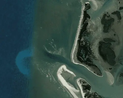
Blind Pass
Located between Captiva Island to the north and Sanibel Island to the south, Blind Pass lies about 12.6 NM WNW from San Carlos Bay approach beacon. It provides access to the southern end of Pine Island Sound, St. James City, FL and the GICW.
The Gulf Intracoastal Waterway can be intersected 2.4 NM above the entrance near lighted beacon (Q R 16ft 4M "26") at (MM "9.2").
Approach
The approach is unmarked over a constantly shifting bar covered 3 feet.
Entrance
The entrance is marked by private uncharted unlighted beacons and is subject to frequent changes.
Cautions
The continually shifting shoals and lack of navigation marks make the use of this pass hazardous. This pass is not recommended for other than shallow draft vessels with local knowledge. A highway bridge over the pass has a 38-foot fixed span with a vertical clearance of 7 feet.
Tides & Currents
The mean tidal range is around 1.6 feet.
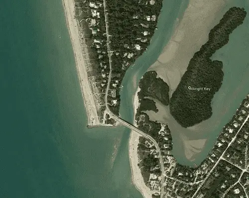
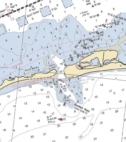
Redfish Pass
Redfish Pass, found 4.3 NM NNW of Blind Pass, provides a passage between North Captiva Island to the north and Captiva Island to the south from the Gulf of Mexico. It provides access to Pine Island Sound and the GICW.
The Gulf Intracoastal Waterway can be intersected 2.4 NM above the entrance near lighted beacon (Fl G 4s 16ft 4M "39") at (MM "13.7") in Pine Island Sound.
Approach
The approach is marked by a buoy (G "1" Fl G 2.5s) about 0.8 NM west of the entrance. This buoy as well as all approach channel buoys are privately maintained. The approach is over a shifting bar covered 0.5 to 5 feet. Once over the bar the depths increase to 9 to 19 feet until inside the entrance.
Entrance
The entrance channel is winding and difficult. It is marked by private buoys and daybeacons with strong currents and frequent changes in depth and position.
Cautions
A partially submerged groin is on the south side of the pass. This pass should not be attempted without local knowledge.
Tides & Currents
The mean tidal range is around 1.4 feet.
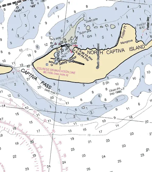
Captiva Pass
Captiva Pass located about 3.5 NM north of Redfish Pass between North Captiva Island and Cayo Costa. It leads in from the Gulf of Mexico providing access to the upper portion of Pine Island Sound and the GICW. It is used to some extent by small fishing vessels.
The Gulf Intracoastal Waterway can be intersected 1.3 NM above the entrance at approximately (MM "18.8") near lighted beacon (Fl G 4s 16ft 5M "51").
Approach
The approach is unmarked and is mostly obstructed by a bar covered 0.5 to 6 feet. The approach channel is likewise unmarked with depths of 7 to 27 feet.
Entrance
The entrance is unmarked and subject to change with depths of 19 to 42 feet rapidly lessening to 10 to 19 feet.
Cautions
The approach and entrance channels are unmarked and subject to change. Local knowledge is required to carry the best water. In 1988 a visible wreck was reported in the entrance channel in about 26°35’00" N / 82°13’30" W.
Tides & Currents
The mean tidal range is around 1.1 feet.
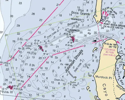
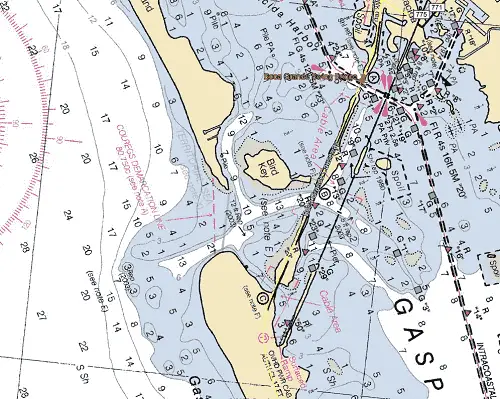
Boca Grande Pass/Charlotte Harbor Inlet
Located 26.5 NM SSE of Venice Inlet, Charlotte Harbor Inlet separates Gasparilla Island to the north and Cayo Costa to the south. It is the principal inlet to Punta Gorda, Port Charlotte, and the Peace River.
The Gulf Intracoastal Waterway can be intersected 0.9 NM above the entrance at approximately (MM "26.1") north of lighted beacon (Fl R 2.5s 15ft 5M "76").
Approach
The approach is marked by a pair of lighted buoys (G “1” Fl G 2.5s) and (R “2” Fl R 2.5s) located 3.8 NM southwest of the entrance. Vessels should make their approach through the Charlotte Harbor Safety Fairway.
The approach channel is well marked by lighted and unlighted buoys with a project depth of 32 feet to Port Boca Grande. Shoals line both sides of the approach covered 3 to 6 feet.
Prominent on the approach is Port Boca Grande Light (Oc 4s 41ft 12M at (26°43’02" N / 82°15’39" W), standing 41 feet above the water, shown from a white frame dwelling on the south end of the island.
Entrance
The entrance is unmarked, but wide with good water almost bank to bank with depths of 31 to 69 feet to just inside the entrance.
A break in the shoal on the north side of the channel near the south end of Gasparilla Island forms a swash channel which was reported to have a controlling depth of 8 feet in 1982. The best water in this swash channel is about 150 yards off the point, using the end of the fishing pier as a guide.
Once inside the inlet, a natural channel, marked by lighted and unlighted beacons, leads from Port Boca Grande to the Gulf Intracoastal Waterway in Charlotte Harbor. From this point to the upper harbor and the mouth of the Peace River a controlling depth of 9 feet will be found.
Cautions
Numerous floating piles have been reported in Charlotte Harbor and adjacent waterways and in Boca Grande Channel and its approaches.
Any deviation from the marked approach channel should only be attempted with local knowledge as this area is subject to continual change.
Shoals with depths of 2 to 5 feet border the approach channel.
Tides & Currents
The mean tidal range is 0.9 feet at the entrance. The tidal currents in the entrance channel average 2.2 knots at strength. The ebb current is said to attain an extreme velocity of 3 to 4 knots, depending upon the force and direction of the wind.
In the harbor channel between Cape Haze and the north end of Pine Island the average velocity of the current is 0.5 knot.
Gasparilla Pass
Gasparilla Pass located 6.3 NM north of Boca Grande Pass and 20.5 NM SSE of Venice Inlet. It separates Gasparilla Island to the south and Little Gasparilla Island to the north. It affords an entrance from the Gulf of Mexico into Gasparilla Sound, Placida Harbor, and the GICW.
The Gulf Intracoastal Waterway can be intersected 1.3 NM above the entrance at approximately (MM "34.2") just east of the Boca Grande Swing Bridge.
Approach
The approach is unmarked and obstructed by a bar covered 1 to 5 feet. In 2003, the reported controlling depth over the bar through the unmarked channel was 3.5 feet.
Entrance
Once over the bar, the entrance is deep with depths of 13 to 21 feet. Like the Approach, it is unmarked.
Cautions
Local knowledge is needed to carry the deepest water. A fixed bridge with a clearance of 26 feet, 0.6 NM above the entrance, restricts access. Hydrography and the shorelines are subject to continual change with shifting shoals.
Tides & Currents
Mean tidal range is about 1.1 feet with an average current velocity of 1.0 knots on the flood and 1.1 knots on the ebb.
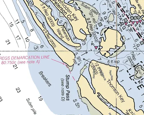
Stump Pass
Stump Pass, 6 NM NNW of Gasparilla Pass and 14.7 NM SSE of Venice Inlet, located between Knight Island and Manasota Key. Stump Pass affords passage from the Gulf of Mexico into the south end of Lemon Bay and the GICW.
The Gulf Intracoastal Waterway can be intersected 0.9 NM above the entrance at approximately (MM "41.0") near unlighted beacon (G "17A").
Approach
The approach is marked by a private light with a daymark reading “Danger Navigate with Local Knowledge Only.” The approach channel is subject to frequent change in depths and location and should not be attempted without local knowledge.
Entrance
Likewise, the entrance channel is subject to frequent change and should not be attempted without local knowledge.
Cautions
The natural channel location through Stump Pass is subject to continuous change in alignment and depth. Do Not Navigate in or through the area without absolute knowledge of the channel location and depth. Hydrography and the shorelines are subject to continual change with shifting shoals.
Tides & Currents
The mean tidal range is about 1.2 feet.
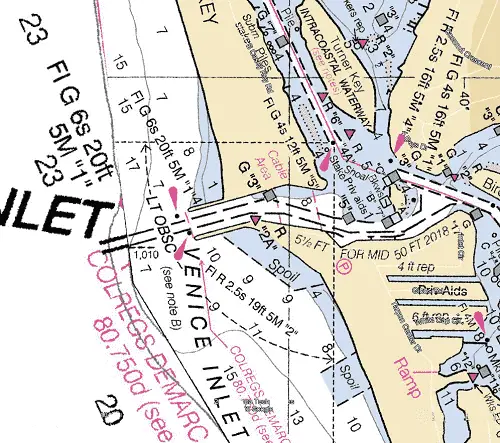
Venice Inlet
Venice Inlet is found 26 NM northwest of Port Boca Grande and 10.1 NM SSE of Big Sarasota Pass. It separates Casey Key to the north with what the locals refer to as Venice Island to the south. It affords a passage from the Gulf of Mexico to the GICW, Roberts, Dona and Lyons Bays as well as Venice, FL.
The Gulf Intracoastal Waterway can be intersected 0.5 NM above the entrance at (MM "58.5") near Bird Island.
Approach
The approach is unmarked with an uncharted marked dredged channel leading east from the Gulf of Mexico over the bar covered 7 to 9 feet.
Entrance
The entrance is marked by Venice Inlet Light (FL G 6s 20ft 5M "1" and Fl R 2.5s 19ft 5M "2" lying close to (27°06’46" N / 82°28’13" W) just off the outer end of parallel jetties. The inlet is a dredged channel, with a reported depth of 7.8 feet mid-channel. Unlighted beacons mark the channel.
Cautions
An unmarked fish haven is about 1 mile southwest of Venice Inlet covered 12.5 feet.
Tides & Currents
The Tidal Range is 1.3 feet and the tidal currents in the entrance channel average 1.1 knots on the flood and 0.9 knots on the ebb.
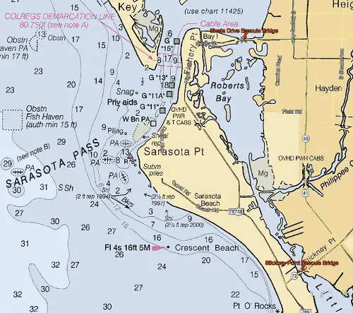
Big Sarasota Pass
Big Sarasota Pass located 12 miles NNW from Venice Inlet and 21 NM SSE of Tampa Bay Entrance. It leads from the Gulf of Mexico between Siesta Key to the south and Lido Key to the north into the southern portion of Sarasota Bay affording access to the GICW and Sarasota, FL.
The Gulf Intracoastal Waterway can be intersected approximately 1.6 NM above the entrance at MM "73.2" near lighted beacon (Fl R 4s 16ft 5M “8”).
Approach
The approach is marked by a lighted beacon (Fl 4s 16ft 5M) lying 2.3 NM south of the entrance. The approach channel over the bar is reported to be marked by uncharted private buoys. The bar has many wrecks with depths of 2 to 5 feet reported and is subject to continual change. Once over the bar depths in the approach channel range from 7 to 26 feet.
Prominent on the approach are several large hotel buildings at the south end of Lido Key and along the shore of Siesta Key.
Entrance
The entrance channel is deep with depths of 9 to 19 feet and marked by unlighted private beacons. Once inside the pass, the channel is well marked with unlighted private beacons.
Cautions
Shoals exist on the northern side of the pass. Breakers often occur to the west of the approach channel. The approach channel over the bar is subject to continual change. Mariners are advised to exercise extreme caution.
Tides & Currents
The mean tidal range in the vicinity of Big Sarasota Pass averages about 1.3 feet, the same as Venice Inlet. The flood current sets north with an average velocity of 1.5 knots, and the ebb sets south with an average velocity of 1 knot.
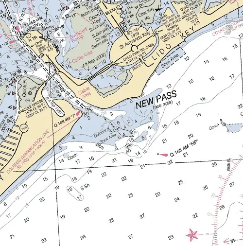
New Pass
Found 2.7 NM NNW from Big Sarasota Pass, New Pass enters between Lido Key to the south and Longboat Key to the north. It affords a passage from the Gulf of Mexico to the southern end Sarasota Bay, the GICW and Sarasota, FL.
The Gulf Intracoastal Waterway can be intersected approximately 1.7 NM above the entrance at MM "74.5" near unlighted beacon (RG "NP").
Approach
The approach is marked by a lighted beacon (Q 16ft 4M "NP") found 0.9 NM west of the entrance near (27°18’55" N / 82°35’53" W). The approach channel is over a bar covered 0.5 to 5 feet and is marked by uncharted buoys.
Entrance
It has a marked and dredged channel with the buoys not charted as they are frequently shifted in position to mark the best water. A controlling depth of 7 feet from lighted beacon (Q 16ft 4M "7") to the bascule bridge (23 feet closed), crossing the eastern end of the pass. From there 4 feet to the intersection with the GICW.
Cautions
A number of charted wrecks dangerous to surface navigation are on the bar. The approach and entrance channels are subject to shoaling and continual change.
Tides & Currents
The mean tidal range at New Pass is approximately 1.4 feet. The flood current sets northeast with an average velocity of 1.6 knots, and the ebb sets southwest with an average velocity of 1 knot.
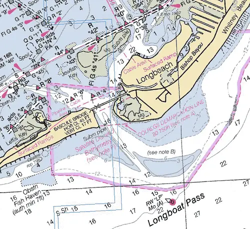
Longboat Pass
Longboat Pass is found 18.9 NM southeast of the Tampa Bay Approach Buoy. It affords passage from the Gulf of Mexico to the north end of Sarasota Bay and the GICW between Longboat Key to the south and Anna Maria Island to the north.
The Gulf Intracoastal Waterway can be intersected approximately 0.9 NM above the entrance at MM "86.0" near lighted beacon (Fl G 2.5s 5M "47").
Approach
The approach is marked by lighted buoy (RW “LP” Mo(A)) 0.8 NM SW of the entrance at (27°26’06" N / 82°42’10" W).
The approach channel is marked by uncharted buoys with depths of 12 to 16 feet mid-channel. Greater depths may be available with local knowledge.
Entrance
A channel with a controlling depth of 9 feet and charted depths of 16 feet, to the bascule bridge (17 feet) is marked by uncharted buoys. Greater depths may be available with local knowledge.
Cautions
The charted approach and entrance depths are derived from satellite imagery from 2014-2015. Their vertical accuracy is typically ± 7 feet. Uncharted dangers may exist within this area.
Shoaling covered 3 to 6 feet extends west and south in an arc from the south end of Anna Maria Island and also west from the northwest end of Longboat Key.
The channel is subject to continual changes at the entrance.
Tides & Currents
The mean tidal range in Longboat Pass averages 1.5’. The flood current sets east with an average velocity of 1.8 knots, and ebb sets west with an average velocity of 1.6 knots.
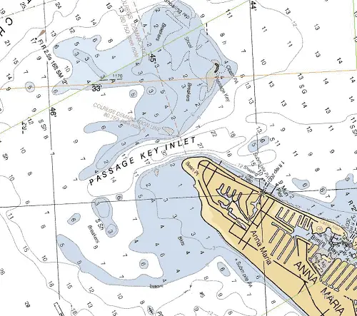
Passage Key Inlet
Passage Key Inlet is located just off the northern tip of Anna Maria Island and south of Passage Key, 6.8 NM NNW of Longboat Pass. It provides access to the southeastern portion of Tampa Bay, The Manatee River, and the GICW. It is used only by small local craft.
The Gulf Intracoastal Waterway can be intersected about 3.0 NM above the entrance at (MM "93.9") if you are northbound. If southbound, 2.5 NM above the entrance at (MM "92.6").
Approach
The approach and approach channel are constantly shifting and are unmarked with depths of 7 to 32 feet mid-channel. Shoals exist on both sides of the approach.
Entrance
The entrance is deep with charted depths of 22 to 32 feet mid-channel. Shoals exist on both sides of the entrance.
Cautions
The shifting channels of Passage Key Inlet are not recommended without local knowledge. Shoals with depths of bare to 3 feet are found on either side of the approach and entrance. Breakers often occur southward of the approach channel.
Tides & Currents
The mean tidal range in Passage Key Inlet averages 1.5 feet. The flood current sets east with an average velocity of 0.9 knots, and ebb sets west with an average velocity of 1.1 knots.
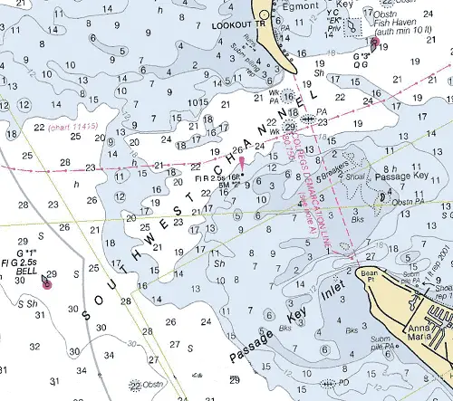
Southwest Channel
Southwest Channel, a natural passage lying immediately south of Egmont Key, 2.3 NM south of Tampa Bay Entrance. It affords access to Tampa Bay, the GICW, St. Petersburgh, and Tampa, FL.
The Gulf Intracoastal Waterway can be intersected about 5.3 NM ENE above the entrance at (MM "97.5") if you are northbound. If southbound, 3.4 NM ESE above the entrance at (MM "91.1").
Approach
The approach is marked by a lighted bell buoy (G "1" Fl G 2.5s BELL) located 3.9 NM SW of Egmont Key at (27°32’20" N / 82°48’36" W). The approach channel is obstructed by a bar covered 11 to 18 feet and is marked by a single lighted beacon (Fl R 2.5s 15ft 5M "2").
Prominent on the approach is Egmont Key Light (Fl 15s 85ft 13M) lying 2.4 NM north of the entrance at (27°36’03" N / 82°45’38" W) and should be visible well offshore.
Entrance
The entrance channel itself is marked by a lighted beacon (Fl R 2.5s 16ft 5M "2") on the seaward side and a lighted bell buoy (G "3" QG) on the bay side. The channel has a controlling depth of about 14 feet and charted depths of 15 to 29 feet, but is subject to shoaling.
Cautions
Breakers often occur southward of the entrance near Passage Key. Three sunken wrecks are located in the entrance. (2) Are covered 16 feet or more with (1) possibly causing a danger to surface navigation.
Tides & Currents
The mean tidal range in Southwest Channel averages 1.5 feet. The flood current sets east with an average velocity of 0.9 knots, and ebb sets west with an average velocity of 1.1 knots.
Tampa Bay Entrance
From Mullet Key to the north to Anna Maria Island to the south, the entire entrance into Tampa Bay is 4.4 NM wide. Unfortunately, with the exception of a (3) channels, the majority of the entrance is obstructed by Keys, shoals, and shallow water. Tampa’s main shipping channel (Egmont Channel) provides deep draft and well-marked access into Tampa Bay. Egmont Channel affords access to Bradenton, Port Manatee, Teco Big Bend, Alafia River, Tampa, Port Tampa, St. Petersburgh, FL, and the GICW.
Using the Egmont Channel Entrance, the Gulf Intracoastal Waterway will be intercepted 4.4 NM above the entrance at MM "97.9" at lighted buoy (R "26" Q R); approximately 0.8 NM below the Sunshine Skyway Bridge (180 feet).
Approach
The approach is marked by Tampa Bay Lighted Buoy (RW “T” Mo(A)) equipped with AIS and RACON (▬) located 13.5 NM west of Egmont Key at (27°35’19" N / 83°00’42" W).
The approach channel is deep and well-marked with lighted buoys and project depths of 45 feet until the entrance. A high intensity lighted range showing white lights during the day and green at night is also shown.
Prominent on the approach is Egmont Key located on the south side if the entrance and Egmont Key Light (Fl 15s 85ft 13M) on the south side of the entrance at (27°36’03" N / 82°45’38" W), shown from a white tower. A pilot station lookout tower near the center of the island and nearby buildings are conspicuous.
Old Fort DeSoto on the south end of Mullet Key and a tall water tank on St. Jean Key about 1.5 miles northeast of the fort stand out at the head of Egmont Channel.
Also prominent to the north are the numerous tall hotel and apartment buildings and a church spire, a tall building on Maximo Point and farther north other numerous tanks and buildings along the beaches and at St. Petersburg and Gulfport.
Vessels should make their initial approach approach through the Tampa Safety Fairway.
Entrance
The entrance is likewise well-marked and deep with lighted buoys and a project depth of 45 feet until turning on to Mullet Key Channel. Once above the entrance, the main shipping channel is marked by lighted buoys and shows range lights to the head of the bay.
Cautions
Shoals and obstructions extending out 5.8 NM line the approach and entrance channel covered 2 to 16 feet. Heavy commercial traffic can be expected.
Tides & Currents
The mean tidal range in Tampa Bay is about 1.5 feet. A strong offshore wind sometimes lowers the water surface at Tampa and in the dredged channels as much as 4 feet. A continued SW wind raises the water by nearly an equal amount.
There is a large daily inequality in the ebb currents. Velocities of 2 knots or more may be expected at the greater ebb of the day in Egmont Channel, Passage Key Inlet, and off Port Tampa. Flood velocities seldom exceed 2 knots.
Crossing Tampa Bay on the GICW
From Anna Maria Island, The Gulf Intracoastal Waterway continues north-northeast across the lower portion of Tampa Bay where it intersects the main shipping channel at mile marker "97.9" in the vicinity of lighted buoy ( R "26" Q R).
If continuing north on the GICW, a choice can be made of routes taken upon reaching the main shipping channel; depending on your draft requirements.
Route #1 (GICW Route) turns to the northeast following the main shipping channel to mile marker "102.9" lighted buoy (R "6B" Fl R 2.5s). Your course will then change to the north until reaching lighted beacon (Q G 16ft 3M "3") where you will turn to the west.
Route #2 (Sunshine Skyway Channel) has you continuing northward from the main shipping channel until intersecting the Sunshine Skyway Channel (SSC) at lighted beacon (Fl G 4s 16ft 5M "1"). You will then continue along the SSC for approximately 4.3 SM where you will once again turn to the west joining the GICW at (MM "110.8") near lighted beacon (Fl G 4s 15ft 5M "15"). While the SSC will shave almost 7 miles off of your trip northbound, be cautioned, reports of shoaling to 5 feet have been reported in the Sunshine Skyway Channel.
Bunces Pass
Located 3 NM north of Tampa Bay’s main entrance, Bunces Pass provides a passage between the north end of Mullet Key and the south end of Cabbage Key, into the southern part of Boca Ciega Bay, the GICW, and Tampa Bay.
Access to the Gulf Intracoastal Waterway is via the Sunshine Skyway Channel (3.5 NM above the entrance), if northbound you can intercept the GICW at MM "110.8," if southbound you can intercept at MM "98.0" just south of the Sunshine Skyway Bridge.
Approach
The approach is unmarked and completely obstructed by a shifting bar covered 1 to 6 feet and extending out 1.0 NM from the entrance. Greater depths can be found once over the bar.
Entrance
The entrance is marked with unlighted beacons and has depths of 8 to 22 feet to where it intersects the GICW.
Cautions
In addition to the shoals, the passage has a fixed bridge spanning the channel with a vertical clearance of 20’ approximately 1.7 NM above the entrance. 2 partially submerged wrecks lie on the approach west of the entrance. Local knowledge is necessary to use the pass.
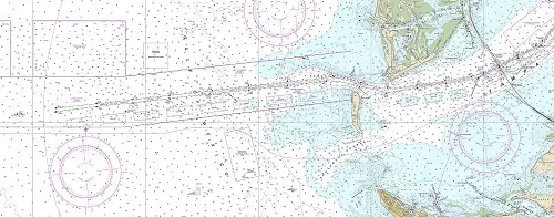
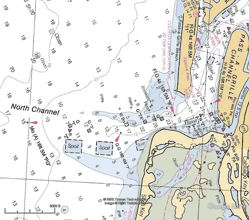
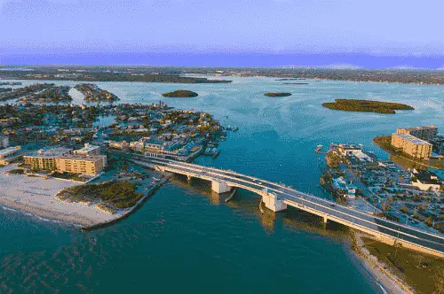
North Channel/Pass-A-Grille
North Channel, often referred to as Pass-a-Grille Channel, lies immediately south of Long Key and north of Shell Key, about 4.4 NM north of the Tampa Bay Entrance. It affords access to the GICW, Gulfport, St. Petersburg Beach, and St. Petersburgh, FL.
After entering, the Gulf Intracoastal Waterway can be intersected 1.6 NM above the entrance near lighted beacon (Q R 16ft 4M "24") at (MM "113.6").
Approach
The approach to North Channel is marked by a lighted beacon (Mo (A) 16ft 5M "PG") lying about 1.5 NM west of the entrance at 27°40’35"N / 82°46’01"W.
From the outermost channel markers, the approach channel passes through the bar and connects immediately with Pass-a-Grille Channel at the entrance. Depths of 8 to 28 feet are found mid-channel in the approach. It is well marked by lighted and unlighted beacons.
Entrance
The entrance is well marked with lighted and unlighted beacons. In 2009, the controlling depth in North Channel was 4.6 feet (7.5 feet at mid-channel) to the main channel of the Intracoastal Waterway. Charted depths of 12 to 22 feet are shown in the entrance.
Cautions
A shoal covered 1 to 6 feet lines the north side of the approach channel.
Tides & Currents
The mean tidal range at the entrance averages around 1.5 feet. In Pass-a-Grille Channel, the flood current sets north with an average velocity of 1.2 knots and the ebb current sets south with an average velocity of 1.4 knots.
Blind Pass
Found about 3.7 NM north of North Channel Pass, Blind Pass is shallow, leading from the Gulf of Mexico to Boca Ciega Bay between the north end of Long Key and Treasure Island. The approach and entrance are unmarked with charted depths of 2 to 6 feet. The pass is used by local fishing boats and other small craft. A highway bridge crossing the pass near the inner end has a vertical clearance of 11 feet effectively blocking access to the GICW for most vessels. Blind Pass channel is unimproved, unmarked, and local knowledge is required.
Johns Pass
Johns Pass located about 3 miles north of Blind Pass, between Treasure Island and Sand Key, affords passage to the north part of Boca Ciega Bay. A marked channel leads from the Gulf of Mexico through Johns Pass thence north to the GICW.
The Gulf Intracoastal Waterway can be intersected 1.3 NM above the entrance near daybeacon (Fl R 4s 12ft 5M "4") at (MM "121.5").
Approach
The approach is marked by a lighted beacon (Mo (A) 16ft 6M "JP") located 1.1 NM WSW of the entrance at 27°46’30"N / 82°48’01"W. The approach is through a dredged channel with charted depths of 8+ feet mid-channel. It is marked by unlighted buoys and lighted and unlighted beacons. A shoal exists to the NNW of the approach channel covered 1 to 2 feet.
Entrance
The entrance is protected by a groin to the southwest marked on its end by a lighted beacon (Fl 6s 13ft 5M Priv). A Bascule Bridge (28 feet) crosses the entrance.
Cautions
Considerable shoaling between Daybeacon 1 and Buoy 3. Extreme caution and local knowledge of the channel conditions is advised.
Tides & Currents
Tidal range for Johns Pass averages 1.5 feet. The flood current sets northeast at an average velocity of 2.0 knots and ebbs southwest at an average velocity of 1.5 knots.
Clearwater Pass
Clearwater Pass located 12 NM north of Johns Pass, leads in from the Gulf of Mexico between the north end of Sand Key and the south end of Clearwater Beach Island. It provides access to Clearwater Beach Island, the GICW, and Clearwater, FL.
The Gulf Intracoastal Waterway can be intersected 0.8 NM above the entrance near daybeacon (Fl R 4s 16ft 4M "12") at (MM "135.4").
Approach
The approach to the pass is marked by a lighted beacon (Fl G 2.5s 18ft 3M "1" at 27°58’16"N / 82°50’51"W) lying about 0.7 NM west of the entrance. A dredged channel leads in to the entrance. It is well-marked with lighted and unlighted beacons and has a controlling depth of 9.5 feet.
Prominent on the approach is a large white apartment hotel near the north end of Clearwater Beach Island, a large hotel on the island on the north side of the Clearwater Memorial Causeway, several tall radio towers and several other prominent buildings. At Dunedin, 3 miles north of Clearwater, a large hotel, two tanks and a stack are conspicuous.
Entrance
The pass is a dredged channel over the bar. It is well marked with lighted and unlighted beacons with a controlling depth of 8.5 feet on the channel’s centerline from the Gulf t the fixed bridge (clearance 74 feet) at the head of the pass. More than 7 feet is then available until intersecting the Gulf Intracoastal Waterway at MM "135.5" about 1.5 NM above the pass.
Cautions
Shoaling to less than 3 feet is found on both the north and south side of the dredged approach and entrance channels.
Tides & Currents
The mean tidal range at Clearwater is 1.8 feet with the tidal current in Clearwater Pass averaging about 1.2 knots.
Dunedin Pass
Dunedin Pass, 3 miles north of Clearwater Pass at the opposite end of Clearwater Beach Island, is marked by private daybeacons. In 1984, the pass was reported shoaled to 1 foot and closed to navigation.
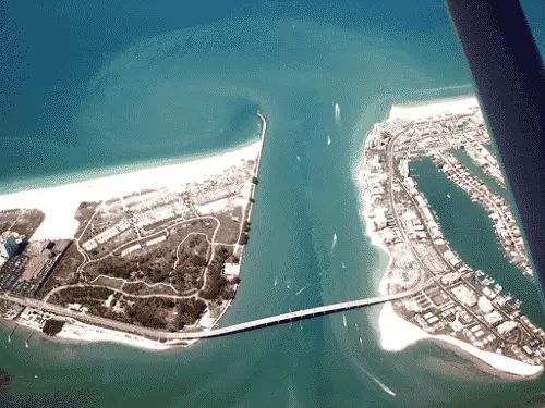
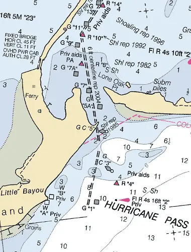
Hurricane Pass
Hurricane Pass, between Caladesi Island and Honeymoon Island. The pass is very dynamic and subject to change. It affords access to the GICW, Dunedin, and Palm Harbor, FL.
The Gulf Intracoastal Waterway can be intersected 1.5 NM above the entrance near daybeacon (R "18") at (MM "141.7").
Approach
The approach is marked by a lighted beacon (Fl R 4s 16ft "2") 28°03’ 08"N / 82°49’53"W). Unlighted buoys and beacons mark the approach channel.
Entrance
The entrance channel is bordered on all sides by shoals covered 2 feet but is well marked with private unlighted day beacons. 6 feet of water mid channel was reported in 2004.
Dangers – The area west and north of Honeymoon Island was reportedly shoaled to bare and passage between Honeymoon Island and Three Rooker Bar to the north should only be made with caution.
The mean tidal range at Dunedin and St. Joseph Sound is 1.9 feet.
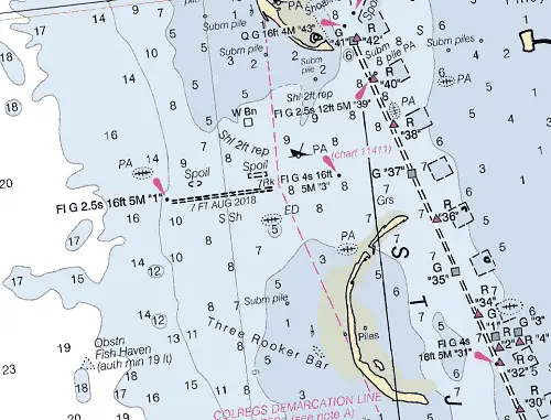
Anclote Key Pass
Found between the north end of Three Rooker Bar to the south and Anclote Key to the north provides access from the Gulf of Mexico to St. Joseph Sound, the Anclote River, and Tarpon Springs, FL.
The Gulf Intracoastal Waterway can be intersected 1.1 NM above the entrance near daybeacon (G "37") at (MM "147.8").
Approach
The approach is a combination of a natural and dredged channel with depths of 7 to 12 feet. The approach end is marked with a lighted beacon (Fl G 2.5s 16ft 5M "1" at 28°08’30"N / 82°51’59"W), about 1 NM west the pass.
A minimum depth of 8 feet has been reported until it intersects the Gulf Intracoastal Waterway at MM "148.5" a little more than 1 NM above the entrance. There are no other buoys or beacon until inside of the entrance.
Prominent on the approach is a private light (Fl (4) 30s 110ft) shown from the southern end of Anclote Key.
Entrance
The entrance channel is marked by a single lighted beacon (Fl G 4s 16ft 5M “3”). It is reported that a minimum of 8 feet of water is in the entrance until the intersection with the GICW.
Cautions
A partially sunken wreck located about half way through the pass; easily seen and avoided.
Tides & Currents
The mean tidal range is 2.6 feet in the entrance. Just eastward of the south end of Anclote Key, the tidal current has an average velocity of 0.6 knot on the flood and 0.8 knot on the ebb.
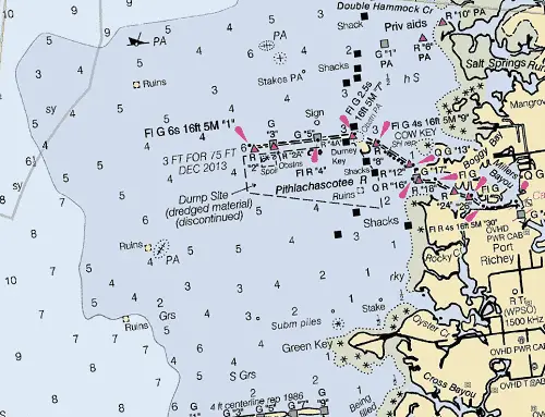
Port Richey Entrance
Port Richey Entrance lies just north of Anclote Key and to the west of Port Richey; approximately 5.2 miles north of the GICW. It has a wide open approach with depths of 7 to 12 feet on the approach from deep water.
The approach is obstructed by an extensive shoal covered 4 to 8 feet. The approach channel, marked by lighted beacon (Fl G 6s 16ft 5M "1") at 28°17’08"N / 82°46’15"W), is a dredged channel and marked by lighted and unlighted beacons. The approach channel is reported to have a controlling depth of 3 feet in 2013.
Entrance
The entrance is shallow but well-marked by lighted and unlighted beacons to Millers Bayou. Depths of 2 feet and greater can be carried to New Port Richey with local knowledge.
Cautions
Shoals surround the approach with charted depths of 1 to 3 feet.