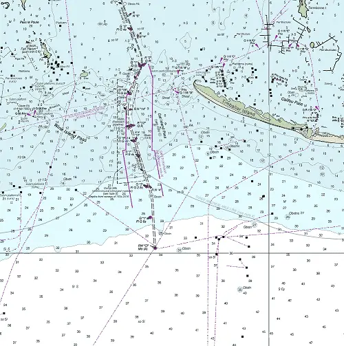
Chef Menteur Pass
Chef Menteur Pass, located 10.3 NM southwest of Rigolets Inlet. Provides access to the GIWW and Lake Pontchartrain.
NOAA Chart #11371 - Lake Borgne and Approaches is suggested for the approach to Chef Mentuer Pass while NOAA Chart #11367 - Waveland to Catahoula Bay is suggested for the entrance.
The Gulf Intracoastal Waterway is found 1.5 NM above the entrance at (MM "22.9 EHL") near lighted beacon (Fl R 2.5s 17ft 4M "4").
Approach
The approach is marked by a lighted beacon (Fl R 4s 17ft 5M "2"). The approach is surrounded by shoals, but 6 feet can be carried with careful navigation and 5 feet can be carried over the shoals at most times.
Entrance
The entrance and pass is unmarked with reportedly good water bank to bank. Charted depths increase to 30+ feet mid-channel until reaching the Gulf Intracoastal Waterway.
Cautions
A new Gulf Intracoastal Waterway alignment channel crosses Chef Menteur Pass 1 mile SSE of the original Intracoastal Waterway crossing, but reports are of shoaling to 3 feet. Caution is advised.
Tides & Currents
The mean tidal range is approximately 1.4 feet.
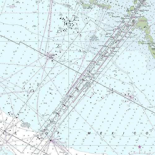
Southwest Pass
Southwest Pass, the westernmost of the passes for the Mississippi River and the only one capable of deep draft vessels. Making use of the Mississippi River, the majority of the mid-west is accessible through this pass. From New Orleans, LA to the head of navigation in Minneapolis, MN and entrance to the Great Lakes via Chicago, IL.
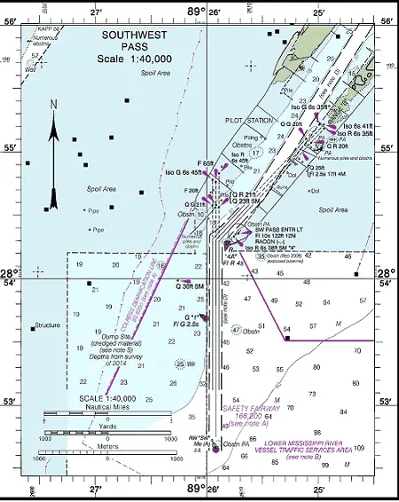
NOAA Chart #11361 - Mississippi River Delta is suggested for the approach to Southwest Pass while the “Southwest Pass Inset” on the above chart can be used for the entrance.
Intersection with the Gulf Intracoastal Waterway happens at a number of locations off the Mississippi River depending upon whether you are eastbound or westbound beginning about 97.8 NM above the Southwest Pass Entrance.
Approach
The approach to Southwest Pass is marked by buoy (RW "SW" Mo (A) located at 28°52’39"N / 89°25’55"W), approximately 1.75 NM south of the entrance. Lighted buoys and ranges mark the approach.
Prominent on the approach is Southwest Pass Entrance Light (Fl 10s 122ft 12M at 28°54’21"N / 89°25’43"W) RACON equipped showing the Morse code equivalent of the letter "K" or (–·–).
Entrance
The entrance has jetties on both sides with a range leading in. The channel through to the intersection with the Gulf Intracoastal Waterway and well above New Orleans is deep (45+ feet) with good water available bank to bank with few exceptions. It is well-marked by lighted buoys and lighted beacons.
Cautions
Heavy Commercial Ship Traffic.
Tides & Currents
The current, so far as is known, can be depended upon to set nearly straight out from between the jetties, but cross currents can be present due to winds and seas. Tidal range at the entrance is typically about 1 foot.
Misc.
Intersection with the Gulf Intracoastal Waterway happens at a number of locations off the Mississippi River depending upon your direction of travel.
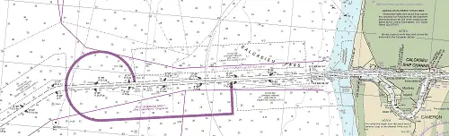
Algiers Navigation Canal Inlet
The Algiers Navigation Canal is located at MM "88.2 AHP" (97.8 NM above the Southwest Pass Entrance). It allows access to the GIWW when westbound. The canal has good water bank to bank and is crossed by (3) bridges, (1) fixed and (2) lift bridges. All bridges offer 100 feet of clearance.
The canal entrance is on the south side of the Mississippi River and intersects the GIWW at MM ("6.5 WHL" near lighted beacon (Fl (2+1) R 6s 20ft 3M).
Inner Harbor Navigation Canal
The Inner Harbor Navigation Canal entrance is on the north side of the Mississippi River and provides access to and is part of the Gulf Intracoastal Waterway. This inlet is for vessels eastbound on the GIWW.
The intersection with the GIWW takes place at MM "92.5" AHP located approximately 101.6 NM above the Southwest Pass Entrance or about 80.5 NM Above Head of Passes (AHP). The inlet is marked by (2) lighted beacons: Fl G 2.5s 30ft 4M "1" on the west side and Q R 40ft 4M "2" on the east side.
Cautions – When turning in from the Mississippi River, be aware of a stump awash (at 9.9 feet water level) about 10 feet out from the east bank.
Tides and Currents – Tides in this area are almost non-existent except at the lowest of Mississippi River Water Stages. Tidal currents likewise do not exist other than the currents due to the outflow of the river.
Harvey Canal
Located approximately 2.9 miles above the Crescent City Connector Bridges, it is marked by a traffic light to control entry. This canal is actually part of the Gulf Intracoastal Waterway with the Harvey Lock being MM "0.0." It marks the split between mileages measured East of Harvey Lock (EHL) and West of Harvey Lock (WHL).
The canal has good water bank to bank and is crossed by both bascule and fixed bridges with a minimum vertical clearance of 95 feet.