| New Jersey Intracoastal Waterway | |||||
|---|---|---|---|---|---|
| Manasquan to Atlantic City | |||||
| Mile Marker | Bridge | Charted Vert. Clear. | Schedule | Restrictions | VHF |
| 0.9 | Brielle RR Bascule Bridge | 3’ | Normally Open | Closes for RR traffic. | 13 |
| 1.1 | Route 35 Bascule Bridge | 30’ | Opens on Demand | 5/15 to 9/30 - On Saturdays, Sundays and Federal holidays, from 0800 to 2200, the draw need only open on the 1/4 and 3/4 hour. On Mon. thru Thu. from 1600 to 1900, and Fri. xcept Fed. holidays from 1200 to 1900, the draw need only open on the 1/4 and 3/4 hour. Year-round from 2300 to 0800, the draw need only open if at least four hours notice is given. | 13 |
| 2.8 | Route 88 Lift Bridge | 31’ | Opens on Demand | 66’ Open | 13 |
| 3.7 | Route 13 Lift Bridge | 30’ | Opens on Demand | 65’ Open | 13 |
| 6.3 | Mantoloking Bascule Bridge | 30’ | Opens on Demand | Memorial Day through Labor Day on weekends and Federal holidays from 0900 to 1800, the draw need only open on the hour, 20 minutes after the hour, and 40 minutes after the hour. | 13 |
| 14.1 | J. Stanley Tunney | 60’ | Fixed Bridge | ||
| 14.1 | Route 37 Bascule Bridge | 30’ | Opens on Demand | From 12/1 through 3/31, the draw need only open if at least four hours notice is given. From 4/1 through 11/30 from 2300 to0800, the draw need only open if at least four hours notice is given. From Memorial Day through Labor Day from 0800 to 2000, the draw need only open on the hour and half hour. | 13 |
| 36.1 | Donald J Henderson Bridge (Route 72) |
55’ | Fixed Bridge | Twin Spans | |
| 67.2 | Route 30 Bascule Bridge | 20’ | 4/1 to 10/31 - 0700-2300 need only open on the hour. 4 Hour notice at all other times. 11/1 to 3/31 4 Hour notice at all times. | On 7/4 or 7/5 the draw need not open from 2140 - 2315. During the Atlantic City Airshow the draw will open every 2 hours on the hour from 1000-1600 and need not open from 1600-2000. From 0800 on November 1, 2021, to 1700 on March 31, 2022; and from 0800 on November 1, 2022, to 1700 on March 31, 2023, the drawbridge will be in the closed-to-navigation position. Work will reduce the vertical clearance to approximately 19 feet above mean high water in the closed position. Vessels that can safely transit with the reduced clearances may do so, if at least 30 minutes notice is given. |
13 |
| 68.9 | AMTRAK RR Swing Bridge | 5’ | Opens on signal from 2300-0600. From 0600-2300, the draw shall open on signal from 20 to 30 minutes after each hour. | Opening of the draw may be delayed for RR traffic | 13 |
BlueSeas
New Jersey Intracoastal Waterway
New Jersey Intracoastal - (NJICW/NJIWW)
Cruising the NJICW - Manasquan to Cape May
The New Jersey Intracoastal Waterway (NJICW) stretches about 117.7 SM (102.3 NM) from Manasquan Inlet, located about 40 NM south of New York City, to the western entrance to the Cape May Canal on the Delaware Bay.
Beginning at Manasquan Inlet, the NJICW takes you up the Manasquan River before turning south and entering the Pt. Pleasant Canal which connects to the northern reaches of Barnegat Bay. Once through Barnegat Bay, it continues south taking you through a torturous winding route, reminiscent of the AICW in Georgia; passing through marshes and small bays until finally arriving in Cape May Harbor. From Cape May Harbor your route turns west into the Cape May Canal for about 3.7 SM before arriving at the Delaware Bay about 2 NM north of Cape May Point, NJ.
Aids to Navigation
Buoys and Marks
Navigation is fairly straight forward, New Jersey Intracoastal Waterway buoys and beacons are marked like most other lateral marks in the U.S. the difference is that either Yellow Triangles or Yellow Squares are added to the mark to indicate they are ICW markers.
The rule is: When proceeding south on the NJICW (Manasquan, NJ to Cape May, NJ), markers with yellow triangles are kept to starboard and yellow squares are kept to port at all times.


- “Yellow Squares are ALWAYS kept to port”
- and
- “Yellow Triangles are ALWAYS kept to starboard”
Regardless of the Color of the Mark!
This becomes critically important when the ICW temporarily merges with or crosses a second navigable channel.
Lights and daybeacons should not be passed close aboard because those marking dredged channels are usually placed back from the bottom edge of the channel and others may have rip-rap mounds around them to protect the structures.
Charts
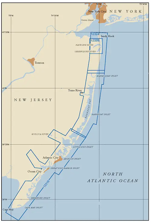
NOAA Charts #12324, #12316, and #12317 provide coverage of the New Jersey ICW from Sandy Hook, NJ south to Cape May. Chart #12317 provides a large scale harbor chart of Cape May.
Chart #12324 - NJICW - Sandy Hook to Little Egg Harbor provides coverage of the New Jersey Intracoastal Waterway from Mile Marker 0.0 in Manasquan, NJ to approximately Mile Marker 45.0 at Long Beach, NJ.
Chart #12316 - NJICW - Little Egg Harbor to Cape May provides coverage of the New Jersey Intracoastal Waterway from Mile Marker 45.0 in Long Beach, NJ to approximately Mile Marker 118.0 at Cape May, NJ.
Chart # 12317 - Cape May Harbor provides large scale coverage of Cape May Harbor.
Distances and Mileages
All distances along the New Jersey Intracoastal Waterway are given in statute miles unless otherwise noted. Statute miles are used in order to conform to the distances shown on the small craft charts typically used along this route.
The New Jersey ICW (southbound) is measured based on increasing mileage between Manasquan Inlet (MM "0.0") and the western end of the Cape May Canal (MM "117.7") which marks the official end the New Jersey Intracoastal Waterway.
Channel Depths
The proverbial fly in the ointment! Every effort is made to maintain a controlling depth of 6’ throughout the waterway, but due to continuous shoaling, depths of 3’ MLW may be found especially in the areas south of Barnegat Bay.
The Cape May Canal Project Depth is 12’ between Cape May Harbor and the Delaware Bay. Mariners should be aware that the last survey of the Cape May Canal, done in April 2013, showed a least controlling depth of 4.1 feet mid-channel with 1.2 feet in the left outside quarter, between Spicer Creek Canal and the Delaware Bay at MLLW.
Communications
Bridges – VHF Channel 13.
Bridges, Locks, and Overhead Power Lines
New Jersey Intracoastal Waterway - Bridge Schedule
From Manasquan Inlet to Absecon Inlet the minimum clearance found for fixed bridges is 60 feet. From Absecon Inlet south to the Delaware Bay, the minimum clearance is 35 feet.
The following table lists the bridges; their schedules, and restrictions along the New Jersey Intracoastal Waterway (NJICW).
This list is believed to be accurate as of July 2026. If any errors or omissions are noted, please e-mail us at with any corrections or recommendations.
| New Jersey Intracoastal Waterway | |||||
|---|---|---|---|---|---|
| Atlantic City to Cape May | |||||
| Mile Marker | Bridge | Charted Vert. Clear. | Schedule | Restrictions | VHF |
| 68.9 | A C Expressway Bridge | 35’ | Fixed Bridge | ||
| 70.0 | Albany Ave. Bascule Bridge | 10’ | Opens on demand except that: Year round 2300-0700 and from 11/1-3/31 1500-2300 4 hour notice is required. 6/1 to 9/30 - 0900-1600 and 1800-2100 opens on the hour and 1/2 hour. From 1600-1800 the bridge need not open. | On 7/4 or 7/5 the draw need not open from 2140-2315. For the Atlantic City Airshow (the 3rd or 4th Wednesday of August), the draw will open every 2 hours on the hour from 1000-1600 and need not open from 1600-2000. | 13 |
| 72.1 | Dorsett Ave. Bascule Bridge | 9’ | 6/1 thru 9/30 – From 0915 to 2115 opens on the 1/4 and 3/4 hour. Other times on demand. | 13 | |
| 72.9 | Margate Bascule Bridge | 14’ | Opens on Demand | 13 | |
| 77.5 | Route 152 Bridge | 56’ | Fixed Bridge | ||
| 80.4 | Route 52 Bridge | 55’ | Fixed Bridge | ||
| 84.0 | Roosevelt Avenue Bridge | 35’ | Fixed Bridge | ||
| 93.0 | County 625 Bridge | 35’ | Fixed Bridge | ||
| 97.2 | County 601 Bridge | 35’ | Fixed Bridge | ||
| 102.0 | Stone Harbor Blvd Bascule Bridge | 10’ | Memorial Day thru Labor Day from 0600 to 1800 on weekends and Fed. holidays, opens on the hour and every 20 minutes thereafter. From 10/1 through 3/31 from 2200 to 0600 opens with eight hours notice. Other times on demand. | From 2200 on 12/24 until 0600 on 12/26, the draw need open only if at least two hours notice is given. | 13 |
| 106.6 | N. Wildwood Blvd. Bridge | 55’ | Fixed Bridge | ||
| 108.9 | G Redding Bascule Bridge | 25’ | Opens on Demand | 13 | |
| 112.2 | Two Mile Bascule Bridge | 23’ | From 0915 to 1030 on the fourth Sunday in March of every year, the draw need not open for vessels. If the fourth Sunday falls on a religious holiday, the draw need not open for vessels from 0915 to 1030 on the third Sunday of March of every year. From 2230 on 12/24 until 2230 on 12/26, the draw need open only if at least two hours notice is given. Other times on demand | NOTE: A proposal to replace this bridge with a 80’ vert. clnc. fixed bridge has been submitted to the USCG for approval. | 13 |
| 115.2 | GSP Bridge | 55’ | Fixed Bridge | ||
| 116.1 | Seashore RR Swing Bridge | 4’ | Normally Open | Closes for RR Traffic | 13 |
| 116.2 | NJ 162 Bridge | 55’ | Fixed Bridge | ||
The above table can be downloaded for your personal and private use. The New Jersey Intracoastal Waterway Bridge List contains the tables in Statute Miles, Nautical Miles, and Kilometers. The files are Zipped Adobe (.pdf) format.
NJICW Bridge Schedule - Download
New Jersey Intracoastal Waterway - Locks
None.
New Jersey Intracoastal Waterway - Overhead Cables and Power Lines
At last count, there were (12) cable crossings on the NJICW. Manasquan Inlet south to Absecon Inlet (Atlantic City) the minimum authorized clearance found for overhead cables is 72 feet on the northern end of the Pt. Pleasant Canal. From Absecon Inlet south, the minimum clearance for overhead cables is 35 feet found at the Roosevelt Blvd. Bridge.
Tides and Currents
The tidal range varies by location, with areas near inlets having a higher range than in areas well away from the inlets. Manasquan Inlet has a mean tidal range of 4.0 feet, Barnegat Inlet at 2.2 feet, Atlantic City with 4.0 feet, and the Cape May Canal (western entrance) at 4.8 feet.
Caution should be observed during times of strong long duration winds as they may cause variations in tidal levels of as much as 3 feet below MLW and 3 feet above MHW.
Current velocities may reach 3 knots in the inlets and their connecting channels leading to the NJICW while in the back bays portion of the NJICW the currents are less.
Extra caution should be exercised when transiting the Pt. Pleasant Canal. A combination of strong tidal currents, heavy boat traffic, (2) lift bridges, direct and reflected waves, wakes, and chop all combined and packed into a steel bulk-headed canal about 1.8 miles long and averaging about 135’ wide will require a little more attention by the captain.
New Jersey’s Entrances, Inlets, and Passes
There are numerous Entrances, Inlets, or Passes between the deep waters of the Atlantic Ocean and the outer coastline of New Jersey. Between Sandy Hook in the north to Cape May in the south, there were 12 at last count. The principal shallow-draft entrances are Shrewsbury River inlet, Shark River Inlet, Manasquan Inlet, Barnegat Inlet, Absecon Inlet and Cape May Inlet. There are several others that are unimproved and/or require local knowledge to safely enter.
Most all provide access to sheltered inland waters as well as providing access to the New Jersey Intracoastal Waterway.
The best time to enter any New Jersey Inlet is on a rising tide with a smooth sea; passage can become extremely hazardous during easterly gales and heavy seas.
We have listed them on the next page along with useful information on each to aid you in deciding if you wish to use a particular inlet.
